
Skeda:2010 Chile earthquake epicenter.png
Nuk ka përmasa më të madhaja.
2010_Chile_earthquake_epicenter.png ((përmasa 269 × 589 px, madhësia skedës: 112 KB, lloji MIME: image/png))
| Kjo skedë është prej Wikimedia Commons dhe mund të përdoret nga projekte të tjera. Përshkrimi në këtë skedë në këtë faqe nuk është treguar më poshtë. | Shko tek faqja përshkruese në Commons |
| Përshkrimi |
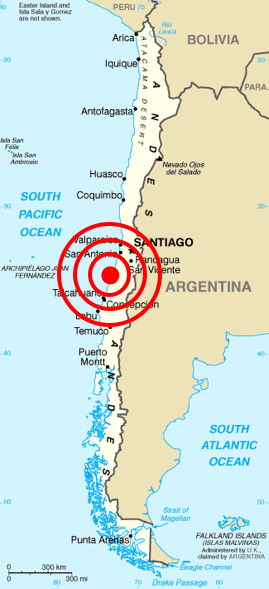
Deutsch: Karte von Chile aus dem CIA World Factbook mit dem Epizentrum des Erdbebens 2010 Chile
Español: Mapa de Chile de la CIA World Factbook, con el epicentro del terremoto de Chile 2010
Français : Carte du Chili de la CIA World Factbook avec l'épicentre du tremblement de terre du Chili 2010
Português: Mapa do Chile da CIA World Factbook, com o epicentro do terremoto do Chile em 2010 |
| Data | (original); 2010-02-27 (This image) |
| Burimi | Originally from Central Intelligence Agency's World Factbook. Location of epicenter from BBC |
| Autori | Central Intelligence Agency's World Factbook |
| Leja (Ripërdor këtë skedë) |
PD-USGOV-CIA-WF. |
Licencim
This image is in the public domain because it contains materials that originally came from the United States Central Intelligence Agency's World Factbook.
|
 |
| Annotations | This image is annotated: View the annotations at Commons |
Historiku skedës
Shtypni mbi një datë/kohë për ta parë skedën siç ishte atëherë.
| Data/Koha | Miniaturë | Përmasat | Përdoruesi | Koment | |
|---|---|---|---|---|---|
| e tanishme | 27 shkurt 2010 15:45 | | 269 × 589 (112 KB) | Cargoking | {{Information |Description=Map of en:Chile from [http://www.lib.utexas.edu/maps/cia02/chile_sm02.gif CIA World Factbook] with the epicenter of 2010 Chile earthquake marked. |Source=Originally from Central Intelligence Agen |
Lidhje skedash
Këto faqe lidhen tek kjo skedë:
Përdorimi global i skedës
Kjo skedë përdoret nga Wiki të tjera në vijim:
- Përdorimi në be.wikipedia.org
- Përdorimi në bg.wikipedia.org
- Përdorimi në ckb.wikipedia.org
- Përdorimi në cy.wikipedia.org
- Përdorimi në da.wikipedia.org
- Përdorimi në en.wikipedia.org
- Përdorimi në en.wikinews.org
- Përdorimi në eo.wikipedia.org
- Përdorimi në es.wikinews.org
- Përdorimi në et.wikipedia.org
- Përdorimi në fa.wikipedia.org
- Përdorimi në fi.wikipedia.org
- Përdorimi në fr.wikinews.org
- Përdorimi në ja.wikipedia.org
- Përdorimi në ka.wikipedia.org
- Përdorimi në lt.wikipedia.org
- Përdorimi në ml.wikipedia.org
- Përdorimi në ms.wikipedia.org
- Përdorimi në no.wikinews.org
- Përdorimi në pt.wikinews.org
- Përdorimi në ro.wikipedia.org
- Përdorimi në ro.wikinews.org
- Përdorimi në ru.wikipedia.org
- Përdorimi në ru.wikinews.org
- Përdorimi në sh.wikipedia.org
- Përdorimi në simple.wikipedia.org
- Përdorimi në sr.wikipedia.org
- Përdorimi në sv.wikipedia.org
- Përdorimi në ta.wikinews.org
- Përdorimi në th.wikipedia.org
- Përdorimi në tr.wikipedia.org
- Përdorimi në uk.wikinews.org
- Përdorimi në vi.wikipedia.org
- Përdorimi në www.wikidata.org
- Përdorimi në zh.wikipedia.org