
Skeda:Hispaniola lrg.jpg

Madhësia e këtij shikimi: 800 × 361 pixel. Rezolucione të tjera: 320 × 145 pixel | 640 × 289 pixel | 1.024 × 463 pixel | 1.280 × 578 pixel | 3.000 × 1.355 pixel.
Dokument origjinal ((përmasa 3.000 × 1.355 px, madhësia skedës: 778 KB, lloji MIME: image/jpeg))
| Kjo skedë është prej Wikimedia Commons dhe mund të përdoret nga projekte të tjera. Përshkrimi në këtë skedë në këtë faqe nuk është treguar më poshtë. | Shko tek faqja përshkruese në Commons |
| Përshkrimi |
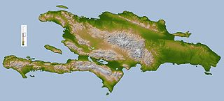
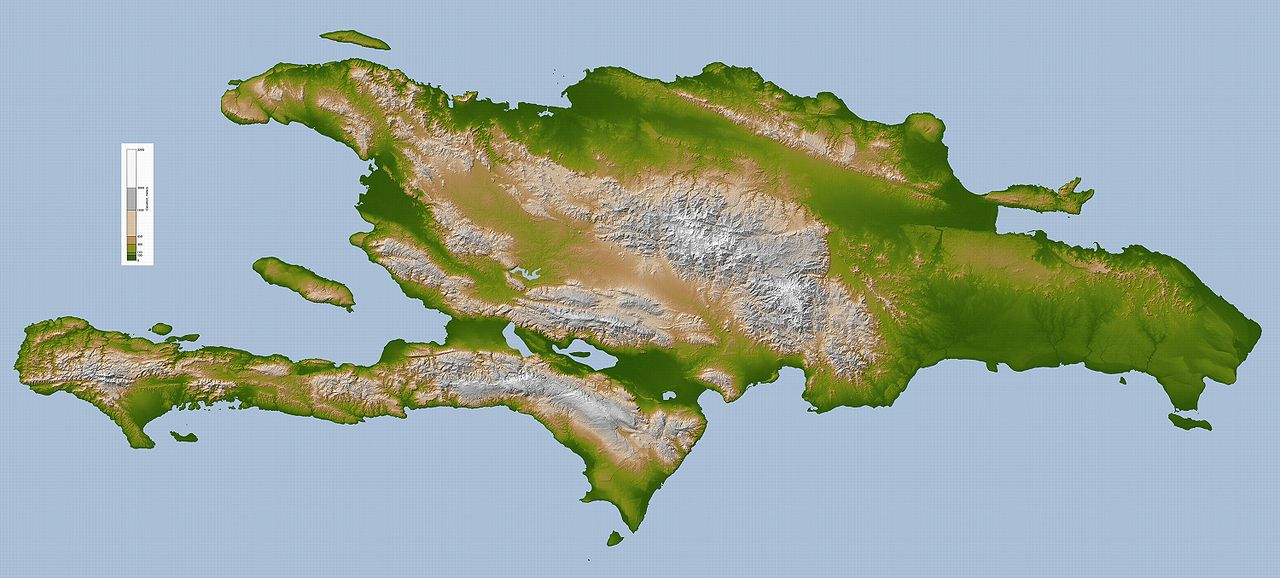
English: Topography map of Hispaniola.
Deutsch: Hispaniola. |
|||||
| Burimi |
Image Courtesy: NASA/JPL/SRTM
|
|||||
| Autori | NASA/JPL/SRTM | |||||
| Leja (Ripërdor këtë skedë) |
|
|||||
| Versione tjera | Derivative works of this file: Hispaniola lrg Bg.jpg |


|
Kjo map fotografi duhet duhen te behen edhe i here si nje SVG.
|


Historiku skedës
Shtypni mbi një datë/kohë për ta parë skedën siç ishte atëherë.
| Data/Koha | Miniaturë | Përmasat | Përdoruesi | Koment | |
|---|---|---|---|---|---|
| e tanishme | 6 tetor 2005 13:00 | | 3.000 × 1.355 (778 KB) | ChongDae | This image was copied from wikipedia:en. The original description was: Topography map of Hispaniola image description [http://earthobservatory.nasa.gov/Newsroom/NewImages/images.php3?img_id=16574 here] larger version [http://earthobservatory.nasa.gov/N |
Lidhje skedash
Këto faqe lidhen tek kjo skedë:
Përdorimi global i skedës
Kjo skedë përdoret nga Wiki të tjera në vijim:
- Përdorimi në af.wikipedia.org
- Përdorimi në als.wikipedia.org
- Përdorimi në ang.wikipedia.org
- Përdorimi në an.wikipedia.org
- Përdorimi në ar.wikipedia.org
- Përdorimi në ar.wikinews.org
- Përdorimi në ast.wikipedia.org
- Përdorimi në az.wiktionary.org
- Përdorimi në be.wikipedia.org
- Përdorimi në bjn.wikipedia.org
- Përdorimi në bn.wikipedia.org
- Përdorimi në br.wikipedia.org
- Përdorimi në bs.wikipedia.org
- Përdorimi në ca.wikipedia.org
- Përdorimi në cs.wikipedia.org
- Përdorimi në da.wikipedia.org
- Përdorimi në de.wikipedia.org
- Përdorimi në de.wiktionary.org
- Përdorimi në el.wikipedia.org
- Përdorimi në en.wikipedia.org
- Përdorimi në eo.wikipedia.org
- Përdorimi në es.wikipedia.org
- Përdorimi në et.wikipedia.org
- Përdorimi në fa.wikipedia.org
- Përdorimi në fi.wikipedia.org
- Përdorimi në fo.wikipedia.org
- Përdorimi në frr.wikipedia.org
- Përdorimi në fr.wikipedia.org
- Përdorimi në fr.wiktionary.org
- Përdorimi në ga.wikipedia.org
- Përdorimi në gd.wikipedia.org
Shikoni më shumë përdorim global të kësaj skede.