
Skeda:Klimagürtel-der-erde-tundra.png
Madhësia e këtij shikimi: 800 × 400 pixel. Rezolucione të tjera: 320 × 160 pixel | 640 × 320 pixel | 1.024 × 512 pixel | 1.280 × 640 pixel | 3.600 × 1.800 pixel.
Dokument origjinal ((përmasa 3.600 × 1.800 px, madhësia skedës: 678 KB, lloji MIME: image/png))
| Kjo skedë është prej Wikimedia Commons dhe mund të përdoret nga projekte të tjera. Përshkrimi në këtë skedë në këtë faqe nuk është treguar më poshtë. | Shko tek faqja përshkruese në Commons |
Përmbledhje
| Përshkrimi |
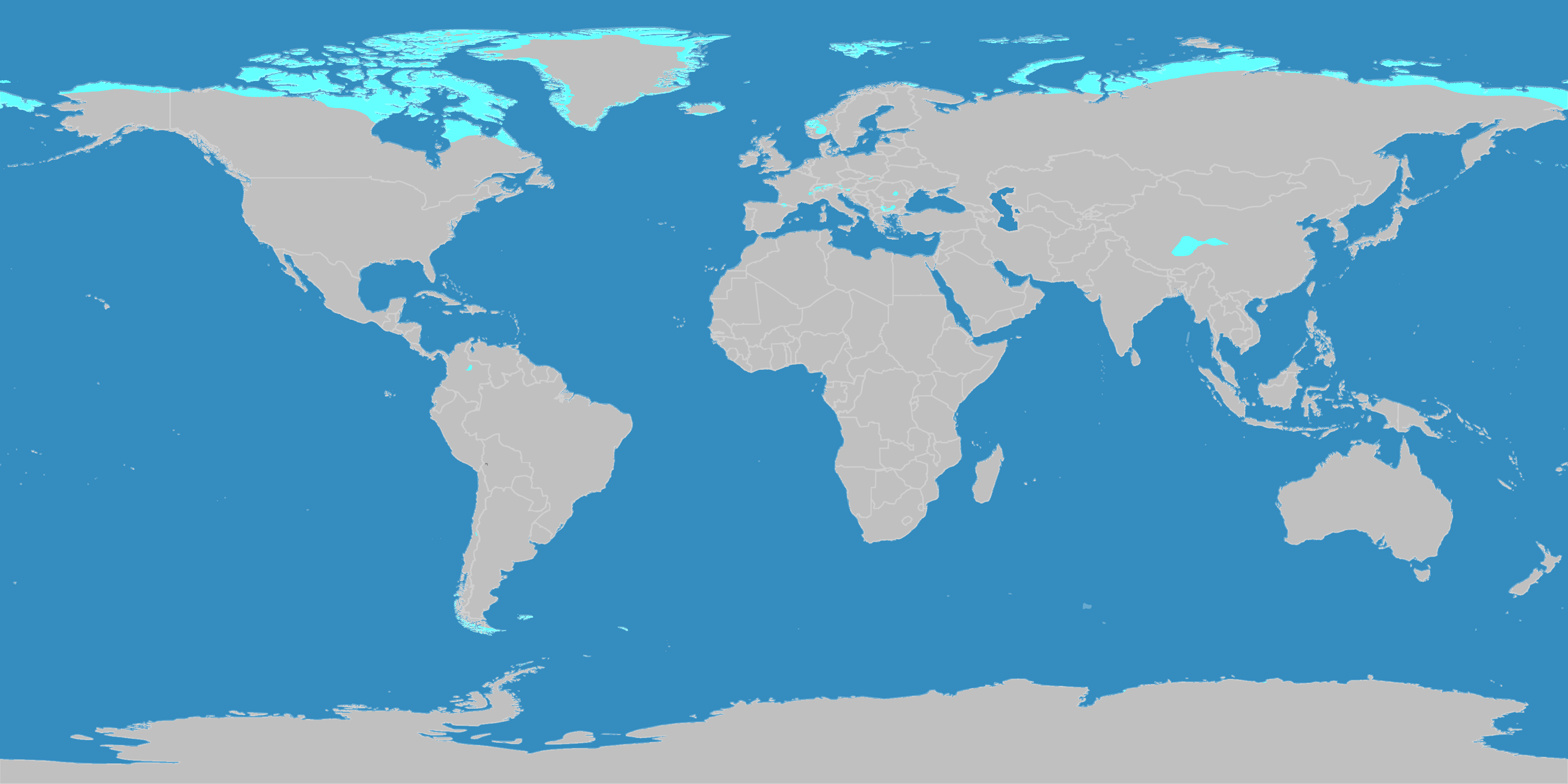
English: This map shows the Earth zones with a polar tundra climate. Deutsch: Diese Karte stellt die Tundrenzone der Erde dar. |
| Data | |
| Burimi |
English: Own work on the basis of the following data: Deutsch: Selbst erstellt auf Basis dieser Geodaten:
|
| Autori | LordToran |
| Leja (Ripërdor këtë skedë) |
|
| Versione tjera |
 |
Licencim
Kjo skedë licencohet sipas Creative Commons Attribution-Share Alike 3.0 Unported.
- Je i lirë të:
- ta shpërndani – ta kopjoni, rishpërndani dhe përcillni punën
- t’i bëni “remix” – të përshtatni punën
- Sipas kushteve të mëposhtme:
- atribuim – Duhet t’i jepni meritat e duhura, të siguroni një lidhje për tek licenca dhe të tregoni nëse janë bërë ndryshime. Këtë mund ta bëni në ndonjë mënyrë të arsyeshme, por jo në ndonjë mënyrë që sugjeron se licencuesi ju del zot juve apo përdorimit tuaj.
- share alike – Nëse bëni një “remix”, e shndërroni, ose ndërtoni duke u bazuar te materiali, duhet t’i shpërndani kontributet tuaja sipas të njëjtës licencë ose një të tille të përputhshme me origjinalen.
Historiku skedës
Shtypni mbi një datë/kohë për ta parë skedën siç ishte atëherë.
| Data/Koha | Miniaturë | Përmasat | Përdoruesi | Koment | |
|---|---|---|---|---|---|
| e tanishme | 11 tetor 2016 23:09 | | 3.600 × 1.800 (678 KB) | Maphobbyist | The Caspian Sea was omitted. The Köppen system is based on the concept that climate types are correlated with the natural vegetation. |
| 15 tetor 2007 17:28 |  | 3.600 × 1.800 (573 KB) | Lortordermur | ||
| 5 qershor 2007 22:50 |  | 3.445 × 1.731 (621 KB) | Lortordermur | == Beschreibung == {{Information |Description=Diese Karte stellt die Tundrenzone der Erde dar. |Source=Selbst erstellt auf Basis [http://www.copernicus.org/EGU/hess/hessd/4/439/hessd-4-439.htm dieser Karte], welche unter einer Creative-Commons-Lizenz ste |
Lidhje skedash
Këto faqe lidhen tek kjo skedë:
Përdorimi global i skedës
Kjo skedë përdoret nga Wiki të tjera në vijim:
- Përdorimi në ca.wikipedia.org
- Përdorimi në de.wikipedia.org
- Përdorimi në es.wikibooks.org
- Përdorimi në eu.wikipedia.org
- Përdorimi në lij.wikipedia.org
- Përdorimi në nl.wikipedia.org