
Skeda:Mali map.png
Nuk ka përmasa më të madhaja.
Mali_map.png ((përmasa 350 × 376 px, madhësia skedës: 11 KB, lloji MIME: image/png))
| Kjo skedë është prej Wikimedia Commons dhe mund të përdoret nga projekte të tjera. Përshkrimi në këtë skedë në këtë faqe nuk është treguar më poshtë. | Shko tek faqja përshkruese në Commons |

|
Kjo locator map fotografi duhet duhen te behen edhe i here si nje SVG.
|
Përmbledhje
| Përshkrimi |
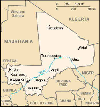
English: Map of Mali |
| Data | |
| Burimi | https://www.cia.gov/library/publications/the-world-factbook/geos/ml.html |
| Autori | CIA |
Licencim
| This image is a work of a Central Intelligence Agency employee, taken or made as part of that person's official duties. As a Work of the United States Government, this image or media is in the public domain in the United States.
|

|
Historiku skedës
Shtypni mbi një datë/kohë për ta parë skedën siç ishte atëherë.
| Data/Koha | Miniaturë | Përmasat | Përdoruesi | Koment | |
|---|---|---|---|---|---|
| e tanishme | 3 mars 2005 23:03 | | 350 × 376 (11 KB) | Alfio | CIA map of Mali |
Lidhje skedash
Këto faqe lidhen tek kjo skedë:
Përdorimi global i skedës
Kjo skedë përdoret nga Wiki të tjera në vijim:
- Përdorimi në als.wikipedia.org
- Përdorimi në am.wikipedia.org
- Përdorimi në ast.wikipedia.org
- Përdorimi në bjn.wikipedia.org
- Përdorimi në ca.wikipedia.org
- Përdorimi në ceb.wikipedia.org
- Përdorimi në da.wikipedia.org
- Përdorimi në de.wikivoyage.org
- Përdorimi në en.wikipedia.org
- Përdorimi në es.wikipedia.org
- Përdorimi në eu.wikipedia.org
- Përdorimi në fa.wikipedia.org
- Përdorimi në fi.wikipedia.org
- Përdorimi në fo.wikipedia.org
- Përdorimi në fr.wikipedia.org
- Përdorimi në he.wikipedia.org
- Përdorimi në hi.wiktionary.org
- Përdorimi në hu.wikipedia.org
- Përdorimi në hu.wiktionary.org
- Përdorimi në id.wikipedia.org
- Përdorimi në io.wikipedia.org
- Përdorimi në ja.wikipedia.org
- Përdorimi në jv.wikipedia.org
- Përdorimi në ko.wikipedia.org
- Përdorimi në mr.wikipedia.org
- Përdorimi në nds.wikipedia.org
- Përdorimi në nl.wikipedia.org
- Përdorimi në no.wikipedia.org
- Përdorimi në oc.wikipedia.org
- Përdorimi në pl.wikipedia.org
- Përdorimi në pt.wikipedia.org
- Përdorimi në ro.wikipedia.org
Shikoni më shumë përdorim global të kësaj skede.