
Skeda:Map of Illinois highlighting LaSalle County.svg

Size of this PNG preview of this SVG file: 336 × 599 pixel. Rezolucione të tjera: 134 × 240 pixel | 269 × 480 pixel | 430 × 768 pixel | 574 × 1.024 pixel | 1.148 × 2.048 pixel | 3.453 × 6.157 pixel.
Dokument origjinal (skedë SVG, fillimisht 3.453 × 6.157 pixel, madhësia e skedës: 85 KB)
| Kjo skedë është prej Wikimedia Commons dhe mund të përdoret nga projekte të tjera. Përshkrimi në këtë skedë në këtë faqe nuk është treguar më poshtë. | Shko tek faqja përshkruese në Commons |
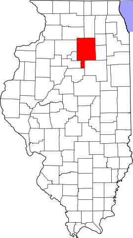
This is a locator map showing LaSalle County in Illinois.
David Benbennick made this map. For more information, see Commons:United States county locator maps.
| Unë,krijuesi i kësaj pune, e lëshoj këtë punë në public domain. Kjo aplikohet në të gjithë botën. Në disa vende kjo mund të mos jetë e mundur ligjërisht; nëse është kështu: Unë i garantoj çdokujt të drejtën për ta përdorur këtë punë për çdo qëllim, pa asnjë kusht, përveç rasteve kur këto kushte janë të kërkuara nga ligji. |
Historiku skedës
Shtypni mbi një datë/kohë për ta parë skedën siç ishte atëherë.
| Data/Koha | Miniaturë | Përmasat | Përdoruesi | Koment | |
|---|---|---|---|---|---|
| e tanishme | 5 prill 2007 15:26 | | 3.453 × 6.157 (85 KB) | Ruhrfisch | This is a locator map showing La Salle County in Illinois. David Benbennick made this map. For more information, see Commons:United States county locator maps. {{PD-self}} [[Category:La Salle Count |
Lidhje skedash
S’ka faqe që përdorin këtë kartelë.
Përdorimi global i skedës
Kjo skedë përdoret nga Wiki të tjera në vijim:
- Përdorimi në ar.wikipedia.org
- مقاطعة لاسال (إلينوي)
- نورث يوتيكا (إلينوي)
- دالزل (إلينوي)
- كانغلي (إلينوي)
- ليونوري (إلينوي)
- نابلت (إلينوي)
- سينيسا (إلينوي)
- تروي غروف (إلينوي)
- سيدار بوينت (إلينوي)
- دانا (إلينوي)
- غراند ريدج (إلينوي)
- ليلاند (إلينوي)
- لوستانت (إلينوي)
- أوتاوا (إلينوي)
- سترتور
- بيرو (إلينوي)
- لاسال
- مرسيليا (إلينوي)
- إيرلفيل
- ميندوتا
- أوغلسبي
- وينونا
- ميلينغتون (إلينوي)
- رانسوم (إلينوي)
- روتلاند (إلينوي)
- شريدان (إلينوي)
- سوموناك (إلينوي)
- تونيكا (إلينوي)
- قالب:مقاطعة لاسال (إلينوي)
- Përdorimi në bg.wikipedia.org
- Përdorimi në ca.wikipedia.org
- Llista de comtats d'Illinois
- Cedar Point (Illinois)
- Dalzell (Illinois)
- Dana (Illinois)
- Earlville (Illinois)
- Grand Ridge (Illinois)
- Kangley
- La Salle (Illinois)
- Leland (Illinois)
- Leonore (Illinois)
- Lostant
- Marseilles (Illinois)
- Mendota (Illinois)
- Millington (Illinois)
- Naplate
- North Utica
- Oglesby (Illinois)
- Ottawa (Illinois)
Shikoni më shumë përdorim global të kësaj skede.