
Skeda:Map of New Jersey highlighting Somerset County.svg

Size of this PNG preview of this SVG file: 316 × 598 pixel. Rezolucione të tjera: 127 × 240 pixel | 253 × 480 pixel | 405 × 768 pixel | 541 × 1.024 pixel | 1.081 × 2.048 pixel | 1.426 × 2.700 pixel.
Dokument origjinal (skedë SVG, fillimisht 1.426 × 2.700 pixel, madhësia e skedës: 61 KB)
| Kjo skedë është prej Wikimedia Commons dhe mund të përdoret nga projekte të tjera. Përshkrimi në këtë skedë në këtë faqe nuk është treguar më poshtë. | Shko tek faqja përshkruese në Commons |
Përmbledhje
| Përshkrimi |
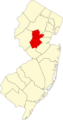
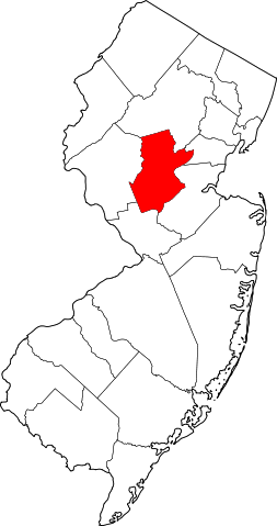
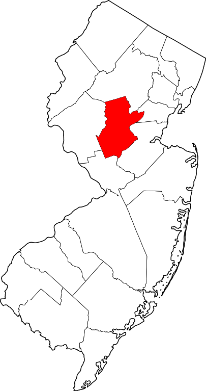
English: This is a locator map showing Somerset County in New Jersey. For more information, see Commons:United States county locator maps. |
| Data | |
| Burimi |
Punë e juaja: English: The maps use data from nationalatlas.gov, specifically countyp020.tar.gz on the Raw Data Download page. The maps also use state outline data from statesp020.tar.gz. The Florida maps use hydrogm020.tar.gz to display Lake Okeechobee. |
| Autori | David Benbennick |
Licencim
| Unë,krijuesi i kësaj pune, e lëshoj këtë punë në public domain. Kjo aplikohet në të gjithë botën. Në disa vende kjo mund të mos jetë e mundur ligjërisht; nëse është kështu: Unë i garantoj çdokujt të drejtën për ta përdorur këtë punë për çdo qëllim, pa asnjë kusht, përveç rasteve kur këto kushte janë të kërkuara nga ligji. |
Historiku skedës
Shtypni mbi një datë/kohë për ta parë skedën siç ishte atëherë.
| Data/Koha | Miniaturë | Përmasat | Përdoruesi | Koment | |
|---|---|---|---|---|---|
| e tanishme | 12 shkurt 2006 17:29 | | 1.426 × 2.700 (61 KB) | David Benbennick | {{subst:User:Dbenbenn/clm|county=Somerset County|state=New Jersey|type=county}} |
Lidhje skedash
S’ka faqe që përdorin këtë kartelë.
Përdorimi global i skedës
Kjo skedë përdoret nga Wiki të tjera në vijim:
- Përdorimi në ar.wikipedia.org
- Përdorimi në az.wikipedia.org
- Përdorimi në ban.wikipedia.org
- Përdorimi në bg.wikipedia.org
- Përdorimi në bpy.wikipedia.org
- Përdorimi në cdo.wikipedia.org
- Përdorimi në ceb.wikipedia.org
- Përdorimi në ce.wikipedia.org
- Përdorimi në cy.wikipedia.org
- Përdorimi në de.wikipedia.org
- Somerset County (New Jersey)
- Bernardsville
- Bound Brook
- Far Hills
- Manville (New Jersey)
- Millstone (New Jersey)
- North Plainfield
- Peapack-Gladstone
- Raritan (New Jersey)
- Rocky Hill (New Jersey)
- Somerset (New Jersey)
- Somerville (New Jersey)
- South Bound Brook
- Watchung
- Kingston (New Jersey)
- Basking Ridge (New Jersey)
- Vorlage:Navigationsleiste Orte im Somerset County (New Jersey)
- Përdorimi në en.wikipedia.org
Shikoni më shumë përdorim global të kësaj skede.