
Skeda:1991 Racha intensity.jpg
Madhësia e këtij shikimi: 512 × 599 pixel. Rezolucione të tjera: 205 × 240 pixel | 612 × 716 pixel.
Dokument origjinal ((përmasa 612 × 716 px, madhësia skedës: 197 KB, lloji MIME: image/jpeg))
| Kjo skedë është prej Wikimedia Commons dhe mund të përdoret nga projekte të tjera. Përshkrimi në këtë skedë në këtë faqe nuk është treguar më poshtë. | Shko tek faqja përshkruese në Commons |
Përmbledhje
| Përshkrimi |
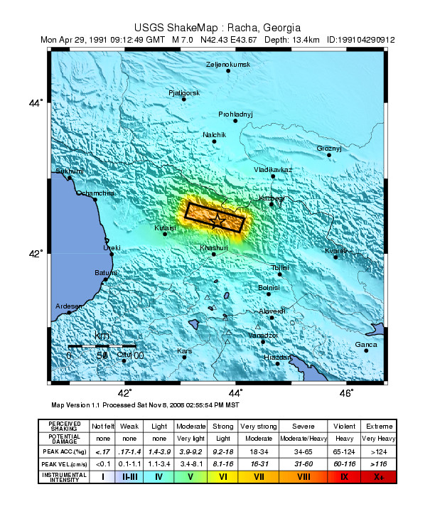
English: Seismic intensity map for the 1991 Racha earthquake, Georgia |
| Data | |
| Burimi | Shakemap Atlas [1] |
| Autori | USGS |
Licencim
This image is in the public domain in the United States because it only contains materials that originally came from the United States Geological Survey, an agency of the United States Department of the Interior. For more information, see the official USGS copyright policy.
|
Historiku skedës
Shtypni mbi një datë/kohë për ta parë skedën siç ishte atëherë.
| Data/Koha | Miniaturë | Përmasat | Përdoruesi | Koment | |
|---|---|---|---|---|---|
| e tanishme | 11 gusht 2010 00:12 | | 612 × 716 (197 KB) | Mikenorton | {{Information |Description={{en|1=Seismic intensity map for the 1991 Racha earthquake, Georgia}} |Source=Shakemap Atlas [http://earthquake.usgs.gov/earthquakes/shakemap/atlas/shake/199104290912/] |Author=USGS |Date=28 October 2009 |Permission= |other_vers |
Lidhje skedash
Këto faqe lidhen tek kjo skedë:
Përdorimi global i skedës
Kjo skedë përdoret nga Wiki të tjera në vijim:
- Përdorimi në ba.wikipedia.org
- Përdorimi në en.wikipedia.org
- Përdorimi në pl.wikipedia.org
- Përdorimi në ru.wikipedia.org
- Përdorimi në sv.wikipedia.org
- Përdorimi në tr.wikipedia.org
- Përdorimi në uz.wikipedia.org
- Përdorimi në www.wikidata.org