
Skeda:1730 Seutter Map of Turkey (Ottoman Empire), Persia and Arabia - Geographicus - MagniTurcarum-seutter-1740.jpg

Madhësia e këtij shikimi: 691 × 600 pixel. Rezolucione të tjera: 277 × 240 pixel | 553 × 480 pixel | 885 × 768 pixel | 1.180 × 1.024 pixel | 2.360 × 2.048 pixel | 5.000 × 4.339 pixel.
Dokument origjinal ((përmasa 5.000 × 4.339 px, madhësia skedës: 5,27 MB, lloji MIME: image/jpeg))
| Kjo skedë është prej Wikimedia Commons dhe mund të përdoret nga projekte të tjera. Përshkrimi në këtë skedë në këtë faqe nuk është treguar më poshtë. | Shko tek faqja përshkruese në Commons |
| Artist |
|
|||||||||||||||||||||||
| Title |
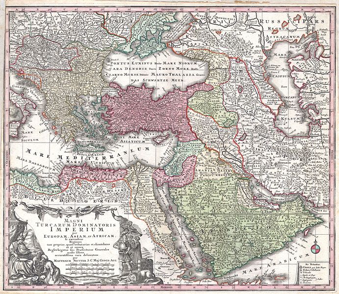
MAGNI TURCARUM DOMINATORIS IMPERIUM per EUROPAM, ASIAM ET AFRICAM, se extendens Regiones tam proprias, quan tributarias et clientelares ut et omnes Beglerbegatus sive Praefecturas Generales oculis sistens accuratissima cura delineatum per MATTHAEUM SEUTTER, S.C. Maj. Geogr. Aug. |
|||||||||||||||||||||||
| Përshkrimi |
English: A spectacular c. 1730 map of the Ottoman Empire, including Greece, Turkey, Persia, Egypt and Arabia, by the important Augsburg map publisher Gerog Matthaus Seutter. Depicts from Italy eastward to the Caspian Sea, which is depicted in its entirety. Includes Crimea and the Caucuses: Georgia, Circassia and Armenia. Extends south to include all of Arabia and the northern tip of the Horn of Africa. Generally accurate with a few cartographic anomalies. The Dead Sea is over-large and misshapen. A large and nonexistent lake appears just west of the Nile Delta. In the lower left hand quadrant there is a large decorative title cartouche attributed to the Augsburg silversmith Abraham Drentwet. Depicts the ottoman Emperor gloriously robed with and enthroned. On the ground before him two men bow and offer hum treasures. The images on the right of the title offer a more allegorical references and include an European holding a globe, a lion, the Rod of Asclepius, a Medusa head shield and s spear. Angels with trumpets look on from above. A map key appears in the lower right quadrant. Cartographically similar to Visscher's 1690 map of the same area. This is a rather unusual state of the map and one of the few examples wherein S.G. Maj Geogr. Aug follows Seutter's name in the title cartouche. The only comparable example we have found is in the British Museum. |
|||||||||||||||||||||||
| Data | circa 1730(undated) | |||||||||||||||||||||||
| Dimensions | lartësi: 20 in (50,8 cm); gjerësi: 23 in (58,4 cm) | |||||||||||||||||||||||
| Accession number |
Geographicus link: MagniTurcarum-seutter-1740 |
|||||||||||||||||||||||
| Source/Photographer |
Atlas Novus. Matthaeso Seutter. (1730)
|
|||||||||||||||||||||||
| Leja (Ripërdor këtë skedë) |
|
|||||||||||||||||||||||

,_Persia_and_Arabia_-_Geographicus_-_MagniTurcarum-seutter-1740.jpg)
Historiku skedës
Shtypni mbi një datë/kohë për ta parë skedën siç ishte atëherë.
| Data/Koha | Miniaturë | Përmasat | Përdoruesi | Koment | |
|---|---|---|---|---|---|
| e tanishme | 16 mars 2011 18:08 | | 5.000 × 4.339 (5,27 MB) | BotMultichill | {{subst:User:Multichill/Geographicus |link=http://www.geographicus.com/P/AntiqueMap/MagniTurcarum-seutter-1740 |product_name=1730 Seutter Map of Turkey (Ottoman Empire), Persia and Arabia |map_title=MAGNI TURCARUM DOMINATORIS IMPERIUM per EUROPAM, ASIAM E |
Lidhje skedash
Këto faqe lidhen tek kjo skedë:
Përdorimi global i skedës
Kjo skedë përdoret nga Wiki të tjera në vijim:
- Përdorimi në ar.wikipedia.org
- Përdorimi në arz.wikipedia.org
- Përdorimi në azb.wikipedia.org
- Përdorimi në az.wikipedia.org
- Përdorimi në bn.wikipedia.org
- Përdorimi në ckb.wikipedia.org
- Përdorimi në en.wikipedia.org
- Përdorimi në fa.wikipedia.org
- Përdorimi në fr.wikipedia.org
- Përdorimi në it.wikipedia.org
- Përdorimi në ko.wikipedia.org
- Përdorimi në ms.wikipedia.org
- Përdorimi në pnb.wikipedia.org
- Përdorimi në ru.wikipedia.org
- Përdorimi në sl.wikipedia.org
- Përdorimi në tr.wikipedia.org
- Përdorimi në uk.wikipedia.org
- Përdorimi në ur.wikipedia.org
- Përdorimi në zh.wikipedia.org
,_Persia_and_Arabia_-_Geographicus_-_MagniTurcarum-seutter-1740.jpg)