
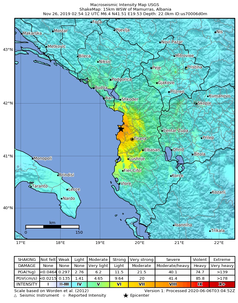
Skeda:2019-11-26 Mamurras, Albania M6.4 earthquake shakemap (USGS).jpg
Madhësia e këtij shikimi: 471 × 600 pixel. Rezolucione të tjera: 188 × 240 pixel | 377 × 480 pixel | 786 × 1.001 pixel.
Dokument origjinal ((përmasa 786 × 1.001 px, madhësia skedës: 388 KB, lloji MIME: image/jpeg))
| Kjo skedë është prej Wikimedia Commons dhe mund të përdoret nga projekte të tjera. Përshkrimi në këtë skedë në këtë faqe nuk është treguar më poshtë. | Shko tek faqja përshkruese në Commons |
.jpg)
Përmbledhje
| Përshkrimi | |
| Data | |
| Burimi | https://earthquake.usgs.gov/earthquakes/eventpage/us70006d0m |
| Autori | United States Geological Survey |
Licencim
This image is in the public domain in the United States because it only contains materials that originally came from the United States Geological Survey, an agency of the United States Department of the Interior. For more information, see the official USGS copyright policy.
|
Historiku skedës
Shtypni mbi një datë/kohë për ta parë skedën siç ishte atëherë.
| Data/Koha | Miniaturë | Përmasat | Përdoruesi | Koment | |
|---|---|---|---|---|---|
| e tanishme | 2 shtator 2020 13:34 | | 786 × 1.001 (388 KB) | IllCom | New Version by USGS |
| 19 dhjetor 2019 02:04 |  | 799 × 1.027 (384 KB) | Cewbot | Import USGS updated earthquake map, shakemap id: urn:usgs-product:us:shakemap:us70006d0m:1576710484988 (2019-12-18T23:08:04.988Z) | |
| 28 nëntor 2019 08:03 |  | 799 × 1.027 (384 KB) | Cewbot | Import USGS updated earthquake map, shakemap id: urn:usgs-product:us:shakemap:us70006d0m:1574918746692 (2019-11-28T05:25:46.692Z) | |
| 27 nëntor 2019 06:03 |  | 799 × 1.027 (384 KB) | Cewbot | Import USGS updated earthquake map, shakemap id: urn:usgs-product:us:shakemap:us70006d0m:1574823443193 (2019-11-27T02:57:23.193Z) | |
| 26 nëntor 2019 08:03 |  | 799 × 1.027 (384 KB) | Cewbot | Import USGS updated earthquake map, shakemap id: urn:usgs-product:us:shakemap:us70006d0m:1574744239038 (2019-11-26T04:57:19.038Z) | |
| 26 nëntor 2019 06:05 |  | 799 × 1.027 (384 KB) | Cewbot | Import USGS earthquake map, shakemap id: urn:usgs-product:us:shakemap:us70006d0m:1574739829558 (2019-11-26T03:43:49.558Z) |
Lidhje skedash
Këto faqe lidhen tek kjo skedë:
Përdorimi global i skedës
Kjo skedë përdoret nga Wiki të tjera në vijim:
- Përdorimi në az.wikipedia.org
- Përdorimi në bg.wikipedia.org
- Përdorimi në de.wikipedia.org
- Përdorimi në el.wikipedia.org
- Përdorimi në en.wikipedia.org
- Përdorimi në es.wikipedia.org
- Përdorimi në fr.wikipedia.org
- Përdorimi në he.wikipedia.org
- Përdorimi në hr.wikipedia.org
- Përdorimi në hu.wikipedia.org
- Përdorimi në id.wikipedia.org
- Përdorimi në it.wikipedia.org
- Përdorimi në ja.wikipedia.org
- Përdorimi në mr.wikipedia.org
- Përdorimi në pl.wikipedia.org
- Përdorimi në pt.wikipedia.org
- Përdorimi në ro.wikipedia.org
- Përdorimi në ru.wikipedia.org
- Përdorimi në te.wikipedia.org
- Përdorimi në tr.wikipedia.org
- Përdorimi në www.wikidata.org
- Përdorimi në zh.wikipedia.org
.jpg)