
Skeda:Albanian Kingdom (1939).svg

Size of this PNG preview of this SVG file: 450 × 456 pixel. Rezolucione të tjera: 237 × 240 pixel | 474 × 480 pixel | 758 × 768 pixel | 1.011 × 1.024 pixel | 2.021 × 2.048 pixel.
Dokument origjinal (skedë SVG, fillimisht 450 × 456 pixel, madhësia e skedës: 452 KB)
| Kjo skedë është prej Wikimedia Commons dhe mund të përdoret nga projekte të tjera. Përshkrimi në këtë skedë në këtë faqe nuk është treguar më poshtë. | Shko tek faqja përshkruese në Commons |


.svg)
.svg)
.svg)
.svg)
.svg)


.svg)
.svg)
.svg)


.png)
.png)


.svg)


.svg)

.svg)


.svg)
.svg)
.svg)
.svg)


.svg)
.png)


.svg)


.svg)
.svg)


.svg)


.svg)


.svg)
.svg)
.svg)
.svg)
.svg)
.svg)
.svg)
.svg)
_cropped.svg)
.svg)
.svg)
.svg)
.svg)
.svg)
.svg)
.svg)
.svg)
.svg)
.svg)
.svg)
.svg)
.svg)
.svg)
.svg)
.svg)
.svg)
.svg)
.svg)
.svg)
.svg)
.svg)
.svg)
.svg)
.svg)
.svg)
.svg)
.svg)
.svg)
.svg)
.svg)
.svg)
.svg)
.svg)
.svg)
.svg)
.svg)
.svg)
.svg)
.svg)
.svg)
.svg)
.svg)
.svg)
Historiku skedës
Shtypni mbi një datë/kohë për ta parë skedën siç ishte atëherë.
| Data/Koha | Miniaturë | Përmasat | Përdoruesi | Koment | |
|---|---|---|---|---|---|
| e tanishme | 25 korrik 2013 19:23 | | 450 × 456 (452 KB) | Alphathon | Removed the Flevoland polders (Netherlands) which were not completed until 1942/1968 |
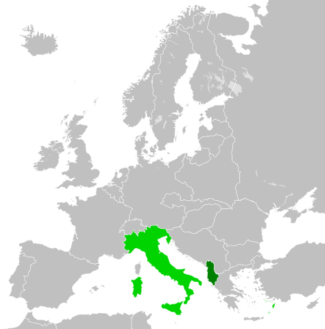
| 27 qershor 2012 05:33 |  | 450 × 456 (453 KB) | TRAJAN 117 | {{Information |Description ={{en|1=The Albanian Kingdom, with the Kingdom of Italy in 1939.}} |Source ={{own}} {{AttribSVG|Blank map of Europe October 1938 - March 1939.svg|Alphathon}} |Author =TRAJAN 117 {{create... |
Lidhje skedash
S’ka faqe që përdorin këtë kartelë.
Përdorimi global i skedës
Kjo skedë përdoret nga Wiki të tjera në vijim:
- Përdorimi në azb.wikipedia.org
- Përdorimi në da.wikipedia.org
- Përdorimi në el.wikipedia.org
- Përdorimi në en.wikipedia.org
- Përdorimi në fi.wikipedia.org
- Përdorimi në fr.wikipedia.org
- Përdorimi në it.wikipedia.org
- Përdorimi në ko.wikipedia.org
- Përdorimi në ms.wikipedia.org
- Përdorimi në pt.wikipedia.org
- Përdorimi në ru.wikipedia.org
- Përdorimi në sr.wikipedia.org
- Përdorimi në zh.wikipedia.org
.svg)