
Skeda:Balkan peninsula line.jpg
Nuk ka përmasa më të madhaja.
Balkan_peninsula_line.jpg ((përmasa 558 × 530 px, madhësia skedës: 169 KB, lloji MIME: image/jpeg))
| Kjo skedë është prej Wikimedia Commons dhe mund të përdoret nga projekte të tjera. Përshkrimi në këtë skedë në këtë faqe nuk është treguar më poshtë. | Shko tek faqja përshkruese në Commons |
Përmbledhje
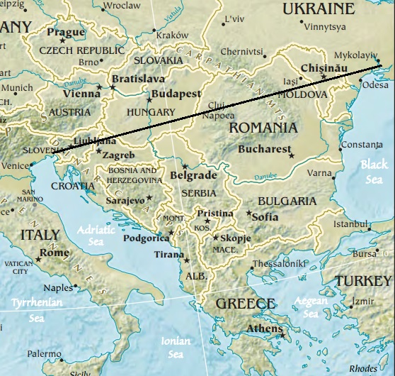
| Përshkrimi | Map of the Balkan peninsula, showing the line stretching from the northernmost point of the Adriatic to the northernmost point of the Black Sea. Made from Europe map at The Central Intelligence Agency World Factbook, which is in the public domain. |
| Burimi | https://www.cia.gov/library/publications/the-world-factbook//graphics/ref_maps/physical/jpg/europe.jpg |
| Autori | CIA |
| Versione tjera |
|
.jpg)
Licencim
This image is in the public domain because it contains materials that originally came from the United States Central Intelligence Agency's World Factbook.
|
 |

|
Kjo map fotografi duhet duhen te behen edhe i here si nje SVG.
|


Historiku skedës
Shtypni mbi një datë/kohë për ta parë skedën siç ishte atëherë.
| Data/Koha | Miniaturë | Përmasat | Përdoruesi | Koment | |
|---|---|---|---|---|---|
| e tanishme | 16 janar 2014 14:27 | | 558 × 530 (169 KB) | Denniss | Reverted to version as of 22:51, 26 December 2013 |
| 15 janar 2014 23:21 |  | 348 × 382 (43 KB) | Ivan VA | stop vandalizing maps | |
| 27 dhjetor 2013 00:51 |  | 558 × 530 (169 KB) | No More Cats | Please don't revert to outdated versions of maps | |
| 27 dhjetor 2013 00:43 |  | 348 × 382 (43 KB) | Nikola Smolenski | Reverted to version as of 19:13, 3 November 2006 | |
| 17 dhjetor 2013 18:06 |  | 558 × 530 (169 KB) | No More Cats | Map of the Balkan peninsula, showing the line stretching from the northernmost point of the Adriatic to the northernmost point of the Black Sea. Made from most recent map at [https://www.cia.gov/cia/publications/factbook/reference_maps/jpg/europe.jpg]. | |
| 3 nëntor 2006 21:13 |  | 348 × 382 (43 KB) | Nikola Smolenski | Map of the Balkan peninsula, showing the line stretching from the northernmost point of the Adriatic to the northernmost point of the Black Sea. Made from map at [https://www.cia.gov/cia/publications/factbook/reference_maps/jpg/europe.jpg]. |
Lidhje skedash
S’ka faqe që përdorin këtë kartelë.