
Skeda:Balkan states 1899.jpg

Dokument origjinal ((përmasa 937 × 1.417 px, madhësia skedës: 305 KB, lloji MIME: image/jpeg))
| Kjo skedë është prej Wikimedia Commons dhe mund të përdoret nga projekte të tjera. Përshkrimi në këtë skedë në këtë faqe nuk është treguar më poshtë. | Shko tek faqja përshkruese në Commons |
Përmbledhje
| Përshkrimi |
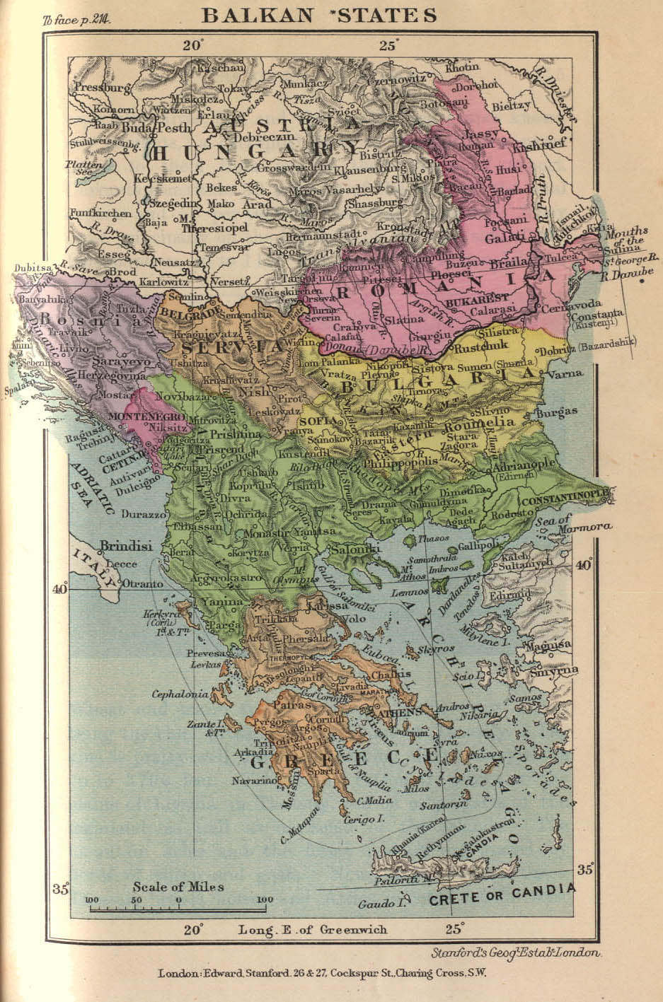
English: Balkan States 1899 (304K)
Map from "Stanford's Compendium of Geography and Travel: Europe" Volume 1, 1899. |
| Burimi |
http://www.lib.utexas.edu/maps/historical/balkan_states_1899.jpg
|
| Autori | Published by Edward Stanford |
Licencim
|
This work is in the public domain in its country of origin and other countries and areas where the copyright term is the author's life plus 70 years or fewer.
| |
| Kjo skedë është identifikuar si e lirë e kufizimeve të panjohura në ligjin e të drejtave të autorit, duke përfshirë të gjitha të drejtat e lidhura dhe fqinje. | |
Regjistri origjinal i ngarkimeve
- 2008-05-04 06:48 A.Cython 937×1417× (312073 bytes) {{Information |Description= Balkan States in 1899 |Source= Stanford's Compendium of Geography and Travel: Europe" Volume 1 |Date= 1899 |Author= |Permission= |other_versions= }}
- 2007-09-29 09:20 Jingiby 937×1417× (312073 bytes) Balkan States 1899 (304K) Map from "Stanford's Compendium of Geography and Travel: Europe" Volume 1, 1899. Source - [[http://www.lib.utexas.edu/maps/historical/balkan_states_1899.jpg]]
Historiku skedës
Shtypni mbi një datë/kohë për ta parë skedën siç ishte atëherë.
| Data/Koha | Miniaturë | Përmasat | Përdoruesi | Koment | |
|---|---|---|---|---|---|
| e tanishme | 15 nëntor 2008 19:41 | | 937 × 1.417 (305 KB) | File Upload Bot (Magnus Manske) | {{BotMoveToCommons|en.wikipedia}} {{Information |Description={{en|Balkan States 1899 (304K) Map from "Stanford's Compendium of Geography and Travel: Europe" Volume 1, 1899. Source - [[:en:http://www.lib.utexas.edu/maps/historical/balkan_states_1899.jpg |
Lidhje skedash
Këto faqe lidhen tek kjo skedë:
Përdorimi global i skedës
Kjo skedë përdoret nga Wiki të tjera në vijim:
- Përdorimi në bg.wikipedia.org
- Përdorimi në bs.wikipedia.org
- Përdorimi në en.wikipedia.org
- Përdorimi në es.wikipedia.org
- Përdorimi në et.wikipedia.org
- Përdorimi në fr.wikipedia.org
- Përdorimi në pt.wikipedia.org
- Përdorimi në sr.wikipedia.org
- Përdorimi në th.wikipedia.org