
Skeda:COVID-19 Outbreak Cases in Germany Kreise.svg

Dokument origjinal (skedë SVG, fillimisht 947 × 1.253 pixel, madhësia e skedës: 772 KB)
| Kjo skedë është prej Wikimedia Commons dhe mund të përdoret nga projekte të tjera. Përshkrimi në këtë skedë në këtë faqe nuk është treguar më poshtë. | Shko tek faqja përshkruese në Commons |
Përmbledhje
| Përshkrimi |
English: {|class="description en" lang="en" style="margin:0.5em auto;width:100%;border:1px solid #ABD5F5;background:white"
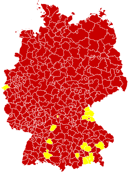
|+style="text-align:center;"|English (en): Map of the COVID-19 outbreak in Germany as of 14 March 2020. Be aware that since this is a rapidly evolving situation, new cases may not be immediately represented visually. Refer to the primary article 2019–20 coronavirus outbreak or the World Health Organization's situation reports for most recent reported case information. |- | Confirmed cases reported Especially affected areas (Besonders betroffene Gebiete), as defined by RKI
|} |
| Data | |
| Burimi |
Derived from File:Landkreise, Kreise und kreisfreie Städte in Deutschland 2011-09-04.svg by User:TUBS For full sources, see 2020 coronavirus outbreak in Germany#Timeline or COVID-19-Fälle in Deutschland#Verlauf; additionally current reliable media reports are incorporated - see change log of this file for details
|
| Autori | Smurrayinchester |
| SVG genesis |
Licencim
- Je i lirë të:
- ta shpërndani – ta kopjoni, rishpërndani dhe përcillni punën
- t’i bëni “remix” – të përshtatni punën
- Sipas kushteve të mëposhtme:
- atribuim – Duhet t’i jepni meritat e duhura, të siguroni një lidhje për tek licenca dhe të tregoni nëse janë bërë ndryshime. Këtë mund ta bëni në ndonjë mënyrë të arsyeshme, por jo në ndonjë mënyrë që sugjeron se licencuesi ju del zot juve apo përdorimit tuaj.
- share alike – Nëse bëni një “remix”, e shndërroni, ose ndërtoni duke u bazuar te materiali, duhet t’i shpërndani kontributet tuaja sipas të njëjtës licencë ose një të tille të përputhshme me origjinalen.
Historiku skedës
Shtypni mbi një datë/kohë për ta parë skedën siç ishte atëherë.
| Data/Koha | Miniaturë | Përmasat | Përdoruesi | Koment | |
|---|---|---|---|---|---|
| e tanishme | 30 mars 2020 18:13 | | 947 × 1.253 (772 KB) | LSE Wendland | Risikogebiete ergänzt |
| 21 mars 2020 11:25 |  | 947 × 1.253 (771 KB) | FelixL. | Updated: Zweibrücken, Pirmasens, Hildburghausen and Lüchow-Dannenberg | |
| 20 mars 2020 22:15 |  | 947 × 1.253 (761 KB) | FelixL. | New version now SVG | |
| 20 mars 2020 20:08 |  | 947 × 1.253 (706 KB) | Cush | Reverted to version as of 10:12, 18 March 2020 (UTC) The new files is not a real SVG but a PNG placed inside an SVG | |
| 20 mars 2020 17:30 |  | 947 × 1.253 (764 KB) | FelixL. | Updated (https://experience.arcgis.com/experience/478220a4c454480e823b17327b2bf1d4/page/page_1/) | |
| 18 mars 2020 12:12 |  | 947 × 1.253 (706 KB) | Smurrayinchester | Fill in some gaps using RKI data https://www.rki.de/DE/Content/InfAZ/N/Neuartiges_Coronavirus/Situationsberichte/2020-03-17-en.pdf?__blob=publicationFile | |
| 18 mars 2020 12:01 |  | 947 × 1.253 (706 KB) | Smurrayinchester | Update (+ LK Ansbach, Birkenfeld, Frankfurt (Oder), Gotha, Landau-Pfalz, Mittelsachsen, Mühldorf (Inn), Südwestpfalz, Trier-Saarburg, Unterallgäu, Unstrut-Hainich-Kreis, Wartburgkreis). Data for the NDR area has not been updated since Sunday | |
| 16 mars 2020 18:35 |  | 947 × 1.253 (705 KB) | Smurrayinchester | Update (+ Aischach-Friedberg, Amberg, Bamberg, Brandenburg (Havel), Dachau, Dessau-Roßlau, Eichsfeld, Eisenach, Greiz, Höxter, Jena, Kulmbach, Landau-in-der-Pfalz, Lichtenfels, Limburg-Weilburg, Odenwald, Regen, LK Stendal, Suhl, Unterallgäu, Weimarer Land, Werra-Meißner, Wunseidel i. Fichtelgebirge) | |
| 15 mars 2020 11:59 |  | 947 × 1.253 (705 KB) | Smurrayinchester | Update +(Altenkirchen (Westerwald), Darmstadt, Erlangen-Hochstadt, Kusel, Ludwigslust-Parchim, Nürnburg, Potsdam, Rhein-Hunsrück, Südliche Weinstraße, Tuttlingen, Würzburg). Not clear whether all states have updated over the weekend. | |
| 14 mars 2020 18:05 |  | 947 × 1.253 (705 KB) | Smurrayinchester | Update + Ahrweiler, Altenburger Land, Alzey-Worms, LK Aschaffenburg, Bad Kreuznach, Bad Tölz, Barnim, Cochem-Zell, Dahme-Spreewald, Eichstätt, Frankenthal (Pfalz), Gifhorn, Goslar, Hamm, Haßberge, Heidekreis, Helmstedt, Jerichower Land, Kaufbeuren, Krefeld, Kronach, Landshut (Stadt), Ludwigshafen (Rhein), Memmingen (Stadt), Miltenberg, LK Neustadt a.d.Waldnaab, Nordfriesland, Nordhausen, Nordsachsen, Northeim, Osnabrück (Stadt), Passau (Stadt), Potsdam-Mittelmark, Regen, Rhein-Pfalz, Rosenhei... |
Lidhje skedash
S’ka faqe që përdorin këtë kartelë.
Përdorimi global i skedës
Kjo skedë përdoret nga Wiki të tjera në vijim:
- Përdorimi në ar.wikipedia.org
- Përdorimi në fa.wikipedia.org
- Përdorimi në ja.wikipedia.org
- Përdorimi në uk.wikipedia.org
- Përdorimi në vi.wikipedia.org
- Përdorimi në www.wikidata.org