
Skeda:Czech Rep. - Bohemia, Moravia and Silesia III (en).png
Madhësia e këtij shikimi: 800 × 454 pixel. Rezolucione të tjera: 320 × 182 pixel | 640 × 364 pixel | 1.024 × 582 pixel | 1.280 × 727 pixel | 2.560 × 1.454 pixel | 3.852 × 2.188 pixel.
Dokument origjinal ((përmasa 3.852 × 2.188 px, madhësia skedës: 1,11 MB, lloji MIME: image/png))
| Kjo skedë është prej Wikimedia Commons dhe mund të përdoret nga projekte të tjera. Përshkrimi në këtë skedë në këtë faqe nuk është treguar më poshtë. | Shko tek faqja përshkruese në Commons |
.png)

|
Kjo historical map fotografi duhet duhen te behen edhe i here si nje SVG.
|
| Përshkrimi |
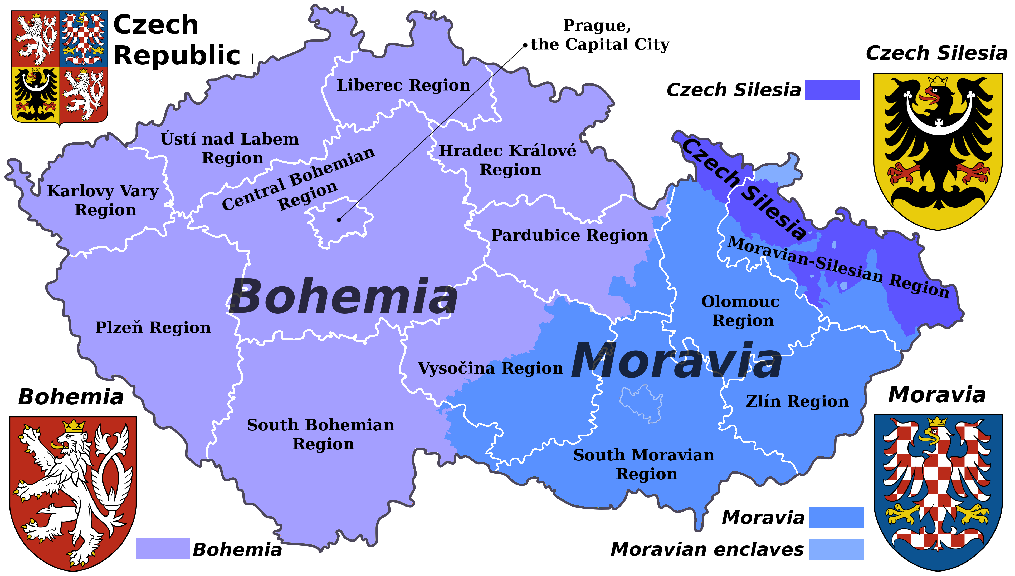
English: Map of the Czech republic showing the borders of its historical lands and the borders of the current administrative regions (kraje).
Čeština: Mapa České republiky s vyznačenými hranicemi krajů a historických zemí. |
| Data | (UTC) |
| Burimi | |
| Autori |
|
| This is a retouched picture, which means that it has been digitally altered from its original version. Modifications: Translated to English. The original can be viewed here: Czech Rep. - Bohemia, Moravia and Silesia III.png:
|
Unë, krijuesi i kësaj pune, e publikoj këtu në bazë të licensës në vijim:
Kjo skedë licencohet sipas Creative Commons Attribution-Share Alike 3.0 Unported.
- Je i lirë të:
- ta shpërndani – ta kopjoni, rishpërndani dhe përcillni punën
- t’i bëni “remix” – të përshtatni punën
- Sipas kushteve të mëposhtme:
- atribuim – Duhet t’i jepni meritat e duhura, të siguroni një lidhje për tek licenca dhe të tregoni nëse janë bërë ndryshime. Këtë mund ta bëni në ndonjë mënyrë të arsyeshme, por jo në ndonjë mënyrë që sugjeron se licencuesi ju del zot juve apo përdorimit tuaj.
- share alike – Nëse bëni një “remix”, e shndërroni, ose ndërtoni duke u bazuar te materiali, duhet t’i shpërndani kontributet tuaja sipas të njëjtës licencë ose një të tille të përputhshme me origjinalen.
Regjistri origjinal i ngarkimeve
This image is a derivative work of the following images:
- File:Czech_Rep._-_Bohemia,_Moravia_and_Silesia_III.png licensed with Cc-by-sa-3.0
- 2011-08-07T15:52:18Z Millenium187 3852x2188 (1393382 Bytes) {{Information |Description={{cs|Moderní verze historického znaku Moravy.}} {{cs| Moderní verze historického znaku Slezska.}}{{pl| Współczesna wersja herbu Czeskiego Śląska.}} |Source=*[[:File:Czech_Rep._-_Bohemia,_Mor
Uploaded with derivativeFX
Historiku skedës
Shtypni mbi një datë/kohë për ta parë skedën siç ishte atëherë.
| Data/Koha | Miniaturë | Përmasat | Përdoruesi | Koment | |
|---|---|---|---|---|---|
| e tanishme | 19 mars 2023 16:12 | | 3.852 × 2.188 (1,11 MB) | Moodylo333 | "Enclave" means: territory surrounded on '''all''' sides by the other territory |
| 29 shtator 2011 06:22 |  | 3.852 × 2.188 (1,11 MB) | Millenium187 | more pleasant colours | |
| 7 gusht 2011 21:38 |  | 3.852 × 2.188 (1,33 MB) | Millenium187 | {{Information |Description={{cs|Moderní verze historického znaku Moravy.}} {{cs| Moderní verze historického znaku Slezska.}}{{pl| Współczesna wersja herbu Czeskiego Śląska.}} |Source=*File:Czech_Rep._-_Bohemia,_Moravia_and_Silesia_III.png |D |
Lidhje skedash
Këto faqe lidhen tek kjo skedë:
Përdorimi global i skedës
Kjo skedë përdoret nga Wiki të tjera në vijim:
- Përdorimi në az.wikipedia.org
- Përdorimi në en.wikipedia.org
- Përdorimi në pt.wikipedia.org
- Përdorimi në uk.wikipedia.org
- Përdorimi në vi.wikipedia.org
.png)