
Skeda:Departements of French Empire South 1811-fr.svg

Size of this PNG preview of this SVG file: 697 × 600 pixel. Rezolucione të tjera: 279 × 240 pixel | 558 × 480 pixel | 892 × 768 pixel | 1.190 × 1.024 pixel | 2.379 × 2.048 pixel | 1.020 × 878 pixel.
Dokument origjinal (skedë SVG, fillimisht 1.020 × 878 pixel, madhësia e skedës: 235 KB)
| Kjo skedë është prej Wikimedia Commons dhe mund të përdoret nga projekte të tjera. Përshkrimi në këtë skedë në këtë faqe nuk është treguar më poshtë. | Shko tek faqja përshkruese në Commons |
Përmbledhje
| Përshkrimi |
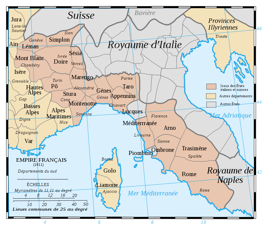
Français : Les départements du Sud du 1er Empire français (1811).
Attention: Cette carte est une carte historique. La qualité de sa précision ne permet pas une utilisation dans un contexte moderne.
English: French Departements of the South of the first Empire (1811)
Be careful: The map is an historical map. The precision is not sufficient for a modern use. |
| Data | |
| Burimi | Tiré d'une carte établie en 1811 par Messieurs Drioux et Leroy. |
| Autori | Ewan ar Born |
| Versione tjera |
|
| SVG genesis |


|
Kjo skedë SVG përdor tekst i cili mund të përkthehet fare lehtë në gjuhën tënde përmes [toolforge:svgtranslate/File:Departements_of_French_Empire_South_1811-fr.svglink këtij mjeti] në mënyrë automatike. Lexo më tepër. Gjithashtu ju mund ta shkarkoni këtë skedar dhe ta redaktoni manualisht përmes një tekst-editori. |
Licencim
| Unë,krijuesi i kësaj pune, e lëshoj këtë punë në public domain. Kjo aplikohet në të gjithë botën. Në disa vende kjo mund të mos jetë e mundur ligjërisht; nëse është kështu: Unë i garantoj çdokujt të drejtën për ta përdorur këtë punë për çdo qëllim, pa asnjë kusht, përveç rasteve kur këto kushte janë të kërkuara nga ligji. |
Historiku skedës
Shtypni mbi një datë/kohë për ta parë skedën siç ishte atëherë.
| Data/Koha | Miniaturë | Përmasat | Përdoruesi | Koment | |
|---|---|---|---|---|---|
| e tanishme | 28 korrik 2019 11:52 | | 1.020 × 878 (235 KB) | Augusta 89 | Demande à l'atelier cartographique (fr) : meilleur contraste entre les couleurs et correction de la couleur pour la Corse. |
| 30 gusht 2017 10:47 |  | 1.020 × 878 (236 KB) | Ras67 | cropped | |
| 29 shtator 2008 14:59 |  | 1.020 × 880 (287 KB) | Ewan ar Born | == Description == {{Information |Description={{fr|1=Les départements du Sud du 1er Empire français (1811). Attention: Cette carte est une carte historique. La qualité de sa précision ne permet pas une utilisation dans un contexte moderne.}} {{en|1=Fre |
Lidhje skedash
Përdorimi global i skedës
Kjo skedë përdoret nga Wiki të tjera në vijim:
- Përdorimi në ar.wikipedia.org
- Përdorimi në bg.wikipedia.org
- Përdorimi në br.wikipedia.org
- Përdorimi në ca.wikipedia.org
- Përdorimi në de.wikipedia.org
- Përdorimi në en.wikipedia.org
- Mont-Blanc (department)
- Apennins
- Arno (department)
- Doire
- Gênes
- Montenotte (department)
- Marengo (department)
- Stura
- Pô (department)
- Méditerranée
- Rome (department)
- Simplon (department)
- Taro (department)
- Trasimène
- Liamone
- Sésia
- Ombrone (department)
- Golo (department)
- Tanaro (department)
- Antoine-Marie Roederer
- History of Valais
- Përdorimi në eo.wikipedia.org
- Përdorimi në fr.wikipedia.org
Shikoni më shumë përdorim global të kësaj skede.