
Skeda:Hammurabi's Babylonia Locator Map 1.svg

Size of this PNG preview of this SVG file: 671 × 600 pixel. Rezolucione të tjera: 269 × 240 pixel | 537 × 480 pixel | 859 × 768 pixel | 1.146 × 1.024 pixel | 2.291 × 2.048 pixel | 744 × 665 pixel.
Dokument origjinal (skedë SVG, fillimisht 744 × 665 pixel, madhësia e skedës: 154 KB)
| Kjo skedë është prej Wikimedia Commons dhe mund të përdoret nga projekte të tjera. Përshkrimi në këtë skedë në këtë faqe nuk është treguar më poshtë. | Shko tek faqja përshkruese në Commons |
Përmbledhje
| Përshkrimi |
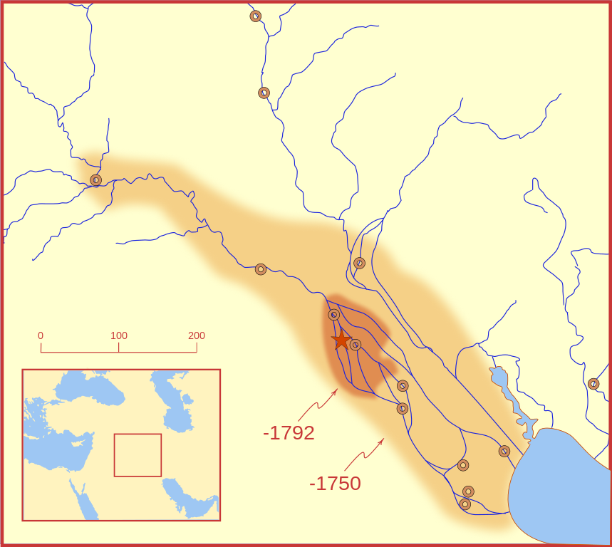
A locator map of Hammurabi's Babylonia, showing the Babylonian territory upon his ascension in 1792 BC and upon his death in 1750 BC. The river courses and coastline are those of that time period -- in general, they are not the modern rivers or coastlines. This is a Mercator projection, with north in its usual position. There is some question to what degree the cities of Nineveh, Tuttul, and Assur were under Babylonian authority. While in his introduction to his code of laws, Hammurabi claims lordship over these cities, Roaf does not include any of these in his map, upon which this map is based, and Chevalas states that "Assur and Nineveh were held for a very few years" (p. 155). Therefore, I have not included them as under Hammurabi's control in 1750 BC. |
| Data | |
| Burimi | Punë e juaja |
| Autori | MapMaster |
| Versione tjera |
[]
|


Other versions
References
- Bjorklund, Oddvar; Holmboe, Haakon; Rohr, Anders (1970) Historical Atlas of the World, Barnes & Noble, NY, SBN: 389-00253-4.
- Chavalas, Mark W.; K. Lawson Younger (2003) Mesopotamia and the Bible, Continuum International Publishing Group, ISBN 978-0567082312.
- Hammond World Atlas Corporation (2007) Historical World Atlas, ISBN 9-780843-71391-6
- Roaf, M. (1990) Cultural Atlas of Mesopotamia and the ancient Near East, Oxford: Facts on File. (In general, the basis for the ancient river courses and ancient coastline).
- Van De Mieroop, Marc (2005). King Hammurabi of Babylon: A Biography. Blackwell Publishing. ISBN 1405126604
Licencim
Unë, krijuesi i kësaj pune, e publikoj këtu në bazë të licensës në vijim:

|
Ju jepet leje për ta kopjuar, shpërndarë dhe/ose ndryshuar këtë dokument sipas kushteve të Licencës GNU për Dokumentim të Lirë, versioni 1.2 ose çfarëdo versioni të mëpasshëm të botuar nga Free Software Foundation; pa Seksione të Pandryshueshme, pa Tekste Kapakësh të Përparmë, dhe pa Tekste Kapakësh të Pasmë. Një kopje e kësaj licence është përfshirë në seksionin e titulluar GNU Free Documentation License. |
This file is licensed under the Creative Commons Attribution-Share Alike 4.0 International, 3.0 Unported, 2.5 Generic, 2.0 Generic and 1.0 Generic license.
- Je i lirë të:
- ta shpërndani – ta kopjoni, rishpërndani dhe përcillni punën
- t’i bëni “remix” – të përshtatni punën
- Sipas kushteve të mëposhtme:
- atribuim – Duhet t’i jepni meritat e duhura, të siguroni një lidhje për tek licenca dhe të tregoni nëse janë bërë ndryshime. Këtë mund ta bëni në ndonjë mënyrë të arsyeshme, por jo në ndonjë mënyrë që sugjeron se licencuesi ju del zot juve apo përdorimit tuaj.
- share alike – Nëse bëni një “remix”, e shndërroni, ose ndërtoni duke u bazuar te materiali, duhet t’i shpërndani kontributet tuaja sipas të njëjtës licencë ose një të tille të përputhshme me origjinalen.
Mundeni të përzgjidhni licencën që doni.
Historiku skedës
Shtypni mbi një datë/kohë për ta parë skedën siç ishte atëherë.
| Data/Koha | Miniaturë | Përmasat | Përdoruesi | Koment | |
|---|---|---|---|---|---|
| e tanishme | 21 shkurt 2008 05:26 | | 744 × 665 (154 KB) | MapMaster | "blurred" the territory outlines |
| 21 shkurt 2008 01:22 |  | 744 × 665 (149 KB) | MapMaster | Changes based on a review of ''Mesopotamia and the Bible'' | |
| 21 shkurt 2008 00:10 |  | 744 × 665 (151 KB) | MapMaster | Minor edits | |
| 19 shkurt 2008 05:03 |  | 744 × 665 (150 KB) | MapMaster | Once more, with feeling | |
| 19 shkurt 2008 04:09 |  | 744 × 665 (151 KB) | MapMaster | earlier upload would not render | |
| 19 shkurt 2008 04:01 |  | 332 × 292 (333 KB) | MapMaster | {{Information |Description=A locator map of Hammurabi's Babylonia, showing the Babylonian territory upon his ascension in 1792 BC and upon his death in 1750 BC. The river courses and coastline are those of that time period -- in general, they are not the |
Lidhje skedash
Këto faqe lidhen tek kjo skedë:
Përdorimi global i skedës
Kjo skedë përdoret nga Wiki të tjera në vijim:
- Përdorimi në bg.wikipedia.org
- Përdorimi në bs.wikipedia.org
- Përdorimi në cs.wikipedia.org
- Përdorimi në da.wikipedia.org
- Përdorimi në el.wikipedia.org
- Përdorimi në eo.wikipedia.org
- Përdorimi në et.wikipedia.org
- Përdorimi në fi.wikipedia.org
- Përdorimi në fr.wikipedia.org
- Përdorimi në gl.wikipedia.org
- Përdorimi në he.wikipedia.org
- Përdorimi në hr.wikipedia.org
- Përdorimi në hu.wikipedia.org
- Përdorimi në id.wikipedia.org
- Përdorimi në it.wikipedia.org
- Përdorimi në ja.wikipedia.org
- Përdorimi në jv.wikipedia.org
- Përdorimi në lt.wikipedia.org
- Përdorimi në lv.wikipedia.org
- Përdorimi në nl.wikipedia.org
- Përdorimi në no.wikipedia.org
- Përdorimi në pl.wikipedia.org
- Përdorimi në pt.wikipedia.org
- Përdorimi në ro.wikipedia.org
- Përdorimi në ru.wikipedia.org
- Përdorimi në sh.wikipedia.org
- Përdorimi në sl.wikipedia.org
- Përdorimi në sv.wikipedia.org
- Përdorimi në sw.wikipedia.org
- Përdorimi në tr.wikipedia.org