
Skeda:Hellenism in the Near East 1918.jpg
Madhësia e këtij shikimi: 489 × 600 pixel. Rezolucione të tjera: 196 × 240 pixel | 391 × 480 pixel | 626 × 768 pixel | 835 × 1.024 pixel | 1.403 × 1.721 pixel.
Dokument origjinal ((përmasa 1.403 × 1.721 px, madhësia skedës: 862 KB, lloji MIME: image/jpeg))
| Kjo skedë është prej Wikimedia Commons dhe mund të përdoret nga projekte të tjera. Përshkrimi në këtë skedë në këtë faqe nuk është treguar më poshtë. | Shko tek faqja përshkruese në Commons |
Përmbledhje
| Përshkrimi |
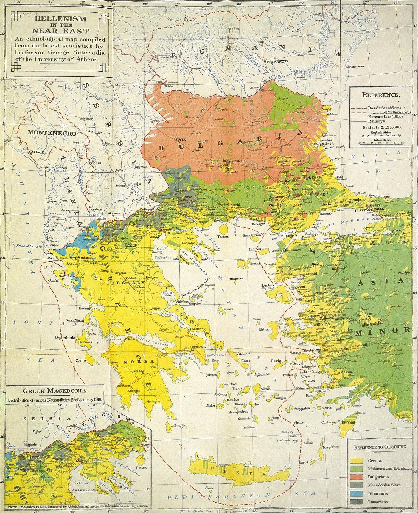
العربية: المملكة اليونانية وانتشار اليونان في البلقان وغربي آسيا الصغرى وفقًا لخريطة من عام 1919 قدمها المفوضين اليونان إلى مؤتمر السلام في باريس.
English: "...The present map, on the other hand, takes not language, but national conciousness as the only satisfactory criterion of nationality..." - The original, detailed explanation from the publisher of the map is exposed here. Important factor: the map shows the population, as it was before the 1923-1930 population exchange processs, and before migrations caused by the Greek civil war. The map recognizes the "Macedonian Slavs" nationality, as a separate one, non-Bulgarian.
Polski: Niniejsza mapa nie przedstawia zasięgu używanych języków, a koncentruje się na samookreśleniu świadomości narodowej, stwierdzonej w poszczególnych grupach ludności. I tak np. autor do Greków zaliczył Wlachów (lokalne określenie greckich Arumunów), podczas gdy mówiących podobnym językiem Kucowołochów, nie uważających się za Greków, autor zaliczył do narodowości rumuńskiej. Podobnie geckich Arwanitów z Attyki czy Peloponezu zaliczono do narodowości greckiej - mimo języka zbliżonego do albańskiego, należeli oni, już od wielkiego powstania 1821, do najbardziej państwotwórczych czynników nowożytnej Grecji. Podczas gdy Czamów autor zaliczył do narodowości Albańskiej, z uwagi na takie ich samookreślanie się. Mapa dokumentuje też istnienie poczucia odrębności narodowej "Macedońskich Słowian", odróżniając ich od "Bułgarów". Oryginalne, szczegółowe wyjaśnienia od wydawcy mapy, czytelnik znajdzie tutaj |
| Burimi | “An Ethnological Map Illustrating Hellenism In The Balkan Peninsula And Asia Minor” |
| Autori | George Soteriadis, 1852-1942, Professor of History at the University of Athens |
| Leja (Ripërdor këtë skedë) |
"London: Edward Stanford, LTD. 12, 13, 14 Long Acre, W.C.2. 1918" |
Licencim
|
The author died in 1942, so this work is in the public domain in its country of origin and other countries and areas where the copyright term is the author's life plus 80 years or fewer. This work is in the public domain in the United States because it was published (or registered with the U.S. Copyright Office) before January 1, 1929. | |
| Kjo skedë është identifikuar si e lirë e kufizimeve të panjohura në ligjin e të drejtave të autorit, duke përfshirë të gjitha të drejtat e lidhura dhe fqinje. | |
Regjistri origjinal i ngarkimeve
The original description page was here. All following user names refer to en.wikipedia.
- 2010-04-05 17:54 Beao 1403×1721× (882530 bytes)
- 2008-05-18 22:18 Mactruth 1444×1749× (757962 bytes) Author: George Soteriadis Professor of History at the University of Athens Book Title: “An Ethnological Map Illustrating Hellenism In The Balkan Peninsula And Asia Minor” Source/Copyright: "London: Edward Stanford, LTD. 12, 13, 14 Long Acre, W.C.2. 1
Historiku skedës
Shtypni mbi një datë/kohë për ta parë skedën siç ishte atëherë.
| Data/Koha | Miniaturë | Përmasat | Përdoruesi | Koment | |
|---|---|---|---|---|---|
| e tanishme | 17 nëntor 2011 03:33 | | 1.403 × 1.721 (862 KB) | OgreBot | (BOT): Reverting to most recent version before archival |
| 17 nëntor 2011 03:33 |  | 1.444 × 1.749 (740 KB) | OgreBot | (BOT): Uploading old version of file from en.wikipedia; originally uploaded on 2008-05-18 22:18:46 by Mactruth | |
| 30 mars 2011 09:43 |  | 1.403 × 1.721 (862 KB) | Khutuck Bot | {{BotMoveToCommons|tr.wikipedia|year={{subst:CURRENTYEAR}}|month={{subst:CURRENTMONTHNAME}}|day={{subst:CURRENTDAY}}}} {{Information |Description={{tr|== Lisanslama ==}} |Source=Transferred from [http://tr.wikipedia.org tr.wikipedia] |Date={{Date|2010|0 | |
| 20 mars 2008 11:26 |  | 1.444 × 1.749 (740 KB) | JulienMarque | {{Information |Description=Hellenism in the Near East |Source="An Ethnological Map Illustrating Hellenism in the Balkan Peninsula and Asia Minor", Edward Stanford, London |Date=1918 |Author=George Soteriadis |Permission={{PD-old}} }} |
Lidhje skedash
S’ka faqe që përdorin këtë kartelë.
Përdorimi global i skedës
Kjo skedë përdoret nga Wiki të tjera në vijim:
- Përdorimi në ar.wikipedia.org
- Përdorimi në azb.wikipedia.org
- Përdorimi në be.wikipedia.org
- Përdorimi në bg.wikipedia.org
- Përdorimi në ca.wikipedia.org
- Përdorimi në cs.wikipedia.org
- Përdorimi në de.wikipedia.org
- Përdorimi në el.wikipedia.org
- Përdorimi në en.wikipedia.org
- History of modern Greece
- Macedonians (ethnic group)
- Demographic history of Macedonia
- Greco-Turkish War (1919–1922)
- Greek genocide
- History of modern Macedonia (Greece)
- Greeks in Turkey
- Macedonia naming dispute
- Slavic speakers of Greek Macedonia
- Ottoman Greeks
- File:Ethnological.jpg
- Wikipedia:Reference desk/Archives/Humanities/2019 March 30
- User:Falcaorib
- Përdorimi në eo.wikipedia.org
- Përdorimi në eu.wikipedia.org
- Përdorimi në fi.wikipedia.org
- Përdorimi në fr.wikipedia.org
- Përdorimi në hu.wikipedia.org
- Përdorimi në hy.wikipedia.org
- Përdorimi në id.wikipedia.org
- Përdorimi në it.wikipedia.org
- Përdorimi në ja.wikipedia.org
- Përdorimi në nl.wikipedia.org
- Përdorimi në pnb.wikipedia.org
- Përdorimi në pt.wikipedia.org
- Përdorimi në ro.wikipedia.org
- Përdorimi në ru.wikipedia.org
- Përdorimi në sr.wikipedia.org
- Përdorimi në tr.wikipedia.org
- Përdorimi në uk.wikipedia.org
- Përdorimi në ur.wikipedia.org
- Përdorimi në zh.wikipedia.org