
Skeda:Karta över de europeiska delarna av Sovjetunionen på 1920-talet.jpg

Madhësia e këtij shikimi: 439 × 600 pixel. Rezolucione të tjera: 176 × 240 pixel | 351 × 480 pixel | 562 × 768 pixel | 750 × 1.024 pixel | 2.548 × 3.480 pixel.
Dokument origjinal ((përmasa 2.548 × 3.480 px, madhësia skedës: 1,81 MB, lloji MIME: image/jpeg))
| Kjo skedë është prej Wikimedia Commons dhe mund të përdoret nga projekte të tjera. Përshkrimi në këtë skedë në këtë faqe nuk është treguar më poshtë. | Shko tek faqja përshkruese në Commons |
Përmbledhje
| Përshkrimi |
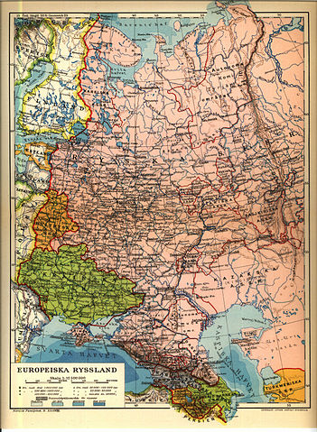
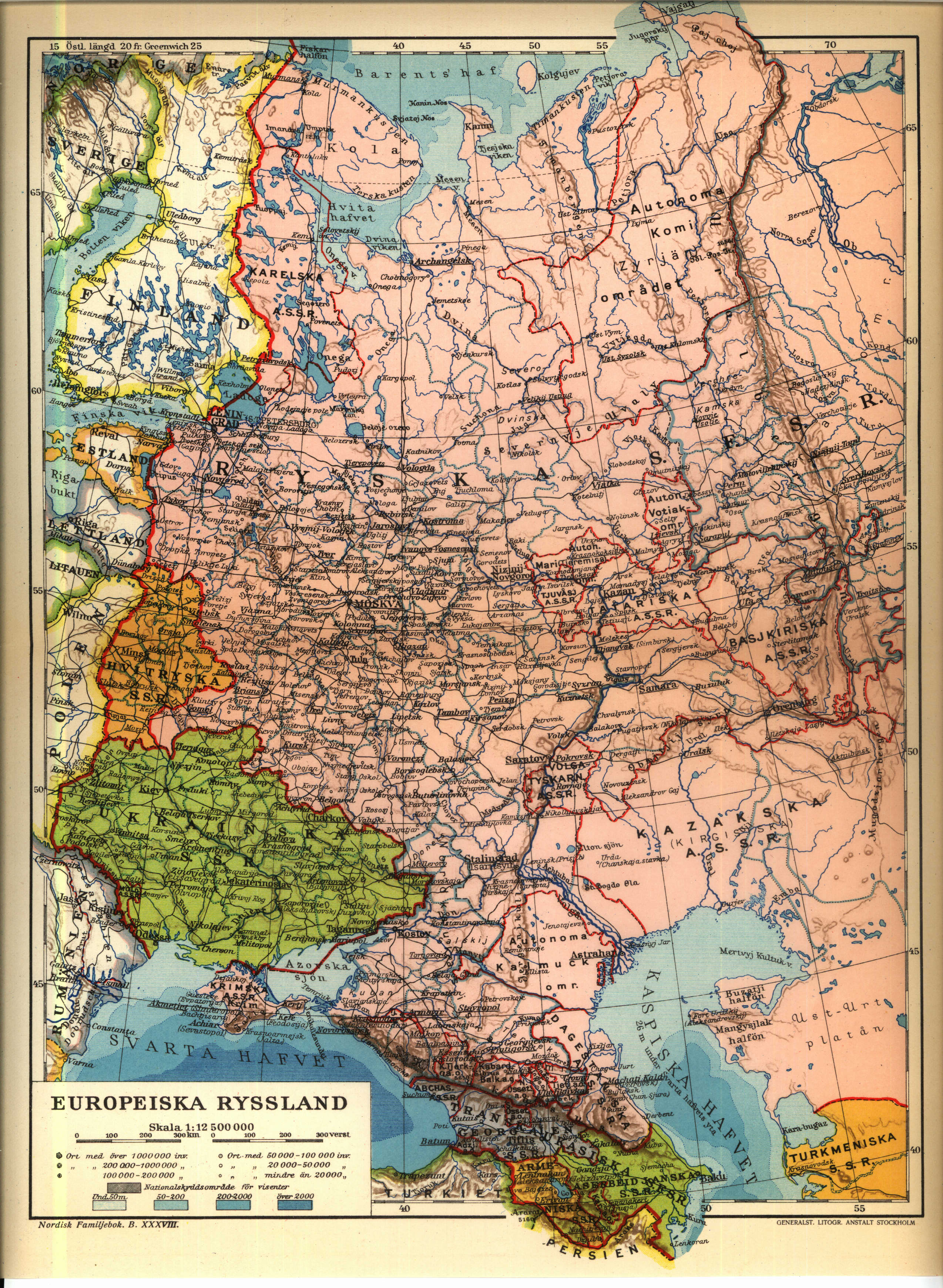
English: 1926 Map of the western Soviet Union region.
Norsk bokmål: från Nordisk familjebok |
||||||||
| Burimi | https://runeberg.org/nfcr/ryssland.jpg | ||||||||
| Autori | User Den fjättrade ankan on sv.wikipedia | ||||||||
| Leja (Ripërdor këtë skedë) |
|
||||||||
| Versione tjera |
Derivative works of this file: Karta över de europeiska delarna av Sovjetunionen på 1920-talet Georgiska SSR.jpg, Derivative works of this file: Kaninhalvön.jpg Originally from sv.wikipedia; description page is (was) here * 25 juni 2004 kl.01.54 [[:sv:User:Den fjättrade ankan|Den fjättrade ankan]] 2548x3480 (1 899 294 bytes) <span class="comment">(från Nordisk familjebok)</span> |


(Uploaded using CommonsHelper or PushForCommons)
sv:Kategori:Kartor från Nordisk familjebok
Historiku skedës
Shtypni mbi një datë/kohë për ta parë skedën siç ishte atëherë.
| Data/Koha | Miniaturë | Përmasat | Përdoruesi | Koment | |
|---|---|---|---|---|---|
| e tanishme | 7 korrik 2006 00:24 | | 2.548 × 3.480 (1,81 MB) | Nicke L | {{Information| |Description= från Nordisk familjebok sv:Kategori:Kartor från Nordisk familjebok |Source= |Date= |Author=User Den fjättrade ankan on [http://sv.wikipedia.org sv.wikipedia] |Permission={{Ugglanbild} |
Lidhje skedash
Këto faqe lidhen tek kjo skedë:
Përdorimi global i skedës
Kjo skedë përdoret nga Wiki të tjera në vijim:
- Përdorimi në be-tarask.wikipedia.org
- Përdorimi në be.wikipedia.org
- Përdorimi në ca.wikipedia.org
- Përdorimi në cs.wikipedia.org
- Përdorimi në de.wikipedia.org
- Përdorimi në en.wikipedia.org
- Përdorimi në fi.wikipedia.org
- Përdorimi në fr.wikipedia.org
- Përdorimi në ru.wikipedia.org
- Përdorimi në sk.wikipedia.org
- Përdorimi në sr.wikipedia.org
- Përdorimi në tg.wikipedia.org
- Përdorimi në uk.wikipedia.org