
Skeda:Mallnitz Stappitz Ankogel-Panorama 01.jpg

Madhësia e këtij shikimi: 800 × 270 pixel. Rezolucione të tjera: 320 × 108 pixel | 640 × 216 pixel | 1.024 × 346 pixel | 1.280 × 432 pixel | 2.560 × 864 pixel | 13.236 × 4.468 pixel.
Dokument origjinal ((përmasa 13.236 × 4.468 px, madhësia skedës: 44,93 MB, lloji MIME: image/jpeg))
| Kjo skedë është prej Wikimedia Commons dhe mund të përdoret nga projekte të tjera. Përshkrimi në këtë skedë në këtë faqe nuk është treguar më poshtë. | Shko tek faqja përshkruese në Commons |
| Warning | The original file is very high-resolution. It might not load properly or could cause your browser to freeze when opened at full size. |
|---|
Përmbledhje
| Përshkrimi |
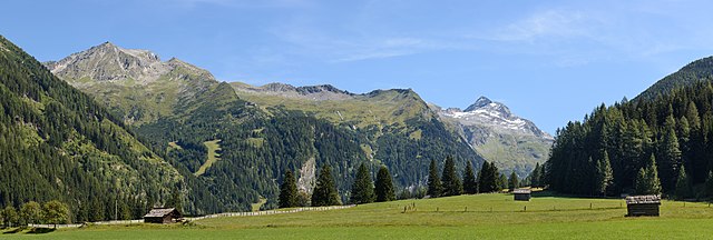
Deutsch: Ankogel (3252 m) im Nationalpark Hohe Tauern – Ansicht von Stappitz im Seebachtal bei Mallnitz, Kärnten, Österreich
English: Ankogel (3,252 metres (10,669 ft)) in the High Tauern National Park – view from Stappitz in the Seebach Valley near Mallnitz, Carinthia, Austria
Čeština: Hora Ankogel (3 252 m n.m.) v pohoří Vysoké Taury v Rakousku, pohled z místa Stappitz v údolí Seebach.
Español: Vista del Ankogel (3252 metros) en el parque nacional Hohe Tauern, desde Stappitz en el valle de Seebach, cerca de Mallnitz, Carintia, Austria.
Magyar: Az Ankogel (3252 m) látképe a Magas-Tauern Nemzeti Parkban a Stappitz felől a Seebach-völgyben (Mallnitz, Karintia, Ausztria)
Македонски: Планината Анкогел (3.252 м) во венецот Високи Таури гледана од долината кај Малниц во Корушка, Австрија.
Эрзянь: Ankogel пандось (3,252 metres (10,669 ft)) Сэрей Тауэрн раськень вирьпусмосо Зеебахской лаймесэ, Каринтия, Австрия.
Português: Montanha Ankogel (3 252 metros) no parque nacional do Alto Tauern, visto do Stappitz no vale de Seebach, perto de Mallnitz, Caríntia, Áustria
|
|||
| Data | ||||
| Burimi | Punë e juaja | |||
| Autori | Uoaei1 |

| Camera location | | View this and other nearby images on: OpenStreetMap |
|---|

|
NOTE: This image is a panorama consisting of multiple frames that were merged or stitched in software. As a result, this image necessarily underwent some form of digital manipulation. These manipulations may include blending, blurring, cloning, and colour and perspective adjustments. As a result of these adjustments, the image content may be slightly different from reality at the points where multiple images were combined. This manipulation is often required due to lens, perspective, and parallax distortions.
|
|
The making of this work was supported by Wikimedia Austria. For other files made with the support of Wikimedia Austria, please see the category Supported by Wikimedia Österreich. |
Assessment
This image was selected as picture of the day on Wikimedia Commons for 14 August 2019. It was captioned as follows: English: Ankogel (3,252 metres (10,669 ft)) in the High Tauern National Park – view from Stappitz in the Seebach Valley near Mallnitz, Carinthia, Austria Other languages:
Čeština: Hora Ankogel (3 252 m n.m.) v pohoří Vysoké Taury v Rakousku, pohled z místa Stappitz v údolí Seebach. Deutsch: Ankogel (3252 m) im Nationalpark Hohe Tauern – Ansicht von Stappitz im Seebachtal bei Mallnitz, Kärnten, Österreich English: Ankogel (3,252 metres (10,669 ft)) in the High Tauern National Park – view from Stappitz in the Seebach Valley near Mallnitz, Carinthia, Austria Español: Vista del Ankogel (3252 metros) en el parque nacional Hohe Tauern, desde Stappitz en el valle de Seebach, cerca de Mallnitz, Carintia, Austria. Magyar: Az Ankogel (3252 m) látképe a Magas-Tauern Nemzeti Parkban a Stappitz felől a Seebach-völgyben (Mallnitz, Karintia, Ausztria) Português: Montanha Ankogel (3 252 metros) no parque nacional do Alto Tauern, visto do Stappitz no vale de Seebach, perto de Mallnitz, Caríntia, Áustria Македонски: Планината Анкогел (3.252 м) во венецот Високи Таури гледана од долината кај Малниц во Корушка, Австрија. |
|
Ky imazh është vlerësuar duke përdorur udhëzimet imazheve cilësore dhe konsiderohet një imazh cilësor.
|
Licencim
Unë, krijuesi i kësaj pune, e publikoj këtu në bazë të licensës në vijim:
This file is licensed under the Creative Commons Attribution-Share Alike 4.0 International license.
- Je i lirë të:
- ta shpërndani – ta kopjoni, rishpërndani dhe përcillni punën
- t’i bëni “remix” – të përshtatni punën
- Sipas kushteve të mëposhtme:
- atribuim – Duhet t’i jepni meritat e duhura, të siguroni një lidhje për tek licenca dhe të tregoni nëse janë bërë ndryshime. Këtë mund ta bëni në ndonjë mënyrë të arsyeshme, por jo në ndonjë mënyrë që sugjeron se licencuesi ju del zot juve apo përdorimit tuaj.
- share alike – Nëse bëni një “remix”, e shndërroni, ose ndërtoni duke u bazuar te materiali, duhet t’i shpërndani kontributet tuaja sipas të njëjtës licencë ose një të tille të përputhshme me origjinalen.

|
Diese Datei wurde im Rahmen von WikiDaheim 2017 in Österreich erstellt und hochgeladen. Sie wurde dem Themenbereich Naturschutz zugeordnet. |
| Annotations | This image is annotated: View the annotations at Commons |
Historiku skedës
Shtypni mbi një datë/kohë për ta parë skedën siç ishte atëherë.
| Data/Koha | Miniaturë | Përmasat | Përdoruesi | Koment | |
|---|---|---|---|---|---|
| e tanishme | 15 gusht 2017 10:22 | 13.236 × 4.468 (44,93 MB) | Uoaei1 | User created page with UploadWizard |
Lidhje skedash
Këto faqe lidhen tek kjo skedë:
Përdorimi global i skedës
Kjo skedë përdoret nga Wiki të tjera në vijim:
- Përdorimi në be-tarask.wikipedia.org
- Përdorimi në bn.wikipedia.org
- Përdorimi në crh.wikipedia.org
- Përdorimi në cv.wikipedia.org
- Përdorimi në de.wikipedia.org
- Përdorimi në en.wikipedia.org
- Përdorimi në fr.wikipedia.org
- Përdorimi në hu.wikipedia.org
- Përdorimi në hy.wikipedia.org
- Përdorimi në ka.wikipedia.org
- Përdorimi në ko.wikipedia.org
- Përdorimi në lbe.wikipedia.org
- Përdorimi në lez.wikipedia.org
- Përdorimi në mk.wikipedia.org
- Përdorimi në os.wikipedia.org
- Përdorimi në pfl.wikipedia.org
- Përdorimi në pt.wikipedia.org
- Përdorimi në ru.wikipedia.org
- Përdorimi në ru.wikinews.org
- Përdorimi në sah.wikipedia.org
- Përdorimi në tt.wikipedia.org
- Përdorimi në uk.wikipedia.org
- Përdorimi në vep.wikipedia.org
- Përdorimi në zh.wikipedia.org