
Skeda:Map of Jewish settlements in Palestine in 1947.png
Nuk ka përmasa më të madhaja.
Map_of_Jewish_settlements_in_Palestine_in_1947.png ((përmasa 312 × 556 px, madhësia skedës: 59 KB, lloji MIME: image/png))
| Kjo skedë është prej Wikimedia Commons dhe mund të përdoret nga projekte të tjera. Përshkrimi në këtë skedë në këtë faqe nuk është treguar më poshtë. | Shko tek faqja përshkruese në Commons |
Përmbledhje
| Përshkrimi |
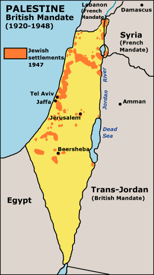
English: Map of Jewish settlements in Palestine in 1947. |
| Data | 2 tetor 2003 (original upload date) |
| Burimi | Transferred from en.wikipedia to Commons using CommonsHelper. |
| Autori | JamesDay at anglisht Wikipedia |
| Leja (Ripërdor këtë skedë) |
GFDL derivative work created by the uploader based on a portion of the public domain work http://www.lib.utexas.edu/maps/historical/israel_hist_1973.jpg . At http://www.lib.utexas.edu/maps/faq.html that site states that "Most of the maps scanned by the General Libraries and served from this web site are in the public domain. No permissions are needed to copy them. You may download them and use them as you wish. A few maps are copyrighted, and are clearly marked as such". There is no such mark with this map, so it is presumed to have been in the public domain before the derivative work was created. The uploader hereby releases the derivative work under the GFDL. |
Licencim

|
Ju jepet leje për ta kopjuar, shpërndarë dhe/ose ndryshuar këtë dokument sipas kushteve të Licencës GNU për Dokumentim të Lirë, versioni 1.2 ose çfarëdo versioni të mëpasshëm të botuar nga Free Software Foundation; pa Seksione të Pandryshueshme, pa Tekste Kapakësh të Përparmë, dhe pa Tekste Kapakësh të Pasmë. Një kopje e kësaj licence është përfshirë në seksionin e titulluar GNU Free Documentation License. |
| Kjo skedë licencohet sipas Creative Commons Attribution-Share Alike 3.0 Unported. | ||
| Atribuim: Wikipedia user JamesDay | ||
| ||
| Kjo etiketë licencimi u shtua te kjo skedë si pjesë e përditësimit të lincecimit. GFDL. |
Regjistri origjinal i ngarkimeve
The original description page was here. All following user names refer to en.wikipedia.
- 2005-09-27 18:47 Doviende 312×556× (60723 bytes) changed from indexed colour to RGB and traced the lines again so they aren't so choppy. Also redid all the text so it's anti-aliased better.
- 2003-10-02 14:18 JamesDay 312×556× (11422 bytes) Map of Jewish settlements in Palestine in 1947.
Historiku skedës
Shtypni mbi një datë/kohë për ta parë skedën siç ishte atëherë.
| Data/Koha | Miniaturë | Përmasat | Përdoruesi | Koment | |
|---|---|---|---|---|---|
| e tanishme | 18 dhjetor 2006 18:13 | | 312 × 556 (59 KB) | Electionworld | {{ew|en|JamesDay}} Map of Jewish settlements in Palestine in 1947. Copyright: GFDL derivative work created by the uploader based on a portion of the public domain work http://www.lib.utexas.edu/maps/historical/israel_hist_1973.jpg . At http://www.lib.ute |
Lidhje skedash
Këto faqe lidhen tek kjo skedë:
Përdorimi global i skedës
Kjo skedë përdoret nga Wiki të tjera në vijim:
- Përdorimi në als.wikipedia.org
- Përdorimi në ast.wikipedia.org
- Përdorimi në de.wikipedia.org
- Përdorimi në en.wikipedia.org
- Përdorimi në es.wikipedia.org
- Përdorimi në fi.wikipedia.org
- Përdorimi në gl.wikipedia.org
- Përdorimi në it.wikipedia.org
- Përdorimi në stq.wikipedia.org