
Skeda:Namibia map.png
Nuk ka përmasa më të madhaja.
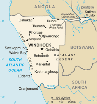
Namibia_map.png ((përmasa 326 × 349 px, madhësia skedës: 19 KB, lloji MIME: image/png))
| Kjo skedë është prej Wikimedia Commons dhe mund të përdoret nga projekte të tjera. Përshkrimi në këtë skedë në këtë faqe nuk është treguar më poshtë. | Shko tek faqja përshkruese në Commons |
CIA map of Namibia
- See also the 2004 version.
.png)
This image is in the public domain because it contains materials that originally came from the United States Central Intelligence Agency's World Factbook.
|
 |
derivative works
Derivative works of this file: Namibia map-sv.png
Historiku skedës
Shtypni mbi një datë/kohë për ta parë skedën siç ishte atëherë.
| Data/Koha | Miniaturë | Përmasat | Përdoruesi | Koment | |
|---|---|---|---|---|---|
| e tanishme | 17 janar 2022 12:17 | | 326 × 349 (19 KB) | Lojwe | Cropped 1 % horizontally, 1 % vertically using CropTool with precise mode. |
| 21 korrik 2007 09:59 |  | 328 × 353 (20 KB) | Hoshie | Updated map of Namibia from the CIA World Factbook, 14 June 07 rev. Src: https://www.cia.gov/library/publications/the-world-factbook/maps/wa-map.gif | |
| 4 mars 2005 22:51 |  | 330 × 355 (9 KB) | Alfio | CIA map of Namibia |
Lidhje skedash
Këto faqe lidhen tek kjo skedë:
Përdorimi global i skedës
Kjo skedë përdoret nga Wiki të tjera në vijim:
- Përdorimi në af.wikipedia.org
- Përdorimi në ar.wikipedia.org
- Përdorimi në bg.wikipedia.org
- Përdorimi në ca.wikipedia.org
- Përdorimi në da.wikipedia.org
- Përdorimi në de.wikipedia.org
- Përdorimi në dsb.wikipedia.org
- Përdorimi në en.wikipedia.org
- Përdorimi në fi.wikipedia.org
- Përdorimi në fr.wikipedia.org
- Përdorimi në hif.wikipedia.org
- Përdorimi në hr.wikipedia.org
- Përdorimi në hu.wikipedia.org
- Përdorimi në hu.wiktionary.org
- Përdorimi në incubator.wikimedia.org
- Përdorimi në it.wikipedia.org
- Përdorimi në ja.wikipedia.org
- Përdorimi në ka.wikipedia.org
- Përdorimi në kg.wikipedia.org
- Përdorimi në kn.wikipedia.org
Shikoni më shumë përdorim global të kësaj skede.