
Skeda:Roman expansion 264 BC Shepherd.jpg

Dokument origjinal ((përmasa 2.302 × 1.812 px, madhësia skedës: 873 KB, lloji MIME: image/jpeg))
| Kjo skedë është prej Wikimedia Commons dhe mund të përdoret nga projekte të tjera. Përshkrimi në këtë skedë në këtë faqe nuk është treguar më poshtë. | Shko tek faqja përshkruese në Commons |
This image was copied from wikipedia:de. The original description was:
| Përshkrimi |
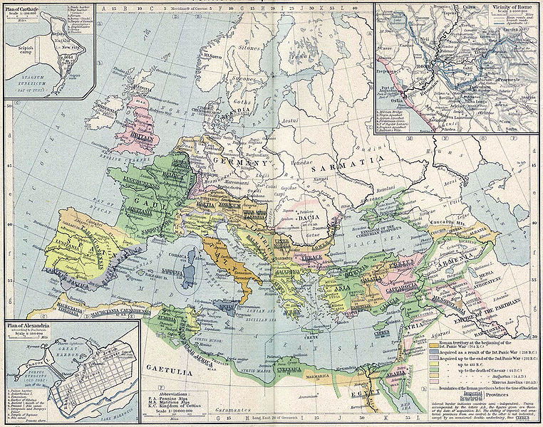
English: Roman territory, from the beginning of the 1st punic war (264 B.C.) to the death of Diocletian
Deutsch: Römisches Reich vom Beginn des 1. Punischen Kriegs (264 v.Chr.) bis zum Tod von Diokletian (312) im Historischen Atlas von William R. Shepherd (1923) |
| Data | 1923 |
| Burimi | "Historical Atlas" by William R. Shepherd, New York, Henry Holt and Company |
| Autori | William R. Shepherd |
| Versione tjera |
|
This work is in the public domain in its country of origin and other countries and areas where the copyright term is the author's life plus 70 years or fewer.
| |
| Kjo skedë është identifikuar si e lirë e kufizimeve të panjohura në ligjin e të drejtave të autorit, duke përfshirë të gjitha të drejtat e lidhura dhe fqinje. | |
| date/time | username | edit summary |
|---|---|---|
| 18:08, 21. Feb 2005 | Benowar | ("Historical Atlas" by William R. Shepherd, New York, Henry Holt and Company, 1923 PUBLIC DOMAIN) |
Historiku skedës
Shtypni mbi një datë/kohë për ta parë skedën siç ishte atëherë.
| Data/Koha | Miniaturë | Përmasat | Përdoruesi | Koment | |
|---|---|---|---|---|---|
| e tanishme | 18 prill 2006 19:08 | | 2.302 × 1.812 (873 KB) | Crux | verbesserte Version |
| 18 prill 2006 18:53 |  | 2.302 × 1.812 (767 KB) | Crux | This image was copied from wikipedia:de. The original description was: {{Information| |Description=Roman territory at the beginning of the 1st punic war (264 B.C.) |Source="Historical Atlas" by William R. Shepherd, New York, Henry Holt and Company |Date= |
Lidhje skedash
Këto faqe lidhen tek kjo skedë:
Përdorimi global i skedës
Kjo skedë përdoret nga Wiki të tjera në vijim:
- Përdorimi në ast.wikipedia.org
- Përdorimi në ba.wikipedia.org
- Përdorimi në bn.wikipedia.org
- Përdorimi në br.wikipedia.org
- Përdorimi në ca.wikipedia.org
- Përdorimi në de.wikipedia.org
- Përdorimi në de.wikibooks.org
- Përdorimi në en.wikipedia.org
- Përdorimi në es.wikipedia.org
- Përdorimi në fr.wikipedia.org
- Përdorimi në fy.wikipedia.org
- Përdorimi në it.wikipedia.org
- Përdorimi në it.wikibooks.org
- Përdorimi në lv.wikipedia.org
- Përdorimi në mk.wikipedia.org
- Përdorimi në mwl.wikipedia.org
- Përdorimi në pnb.wikipedia.org
- Përdorimi në pt.wikipedia.org
- Përdorimi në ru.wikipedia.org
- Përdorimi në sa.wikipedia.org
- Përdorimi në skr.wikipedia.org
- Përdorimi në sk.wikipedia.org
- Përdorimi në sl.wikipedia.org
- Përdorimi në ur.wikipedia.org
- Përdorimi në vi.wikipedia.org
- Përdorimi në zh.wikipedia.org