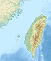
Skeda:Taiwan relief location map.jpg

Page contents not supported in other languages.
Nga Wikipedia, enciklopedia e lirë

Dokument origjinal((përmasa 1.016 × 1.222 px, madhësia skedës: 101 KB, lloji MIME: image/jpeg))

Kjo skedë është prej Wikimedia Commons dhe mund të përdoret nga projekte të tjera. Përshkrimi në këtë skedë në këtë faqe nuk është treguar më poshtë. Shko tek faqja përshkruese në Commons Shko tek faqja përshkruese në Commons

Warning sign This file requires updating because: The earlier forms of this map did not extend a dotted-line around Dongyin, Lienchiang (Tungyin). The northern edge of this map ought to be moved up a little bit (in latitude) so that a dotted line encompassing Dongyin (Tungyin) can be clearly drawn and so that we can see a few of the islands north of Lienchiang County in Haidao Township, PRC. Example of a better map from The Economist: [1]. In doing so, you could add a timestamp to the file.
Please notify the uploader with {{subst:update-note|1=File:Taiwan relief location map.jpg|2=The earlier forms of this map did not extend a dotted-line around Dongyin, Lienchiang (Tungyin). The northern edge of this map ought to be moved up a little bit (in latitude) so that a dotted line encompassing Dongyin (Tungyin) can be clearly drawn and so that we can see a few of the islands north of Lienchiang County in Haidao Township, PRC. Example of a better map from The Economist: [2].}} ~~~~

Përmbledhje

Përshkrimi
English: Relief location map of Taiwan.
  • Projection: Equirectangular projection, strechted by 110.0%.
  • Geographic limits of the map:
  • N: 26.4° N
  • S: 21.7° N
  • W: 118.0° E
  • E: 122.3° E
  • GMT projection: -JX17.204266666666665cd/20.68512992248063cd
  • GMT region: -R118.0/21.7/122.3/26.4r
  • GMT region for grdcut: -R118.0/21.7/122.3/26.4r
  • Relief: SRTM30plus.
  • Made with Natural Earth. Free vector and raster map data @ naturalearthdata.com.
Data
Burimi Punë e juaja
Autori Uwe Dedering

Licencim

Unë, krijuesi i kësaj pune, e publikoj këtu në bazë të licensës në vijim:
w:sq:Creative Commons
atribuim share alike
Kjo skedë është dhënë për përdorim sipas licensës Creative Commons Attribution-Share Alike 3.0 Unported, 2.5 Generic, 2.0 Generic dhe 1.0 Generic.
Je i lirë të:
  • ta shpërndani – ta kopjoni, rishpërndani dhe përcillni punën
  • t’i bëni “remix” – të përshtatni punën
Sipas kushteve të mëposhtme:
  • atribuim – Duhet t’i jepni meritat e duhura, të siguroni një lidhje për tek licenca dhe të tregoni nëse janë bërë ndryshime. Këtë mund ta bëni në ndonjë mënyrë të arsyeshme, por jo në ndonjë mënyrë që sugjeron se licencuesi ju del zot juve apo përdorimit tuaj.
  • share alike – Nëse bëni një “remix”, e shndërroni, ose ndërtoni duke u bazuar te materiali, duhet t’i shpërndani kontributet tuaja sipas të njëjtës licencë ose një të tille të përputhshme me origjinalen.
GNU head Ju jepet leje për ta kopjuar, shpërndarë dhe/ose ndryshuar këtë dokument sipas kushteve të Licencës GNU për Dokumentim të Lirë, versioni 1.2 ose çfarëdo versioni të mëpasshëm të botuar nga Free Software Foundation; pa Seksione të Pandryshueshme, pa Tekste Kapakësh të Përparmë, dhe pa Tekste Kapakësh të Pasmë. Një kopje e kësaj licence është përfshirë në seksionin e titulluar GNU Free Documentation License.
Mundeni të përzgjidhni licencën që doni.

Captions

Add a one-line explanation of what this file represents

Items portrayed in this file

përshkruan

28 dhjetor 2010

image/jpeg

Historiku skedës

Shtypni mbi një datë/kohë për ta parë skedën siç ishte atëherë.

Data/KohaMiniaturëPërmasatPërdoruesiKoment
e tanishme19 shtator 2019 16:01Miniaturë për versionin duke filluar nga 19 shtator 2019 16:011.016 × 1.222 (101 KB)Geographyinitiativetemporary fix: extending the boundary out around Dongyin Township (as in China Fujian2 location map.svg and as in File:Nationalist China - administrative divisons. LOC 2007633622.jpg)
3 gusht 2019 19:09Miniaturë për versionin duke filluar nga 3 gusht 2019 19:091.016 × 1.222 (537 KB)NordNordWestborder corrections
3 gusht 2019 03:51Miniaturë për versionin duke filluar nga 3 gusht 2019 03:511.016 × 1.222 (96 KB)GeographyinitiativeProposed removal of three dashes (markers of the approximate PRC/ROC maritime boundary) which seemed to put Dadan Island, Erdan Island and Binlang Islet (檳榔嶼) outside the territory of Kinmen County, Taiwan/ROC. This is not the optimal form of the map, but is merely a quick removal of incorrect information. In the optimal situation, the line needs to be redrawn in the correct location, but I don't have the technical skill to produce such a map. (Basis: [http://ws.mac.gov.tw/001/Upload/OldFile/...
3 gusht 2019 02:30Miniaturë për versionin duke filluar nga 3 gusht 2019 02:301.016 × 1.222 (96 KB)GeographyinitiativeProposed removal of two dashes (markers of the approximate PRC/ROC maritime boundary) which seemed to put {{w|Dadan Island}} and {{w|Erdan Island}} outside the territory of {{w|Kinmen County}}, Taiwan/ROC.
28 dhjetor 2010 19:22Miniaturë për versionin duke filluar nga 28 dhjetor 2010 19:221.016 × 1.222 (452 KB)Uwe Dedering{{Information |Description={{en|1=Relief location map of Taiwan. * Projection: Equirectangular projection, strechted by 110.0%. * Geographic limits of the map: :* N: 26.4° N :* S: 21.7° N :* W: 118.0° E :* E: 122.3° E * GMT projection: -JX17.204266666

Këto faqe lidhen tek kjo skedë:

Përdorimi global i skedës

Kjo skedë përdoret nga Wiki të tjera në vijim:

Shikoni më shumë përdorim global të kësaj skede.

Metadata