
Skeda:The Ancient Roads of Italy and Sicily nopng.svg

Dokument origjinal (skedë SVG, fillimisht 1.201 × 1.340 pixel, madhësia e skedës: 245 KB)
| Kjo skedë është prej Wikimedia Commons dhe mund të përdoret nga projekte të tjera. Përshkrimi në këtë skedë në këtë faqe nuk është treguar më poshtë. | Shko tek faqja përshkruese në Commons |
Përmbledhje
| Përshkrimi |
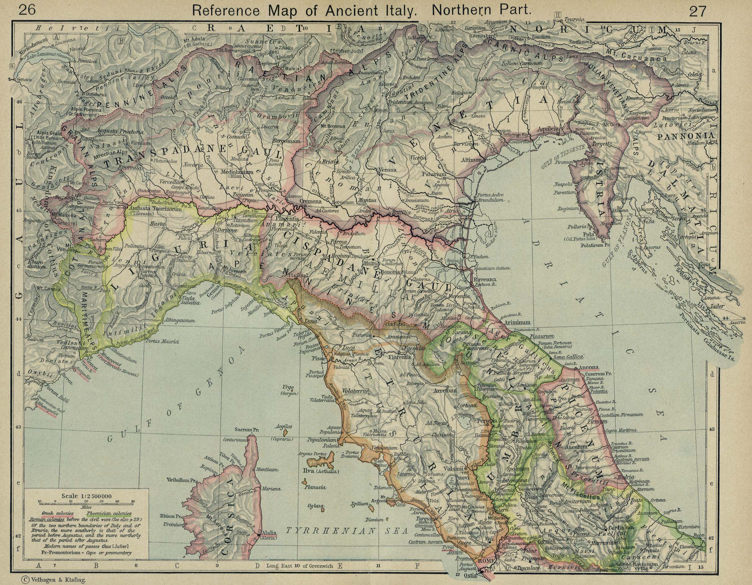
English: The major roads of Italy (going from Rome) are as follows, going clockwise from the left:
Corrections and additions are welcome! |
||
| Data | |||
| Burimi | Punë e juaja | ||
| Autori | Agamemnus | ||
| Versione tjera |
|

Licencim
| Unë,krijuesi i kësaj pune, e lëshoj këtë punë në public domain. Kjo aplikohet në të gjithë botën. Në disa vende kjo mund të mos jetë e mundur ligjërisht; nëse është kështu: Unë i garantoj çdokujt të drejtën për ta përdorur këtë punë për çdo qëllim, pa asnjë kusht, përveç rasteve kur këto kushte janë të kërkuara nga ligji. |
Historiku skedës
Shtypni mbi një datë/kohë për ta parë skedën siç ishte atëherë.
| Data/Koha | Miniaturë | Përmasat | Përdoruesi | Koment | |
|---|---|---|---|---|---|
| e tanishme | 24 prill 2020 03:24 | | 1.201 × 1.340 (245 KB) | Ciaurlec | Changed alpha channel values to make it lighter |
| 20 shkurt 2010 10:07 |  | 1.201 × 1.340 (245 KB) | Agamemnus | Bringing back a road that went missing. | |
| 13 shkurt 2010 06:25 |  | 1.201 × 1.340 (239 KB) | Agamemnus | One more color change. | |
| 13 shkurt 2010 06:19 |  | 1.201 × 1.340 (239 KB) | Agamemnus | Color change.. | |
| 13 shkurt 2010 06:14 |  | 1.201 × 1.340 (239 KB) | Agamemnus | Minor road edit. | |
| 13 shkurt 2010 06:04 |  | 1.201 × 1.340 (238 KB) | Agamemnus | Added a little compass showing north. Added a scale strip next to the compass. Changed Via Tiburtina color to dark purple. | |
| 9 shkurt 2010 20:05 |  | 1.201 × 1.340 (230 KB) | Agamemnus | Moved the italy/sicily svg down so the roads could be seen again... | |
| 9 shkurt 2010 10:18 |  | 1.201 × 1.340 (230 KB) | Agamemnus | Teh Sicily portion of the SVG is now more detailed. | |
| 9 shkurt 2010 07:16 |  | 1.201 × 1.340 (220 KB) | Agamemnus | {{Information |Description={{en|1=The major roads of Italy (going from Rome) are as follows, going clockwise from the left: Green: Via Aurelia -> Via Aumelia Scaura -> Via Julia Augusta Bright green: Via Clodia Yellow: Via Cassia Blue: Via Flaminia Grey: |
Lidhje skedash
Këto faqe lidhen tek kjo skedë:
Përdorimi global i skedës
Kjo skedë përdoret nga Wiki të tjera në vijim:
- Përdorimi në ca.wikipedia.org
- Përdorimi në en.wikipedia.org
- Përdorimi në fr.wikipedia.org
- Përdorimi në la.wikipedia.org
- Përdorimi në uk.wikipedia.org
- Përdorimi në zh.wikipedia.org