
Skeda:Whole world - land and oceans 12000.jpg

Madhësia e këtij shikimi: 800 × 400 pixel. Rezolucione të tjera: 320 × 160 pixel | 640 × 320 pixel | 1.024 × 512 pixel | 1.280 × 640 pixel | 2.560 × 1.280 pixel | 24.000 × 12.000 pixel.
Dokument origjinal ((përmasa 24.000 × 12.000 px, madhësia skedës: 19,11 MB, lloji MIME: image/jpeg))
| Kjo skedë është prej Wikimedia Commons dhe mund të përdoret nga projekte të tjera. Përshkrimi në këtë skedë në këtë faqe nuk është treguar më poshtë. | Shko tek faqja përshkruese në Commons |
Përmbledhje
| Warning | The original file is very high-resolution. It might not load properly or could cause your browser to freeze when opened at full size. |
|---|
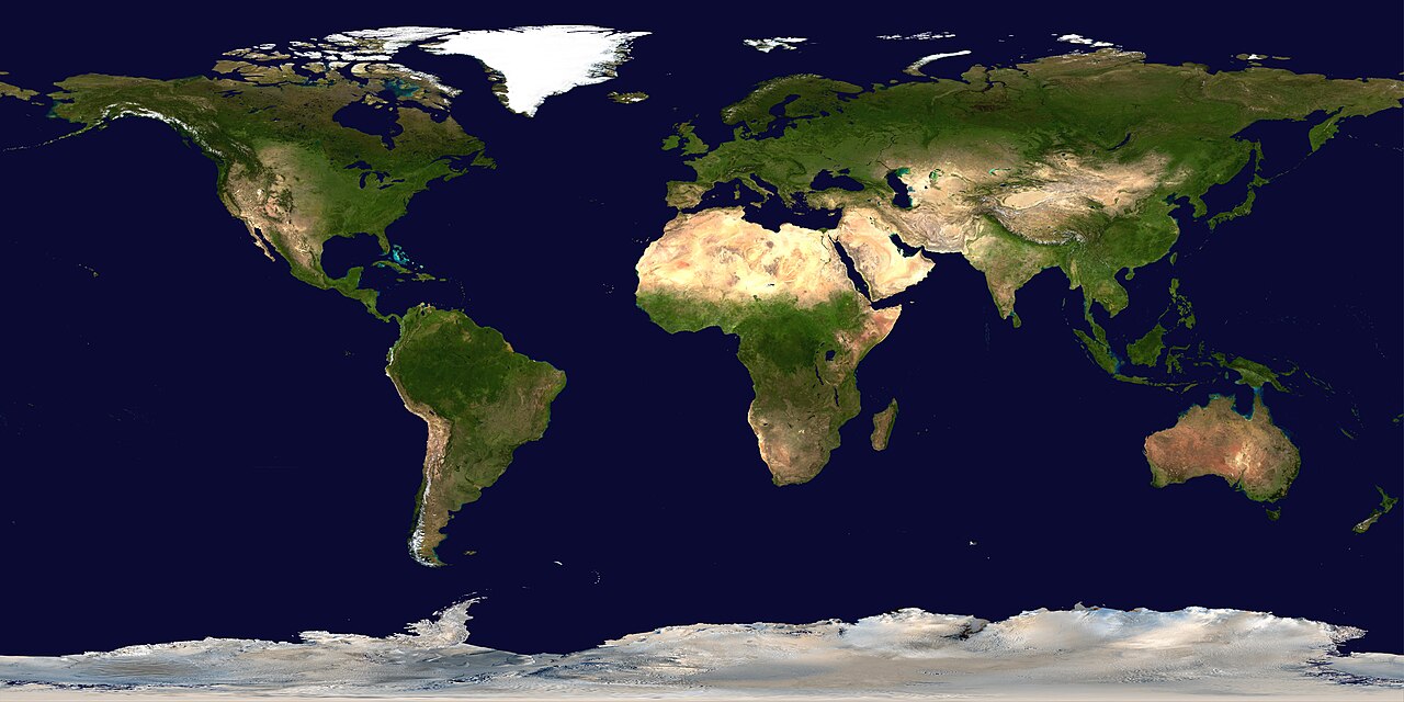
| Përshkrimi |
Deutsch: Satellitenbild der Erdoberoberfläche.
English: Satellite composition of the whole Earth's surface.
العربية: صور ساتليَّة مُجمَّعة لتُظهر سطح الأرض كاملًا. |
| Data | image released 11. Feb. 2002 |
| Burimi |
NASA - Visible Earth, images combined and scaled down by HighInBC (20 megabyte upload limit) |
| Autori | NASA/Goddard Space Flight Center |
| Leja (Ripërdor këtë skedë) |
Copyright information from http://visibleearth.nasa.gov/useterms.php - With the exception of images produced by the SeaWiFS, QuickBird, and IKONOS instruments all images on the Visible Earth are governed by NASA's Terms of Use below. [...] For all non-private uses, NASA's Terms Of Use are as follows: 1. The imagery is free of licensing fees 2. NASA requires that they be provided a credit as the owners of the imagery [...] |
| Versione tjera |
|


|

Licencim
| This file is in the public domain in the United States because it was solely created by NASA. NASA copyright policy states that "NASA material is not protected by copyright unless noted". (See Template:PD-USGov, NASA copyright policy page or JPL Image Use Policy.) | ||
 |
Warnings:
|
Historiku skedës
Shtypni mbi një datë/kohë për ta parë skedën siç ishte atëherë.
| Data/Koha | Miniaturë | Përmasat | Përdoruesi | Koment | |
|---|---|---|---|---|---|
| e tanishme | 14 gusht 2006 21:58 | | 24.000 × 12.000 (19,11 MB) | HInBC | {{Information| |Description = Satellite composition of the whole Earth's surface. |Source = NASA - Visible Earth, images combined and scaled down by HighInBC (20 megabyte upload limit) * [http://visibleearth.nasa.gov/view_rec.php?vev1id= |
Lidhje skedash
Këto faqe lidhen tek kjo skedë:
Përdorimi global i skedës
Kjo skedë përdoret nga Wiki të tjera në vijim:
- Përdorimi në als.wikipedia.org
- Përdorimi në arc.wikipedia.org
- Përdorimi në ar.wikipedia.org
- مستخدم:ديفيد/صور ساهمت في جعلها مختارة
- ويكيبيديا:ترشيحات الصور المختارة/صورة لقارات العالم بالقمر الصناعي
- ويكيبيديا:صورة اليوم المختارة/يوليو 2015
- قالب:صورة اليوم المختارة/2015-07-26
- ويكيبيديا:صورة اليوم المختارة/أكتوبر 2016
- قالب:صورة اليوم المختارة/2016-10-03
- ويكيبيديا:صورة اليوم المختارة/يوليو 2018
- قالب:صورة اليوم المختارة/2018-07-22
- ويكيبيديا:صورة اليوم المختارة/سبتمبر 2022
- قالب:صورة اليوم المختارة/2022-09-10
- ويكيبيديا:ترشيحات الصور المختارة/سحب/الرخام الأزرق
- Përdorimi në arz.wikipedia.org
- Përdorimi në ast.wikipedia.org
- Përdorimi në bg.wikipedia.org
- Përdorimi në bi.wikipedia.org
- Përdorimi në bpy.wikipedia.org
- Përdorimi në br.wikipedia.org
- Përdorimi në ca.wikipedia.org
- Përdorimi në ca.wikibooks.org
- Përdorimi në ceb.wikipedia.org
- Përdorimi në co.wikipedia.org
- Përdorimi në cs.wikipedia.org
- Përdorimi në de.wikipedia.org
- Përdorimi në de.wikinews.org
- Përdorimi në de.wiktionary.org
Shikoni më shumë përdorim global të kësaj skede.