
Skeda:COVID-19 Outbreak Cases in New Zealand (DHB Totals).svg

Size of this PNG preview of this SVG file: 460 × 599 pixel. Rezolucione të tjera: 184 × 240 pixel | 369 × 480 pixel | 590 × 768 pixel | 787 × 1.024 pixel | 1.573 × 2.048 pixel | 650 × 846 pixel.
Dokument origjinal (skedë SVG, fillimisht 650 × 846 pixel, madhësia e skedës: 138 KB)
| Kjo skedë është prej Wikimedia Commons dhe mund të përdoret nga projekte të tjera. Përshkrimi në këtë skedë në këtë faqe nuk është treguar më poshtë. | Shko tek faqja përshkruese në Commons |
.svg)
Përmbledhje

|
This file may be updated to reflect new information. If you wish to use a specific version of the file without new updates being mirrored, please upload the required version as a separate file. |
| Përshkrimi |
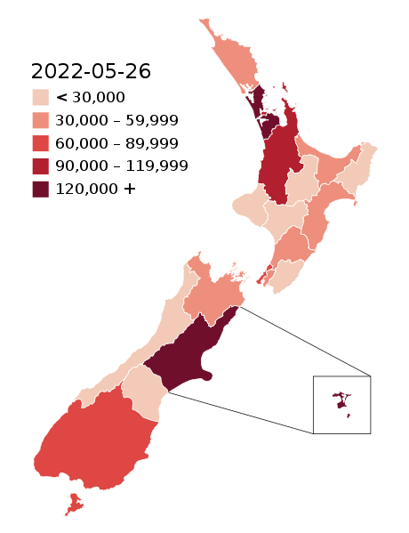
English: Map of the COVID-19 outbreak in New Zealand with case totals by District Health Board (DHB) as of 28 February 2022. Be aware that since this is a rapidly evolving situation, new cases may not be immediately represented visually. Refer to the primary article 2019–20 coronavirus outbreak by country and territory or the World Health Organization's situation reports for most recent reported case information.
The data ranges for each colour may be updated periodically to reflect changing data. Numerical ranges for each colour are calculated to give equally sized ranges. N.B: Stewart Island and Chatham Island are associated with the Southern DHB and Canterbury DHB (respectively). The colours for those islands represent the overall DHB case numbers, not the number of cases present on those islands specifically. |
| Data | |
| Burimi |
|
| Autori |
Base map: Base map: Stats NZ, edits by Air55 Colourisation: multiple authors |
.svg)
Licencim
This file is licensed under the Creative Commons Attribution-Share Alike 4.0 International license.
- Je i lirë të:
- ta shpërndani – ta kopjoni, rishpërndani dhe përcillni punën
- t’i bëni “remix” – të përshtatni punën
- Sipas kushteve të mëposhtme:
- atribuim – Duhet t’i jepni meritat e duhura, të siguroni një lidhje për tek licenca dhe të tregoni nëse janë bërë ndryshime. Këtë mund ta bëni në ndonjë mënyrë të arsyeshme, por jo në ndonjë mënyrë që sugjeron se licencuesi ju del zot juve apo përdorimit tuaj.
- share alike – Nëse bëni një “remix”, e shndërroni, ose ndërtoni duke u bazuar te materiali, duhet t’i shpërndani kontributet tuaja sipas të njëjtës licencë ose një të tille të përputhshme me origjinalen.
Historiku skedës
Shtypni mbi një datë/kohë për ta parë skedën siç ishte atëherë.
.svg&dir=prev)
.svg&offset=20220129003640)
.svg&offset=&limit=20)
.svg&offset=&limit=50)
.svg&offset=&limit=100)
.svg&offset=&limit=250)
.svg&offset=&limit=500)
| Data/Koha | Miniaturë | Përmasat | Përdoruesi | Koment | |
|---|---|---|---|---|---|
| e tanishme | 26 maj 2022 05:55 | | 650 × 846 (138 KB) | Air55 | Updated totals as of 26 May 2022 |
| 3 prill 2022 04:25 |  | 650 × 846 (138 KB) | Air55 | updated totals as of 2 April 2022 | |
| 17 mars 2022 09:47 |  | 650 × 846 (138 KB) | Air55 | updated totals | |
| 8 mars 2022 02:48 |  | 650 × 846 (138 KB) | Air55 | case totals + scale update | |
| 6 mars 2022 04:16 |  | 650 × 846 (138 KB) | Air55 | updated case totals | |
| 2 mars 2022 03:42 |  | 650 × 846 (138 KB) | Air55 | updated ranges | |
| 2 mars 2022 03:09 |  | 650 × 846 (138 KB) | Air55 | 02 March 2022 totals | |
| 1 mars 2022 06:43 |  | 650 × 846 (138 KB) | Air55 | Redid map. Legend now features in map for ease of updating across all pages, colour bins updated | |
| 1 mars 2022 05:06 |  | 650 × 846 (135 KB) | Air55 | updated as of 28 Feb. will be looking at making a new version of this map in light of the rapidly rising cases | |
| 29 janar 2022 02:36 |  | 650 × 846 (135 KB) | Air55 | Updated case totals for 28 January 2022. Colours changed for BOP, Lakes, and Canterbury DHBs. |
Lidhje skedash
Këto faqe lidhen tek kjo skedë:
Përdorimi global i skedës
Kjo skedë përdoret nga Wiki të tjera në vijim:
- Përdorimi në de.wikipedia.org
- Përdorimi në en.wikipedia.org
- Përdorimi në es.wikipedia.org
- Përdorimi në fa.wikipedia.org
- Përdorimi në fr.wikipedia.org
- Përdorimi në he.wikipedia.org
- Përdorimi në id.wikipedia.org
- Përdorimi në ko.wikipedia.org
- Përdorimi në ms.wikipedia.org
- Përdorimi në nl.wikipedia.org
- Përdorimi në ru.wikipedia.org
- Përdorimi në simple.wikipedia.org
- Përdorimi në th.wikipedia.org
- Përdorimi në uk.wikipedia.org
- Përdorimi në uz.wikipedia.org
- Përdorimi në vi.wikipedia.org
- Përdorimi në zh-yue.wikipedia.org
- Përdorimi në zh.wikipedia.org
.svg)