Skeda:Map Wales Location UK.jpg

Page contents not supported in other languages.
Nga Wikipedia, enciklopedia e lirë

Map_Wales_Location_UK.jpg((përmasa 480 × 430 px, madhësia skedës: 26 KB, lloji MIME: image/jpeg))

Kjo skedë është prej Wikimedia Commons dhe mund të përdoret nga projekte të tjera. Përshkrimi në këtë skedë në këtë faqe nuk është treguar më poshtë. Shko tek faqja përshkruese në Commons Shko tek faqja përshkruese në Commons

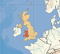
Përshkrimi Location of Wales in UK, on terrain map showing surface and underwater contour areas.
Data
Burimi Derived from Wikimedia Commons image of original work forming part of the "Europe location" map series created by David Liuzzo: derived from Image:Europe_location_WAL.png.
Autori uploaded by User:Wikid77 (excerpt from User:David_Liuzzo)
Leja
(Ripërdor këtë skedë)
© Krijuesi i kësaj skede lejon këdo ta përdorë për çdo qëllim, me kusht që krijuesi është i atribuar si duhet. Rishpërndarja, puna derivative, përdorimi komercial, dhe të gjitha përdorimet janë të lejuara.
Atribuim:

You are kindly requested to contact David Liuzzo before using this material to create a new locator map for a country or region to be used on a wikimedia project. Also, please ensure that these stay in line with the original design scheme and its intention to maintain the consistent look of David Liuzzo's "Europe location" map series. For map requests and questions regarding the design scheme, please contact David Liuzzo.
Versione tjera

Captions

Add a one-line explanation of what this file represents

Items portrayed in this file

përshkruan

5 prill 2008

Historiku skedës

Shtypni mbi një datë/kohë për ta parë skedën siç ishte atëherë.

Data/KohaMiniaturëPërmasatPërdoruesiKoment
e tanishme5 prill 2008 20:30Miniaturë për versionin duke filluar nga 5 prill 2008 20:30480 × 430 (26 KB)Wikid77{{Information |Description=Wales |Source=self-made }}{{PD-self}}

S’ka faqe që përdorin këtë kartelë.

Përdorimi global i skedës

Kjo skedë përdoret nga Wiki të tjera në vijim:

Metadata