
Skeda:Map of downtown Rome during the Roman Empire large.png

Madhësia e këtij shikimi: 800 × 566 pixel. Rezolucione të tjera: 320 × 226 pixel | 640 × 452 pixel | 1.024 × 724 pixel | 1.099 × 777 pixel.
Dokument origjinal ((përmasa 1.099 × 777 px, madhësia skedës: 74 KB, lloji MIME: image/png))
| Kjo skedë është prej Wikimedia Commons dhe mund të përdoret nga projekte të tjera. Përshkrimi në këtë skedë në këtë faqe nuk është treguar më poshtë. | Shko tek faqja përshkruese në Commons |
| This is a retouched picture, which means that it has been digitally altered from its original version. Modifications: rasterized. The original can be viewed here: Map of downtown Rome during the Roman Empire large.jpg: File:Map of downtown Rome during the Roman Empire large.jpg. Modifications made by Helix84.
|
Përmbledhje
| Përshkrimi |
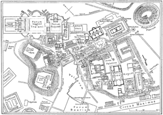
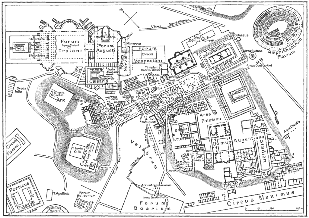
Deutsch: Karte der antiken Innenstadt von Rom |
| Data | |
| Burimi | from the Nordisk familjebok (1916), band 23, artikeln "Rom" [1], upload to Swedish wikipedia 23.10.2003 by Den fjättrade ankan |
| Autori | I panjohur |
| Versione tjera | Derivative works of this file: Forum Romanum Arcus Augusti.jpg |
Licencim
This image was first published in the 1st (1876–1899), 2nd (1904–1926) or 3rd (1923–1937) edition of Nordisk familjebok. The copyrights for that book have expired and this image is in the public domain, because images had no named authors and the book was published more than 70 years ago.
|
This image (or other media file) is in the public domain because its copyright has expired and its author is anonymous.
This applies to the European Union and those countries with a copyright term of 70 years after the work was made available to the public and the author never disclosed their identity. Important: Always mention where the image comes from, as far as possible, and make sure the author never claimed authorship. |
 | |
 |
Note: In Germany and possibly other countries, certain anonymous works published before July 1, 1995 are copyrighted until 70 years after the death of the author. See Übergangsrecht. Please use this template only if the author never claimed authorship or their authorship never became public in any other way. If the work is anonymous or pseudonymous (e.g., published only under a corporate or organization's name), use this template for images published more than 70 years ago.
For a work made available to the public in the United Kingdom, please use Template:PD-UK-unknown instead.
|
Regjistri origjinal i ngarkimeve
23 oktober 2003 kl.00.39 . . Den fjättrade ankan (Diskussion | Bidrag) . . 1099x777 (209 832 bytes)
Historiku skedës
Shtypni mbi një datë/kohë për ta parë skedën siç ishte atëherë.
| Data/Koha | Miniaturë | Përmasat | Përdoruesi | Koment | |
|---|---|---|---|---|---|
| e tanishme | 31 tetor 2006 04:05 | | 1.099 × 777 (74 KB) | Helix84 | Rasterized Image:Map_of_downtown_Rome_during_the_Roman_Empire_large.jpg. ~~~~ Original desc. follows: ---- *{{en|<br> **'''Description''': Map of antique downtown Rome, drawing. **'''Author''': [[:sv:Användare:Den fjättrade ankan|Den fjättrade an |
Lidhje skedash
S’ka faqe që përdorin këtë kartelë.
Përdorimi global i skedës
Kjo skedë përdoret nga Wiki të tjera në vijim:
- Përdorimi në bcl.wikipedia.org
- Përdorimi në be-tarask.wikipedia.org
- Përdorimi në be.wikipedia.org
- Përdorimi në bg.wikipedia.org
- Përdorimi në br.wikipedia.org
- Përdorimi në bs.wikipedia.org
- Përdorimi në ca.wikipedia.org
- Përdorimi në cs.wikipedia.org
- Përdorimi në de.wikipedia.org
- Përdorimi në el.wikipedia.org
- Përdorimi në en.wikipedia.org
- Përdorimi në eo.wikipedia.org
- Përdorimi në es.wikipedia.org
- Përdorimi në et.wikipedia.org
- Përdorimi në eu.wikipedia.org
- Përdorimi në fi.wikipedia.org
Shikoni më shumë përdorim global të kësaj skede.