
Skeda:Regions of Europe Map.png
Madhësia e këtij shikimi: 800 × 531 pixel. Rezolucione të tjera: 320 × 212 pixel | 640 × 425 pixel | 1.070 × 710 pixel.
Dokument origjinal ((përmasa 1.070 × 710 px, madhësia skedës: 319 KB, lloji MIME: image/png))
| Kjo skedë është prej Wikimedia Commons dhe mund të përdoret nga projekte të tjera. Përshkrimi në këtë skedë në këtë faqe nuk është treguar më poshtë. | Shko tek faqja përshkruese në Commons |
Përmbledhje
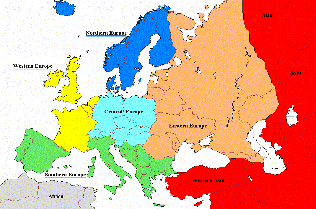
| Përshkrimi |
English: Regions of Europe with labels and corrected coloring |
| Data | |
| Burimi | File:Regions_of_Europe_Map.png |
| Autori | Koyos |
| Versione tjera |
|

Licencim
| Unë,krijuesi i kësaj pune, e lëshoj këtë punë në public domain. Kjo aplikohet në të gjithë botën. Në disa vende kjo mund të mos jetë e mundur ligjërisht; nëse është kështu: Unë i garantoj çdokujt të drejtën për ta përdorur këtë punë për çdo qëllim, pa asnjë kusht, përveç rasteve kur këto kushte janë të kërkuara nga ligji. |
Historiku skedës
Shtypni mbi një datë/kohë për ta parë skedën siç ishte atëherë.
| Data/Koha | Miniaturë | Përmasat | Përdoruesi | Koment | |
|---|---|---|---|---|---|
| e tanishme | 19 gusht 2022 12:06 | | 1.070 × 710 (319 KB) | Рагин1987 | Cyprus shaded |
| 28 nëntor 2011 08:01 |  | 1.070 × 710 (171 KB) | DerFreischutz | Changed color according to the boundary. Everything above the border is Eastern Europe. | |
| 3 shkurt 2009 11:48 |  | 1.070 × 710 (150 KB) | Koyos | reverting geographically inaccurate color coding | |
| 18 korrik 2008 12:40 |  | 1.070 × 710 (57 KB) | Aegean Boy~commonswiki | {{Information |Description= |Source= |Date= |Author= |Permission= |other_versions= }} | |
| 23 gusht 2006 11:29 |  | 1.070 × 710 (150 KB) | Aongus | {{Information |Description=Regions of Europe |Permission= {{PD}} }} |
Lidhje skedash
Këto faqe lidhen tek kjo skedë:
Përdorimi global i skedës
Kjo skedë përdoret nga Wiki të tjera në vijim:
- Përdorimi në af.wiktionary.org
- Përdorimi në cdo.wikipedia.org
- Përdorimi në de.wiktionary.org
- Përdorimi në es.wikipedia.org
- Përdorimi në nl.wiktionary.org
- Përdorimi në sh.wikipedia.org
- Përdorimi në sl.wiktionary.org
- Përdorimi në sr.wikipedia.org