
Skeda:South asia.jpg
Nuk ka përmasa më të madhaja.
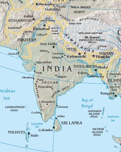
South_asia.jpg ((përmasa 425 × 533 px, madhësia skedës: 52 KB, lloji MIME: image/jpeg))
| Kjo skedë është prej Wikimedia Commons dhe mund të përdoret nga projekte të tjera. Përshkrimi në këtë skedë në këtë faqe nuk është treguar më poshtë. | Shko tek faqja përshkruese në Commons |
Përmbledhje
| Përshkrimi |
Import from File:South asia.jpg 26 July 2008 English: The image is cropped from en:Image:Sino-Indian Geography.png, created and published by the en:Central Intelligence Agency of the en:United States of America in en:2004.
NoteThis map represents the en:line of control in en:Kashmir as the international border between the en:Republic of India and en:Islamic Republic of Pakistan, a position considered unacceptable to either party. |
| Burimi | CIA World Factbook |
| Autori | CIA |

|
Kjo map fotografi duhet duhen te behen edhe i here si nje SVG.
|


Licencim
This image is in the public domain because it contains materials that originally came from the United States Central Intelligence Agency's World Factbook.
|
 |
Regjistri origjinal i ngarkimeve
The original description page was here. All following user names refer to en.wikipedia.
- 2003-10-28 08:22 Mkweise 421×541×8 (88052 bytes) cropped from PD image
Historiku skedës
Shtypni mbi një datë/kohë për ta parë skedën siç ishte atëherë.
| Data/Koha | Miniaturë | Përmasat | Përdoruesi | Koment | |
|---|---|---|---|---|---|
| e tanishme | 6 gusht 2008 18:59 | | 425 × 533 (52 KB) | Deepak~commonswiki | |
| 27 korrik 2008 02:48 |  | 421 × 541 (86 KB) | File Upload Bot (Magnus Manske) | {{BotMoveToCommons|en.wikipedia}} {{Information |Description={{en|<small>The image is cropped from en::Image:Sino-Indian Geography.png, created and published by the en:Central Intelligence Agency of the en:United States of America in [[:en |
Lidhje skedash
S’ka faqe që përdorin këtë kartelë.
Përdorimi global i skedës
Kjo skedë përdoret nga Wiki të tjera në vijim:
- Përdorimi në ace.wikipedia.org
- Përdorimi në ar.wikipedia.org
- Përdorimi në ast.wikipedia.org
- Përdorimi në bg.wikipedia.org
- Përdorimi në bs.wikipedia.org
- Përdorimi në cy.wikipedia.org
- Përdorimi në en.wikipedia.org
- Përdorimi në es.wikipedia.org
- Përdorimi në id.wikipedia.org
- Përdorimi në incubator.wikimedia.org
- Përdorimi në jv.wikipedia.org
- Përdorimi në kn.wikipedia.org
- Përdorimi në la.wikipedia.org
- Përdorimi në ml.wikipedia.org
- Përdorimi në ms.wikipedia.org
- Përdorimi në pam.wikipedia.org
- Përdorimi në pl.wiktionary.org
- Përdorimi në pnb.wikipedia.org
- Përdorimi në rmy.wikipedia.org
- Përdorimi në ru.wikipedia.org
- Përdorimi në sh.wikipedia.org
- Përdorimi në simple.wikipedia.org
- Përdorimi në sr.wikipedia.org
- Përdorimi në sv.wikipedia.org
- Përdorimi në ta.wikipedia.org
- Përdorimi në te.wikipedia.org
- Përdorimi në tl.wikipedia.org
- Përdorimi në tr.wikipedia.org
- Përdorimi në tr.wiktionary.org
- Përdorimi në war.wikipedia.org
- Përdorimi në www.wikidata.org
- Përdorimi në zh.wikipedia.org
Shikoni më shumë përdorim global të kësaj skede.