Skeda:Stielers Handatlas 1891 50.jpg

Page contents not supported in other languages.
Nga Wikipedia, enciklopedia e lirë

Dokument origjinal((përmasa 5.000 × 4.250 px, madhësia skedës: 6,61 MB, lloji MIME: image/jpeg))

Kjo skedë është prej Wikimedia Commons dhe mund të përdoret nga projekte të tjera. Përshkrimi në këtë skedë në këtë faqe nuk është treguar më poshtë. Shko tek faqja përshkruese në Commons Shko tek faqja përshkruese në Commons

Warning The original file is very high-resolution. It might not load properly or could cause your browser to freeze when opened at full size.
Template:Stielers Handatlas 1891
Autori
Adolf Stieler  (1775–1836)  wikidata:Q62914 s:en:Author:Adolf Stieler
 
Adolf Stieler
Emrat alternative
Adolph Stieler; Stieler
Përshkrimi cartographer dhe shtypshkronjë
Data e lindjes/vdekjes 26 shkurt 1775 Edit this at Wikidata 13 mars 1836 Edit this at Wikidata
Vendi e lindjes/vdekjes Gotha ebenda
Vendndodhja e punës
Authority file
author QS:P50,Q62914
August Heinrich Petermann  (1822–1878)  wikidata:Q63230 s:en:Author:August Heinrich Petermann
 
August Heinrich Petermann
Emrat alternative
August Peterman; August Heinrich Petermann; Petermann; August Heinrich PETERMANN
Përshkrimi German cartographer, scientific illustrator dhe gjeograf
Data e lindjes/vdekjes 18 prill 1822 Edit this at Wikidata 25 shtator 1878 Edit this at Wikidata
Vendi e lindjes/vdekjes Bleicherode Gotha
Authority file
author QS:P50,Q63230
Carl Vogel  (1828–1897)  wikidata:Q6226563 s:de:Carl Vogel
 
Carl Vogel
Përshkrimi German cartographer, topographer dhe surveying engineer
deutscher Kartograph
Data e lindjes/vdekjes 4 maj 1828 Edit this at Wikidata 16 korrik 1897 Edit this at Wikidata
Vendi e lindjes/vdekjes Bad Hersfeld Gotha
Vendndodhja e punës
Authority file
author QS:P50,Q6226563
Hermann Berghaus  (1828–1890)  wikidata:Q74679
 
Hermann Berghaus
Emrat alternative
Berghaus
Përshkrimi German cartographer dhe gjeograf
Data e lindjes/vdekjes 16 nëntor 1828 Edit this at Wikidata 3 dhjetor 1890 Edit this at Wikidata
Vendi e lindjes/vdekjes Herford Gotha
Vendndodhja e punës
Authority file
author QS:P50,Q74679
Hermann Habenicht  (1844–1917)  wikidata:Q13377354
 
Përshkrimi gjeograf
Data e lindjes/vdekjes 3 mars 1844 Edit this at Wikidata 30 mars 1917 / 1917 Edit this at Wikidata
Vendi e lindjes/vdekjes Gotha Gotha
Authority file
author QS:P50,Q13377354
  • Publisher: Gotha: Justus Perthes
Përshkrimi
Deutsch: Balkan-Halbinsel. Übersicht
English: Balkan peninsula. Overview
Data e publikimit 1891
publication_date QS:P577,+1891-00-00T00:00:00Z/9
Burimi Adolf Stielers Handatlas
Leja
(Ripërdor këtë skedë)
Public domain

This work is in the public domain in its country of origin and other countries and areas where the copyright term is the author's life plus 100 years or fewer.


This work is in the public domain in the United States because it was published (or registered with the U.S. Copyright Office) before January 1, 1929.

Captions

Add a one-line explanation of what this file represents
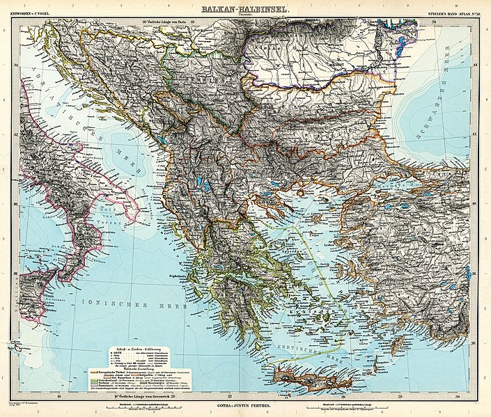
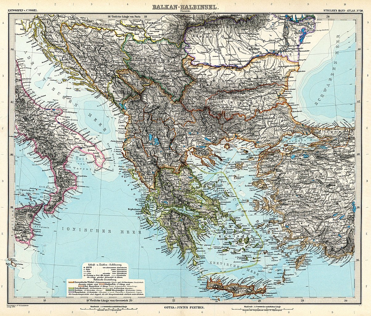
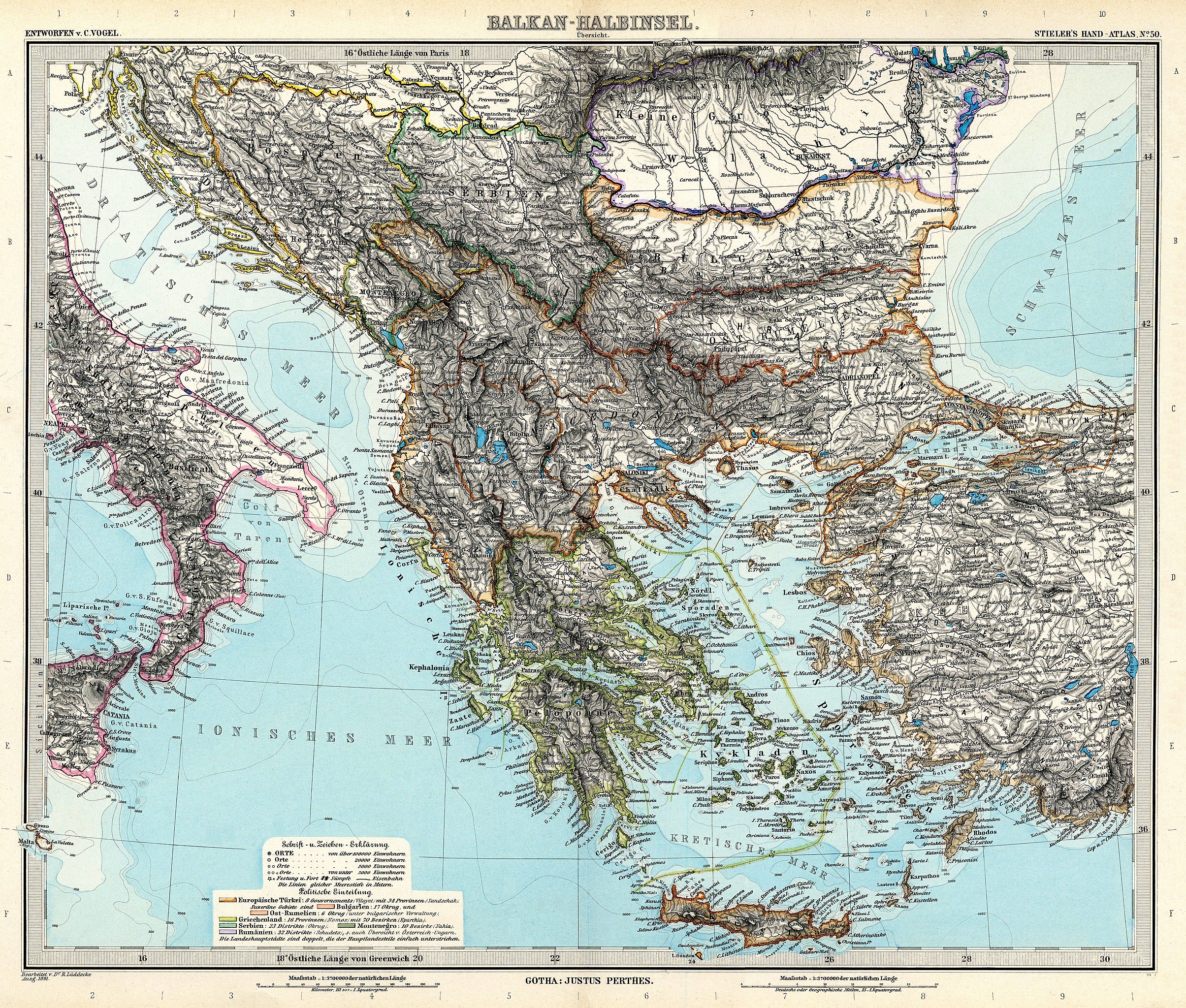
Items portrayed in this file

përshkruan

image/jpeg

Historiku skedës

Shtypni mbi një datë/kohë për ta parë skedën siç ishte atëherë.

Data/KohaMiniaturëPërmasatPërdoruesiKoment
e tanishme13 mars 2010 09:51Miniaturë për versionin duke filluar nga 13 mars 2010 09:515.000 × 4.250 (6,61 MB)Kolossosbetter quality
21 nëntor 2006 19:40Miniaturë për versionin duke filluar nga 21 nëntor 2006 19:403.749 × 3.187 (1,22 MB)Poccil{{Stielers Handatlas 1891|49|51|Balkan-Halbinsel. Übersicht|Balkan peninsula. Overview}} Category:Old maps of the Balkans

Këto faqe lidhen tek kjo skedë:

Përdorimi global i skedës

Kjo skedë përdoret nga Wiki të tjera në vijim:

Shikoni më shumë përdorim global të kësaj skede.

Metadata