
Skeda:Five Points intersection, Loveland, Ohio.jpg

Madhësia e këtij shikimi: 799 × 106 pixel. Rezolucione të tjera: 320 × 42 pixel | 640 × 85 pixel | 4.821 × 640 pixel.
Dokument origjinal ((përmasa 4.821 × 640 px, madhësia skedës: 790 KB, lloji MIME: image/jpeg))
| Kjo skedë është prej Wikimedia Commons dhe mund të përdoret nga projekte të tjera. Përshkrimi në këtë skedë në këtë faqe nuk është treguar më poshtë. | Shko tek faqja përshkruese në Commons |
Përmbledhje
| Përshkrimi |
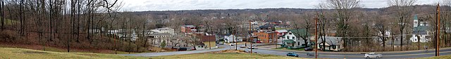
English: A panorama overlooking Historic Downtown Loveland, Ohio, United States, taken near the Bible Believer's Baptist Church.
In the center is the Five Points intersection of Broadway Street (lower and upper left), East Broadway Street (lower right), North Second Street (center right), and South Second Street (center left). The intersection has since been reconfigured so that South Second Street empties directly into Broadway Street and the remaining four ways meet at a traffic light. In the distance is West Loveland Avenue, the main street of Historic Downtown Loveland, seen in Historic Downtown Loveland, Ohio.jpg. Several buildings in the center have been razed to make way for a four-story apartment complex. |
| Data | Compiled 2008-12-11 |
| Burimi | LOVELAND 22_copy |
| Autori | R.P. Piper |
| Camera location | | View this and other nearby images on: OpenStreetMap |
|---|
Licencim
Kjo skedë është dhënë për përdorim sipas licensës Creative Commons Attribution 2.0 Generic.
- Je i lirë të:
- ta shpërndani – ta kopjoni, rishpërndani dhe përcillni punën
- t’i bëni “remix” – të përshtatni punën
- Sipas kushteve të mëposhtme:
- atribuim – Duhet t’i jepni meritat e duhura, të siguroni një lidhje për tek licenca dhe të tregoni nëse janë bërë ndryshime. Këtë mund ta bëni në ndonjë mënyrë të arsyeshme, por jo në ndonjë mënyrë që sugjeron se licencuesi ju del zot juve apo përdorimit tuaj.
| This image was originally posted to Flickr by R.P. Piper at https://flickr.com/photos/28817565@N03/3100710557. It was reviewed on 24 janar 2009 by FlickreviewR and was confirmed to be licensed under the terms of the cc-by-2.0. |
| Annotations | This image is annotated: View the annotations at Commons |
Historiku skedës
Shtypni mbi një datë/kohë për ta parë skedën siç ishte atëherë.
| Data/Koha | Miniaturë | Përmasat | Përdoruesi | Koment | |
|---|---|---|---|---|---|
| e tanishme | 23 janar 2009 23:10 | 4.821 × 640 (790 KB) | Mxn | {{Information |Description={{en|1=A panorama overlooking Historic Downtown Loveland, Ohio, United States, taken near the Bible Believer's Baptist Church. In the center is the Five Points intersection of Broadway Street (lower and upper left), Eas |
Lidhje skedash
S’ka faqe që përdorin këtë kartelë.
Përdorimi global i skedës
Kjo skedë përdoret nga Wiki të tjera në vijim:
- Përdorimi në arz.wikipedia.org
- Përdorimi në azb.wikipedia.org
- Përdorimi në ceb.wikipedia.org
- Përdorimi në de.wikipedia.org
- Përdorimi në en.wikipedia.org
- Përdorimi në en.wikivoyage.org
- Përdorimi në fa.wikipedia.org
- Përdorimi në fr.wikipedia.org
- Përdorimi në ia.wikipedia.org
- Përdorimi në id.wikipedia.org
- Përdorimi në it.wikipedia.org
- Përdorimi në ja.wikipedia.org
- Përdorimi në ko.wikipedia.org
- Përdorimi në nl.wikipedia.org
- Përdorimi në pl.wikipedia.org
- Përdorimi në pt.wikipedia.org
- Përdorimi në sh.wikipedia.org
- Përdorimi në sr.wikipedia.org
- Përdorimi në tr.wikipedia.org
- Përdorimi në tt.wikipedia.org
- Përdorimi në ur.wikipedia.org
- Përdorimi në uz.wikipedia.org
- Përdorimi në vo.wikipedia.org
- Përdorimi në www.wikidata.org
- Përdorimi në zh-min-nan.wikipedia.org