
Skeda:Basin of Mexico 1519 map-en.svg

Size of this PNG preview of this SVG file: 449 × 599 pixel. Rezolucione të tjera: 180 × 240 pixel | 360 × 480 pixel | 576 × 768 pixel | 768 × 1.024 pixel | 1.536 × 2.048 pixel | 1.412 × 1.883 pixel.
Dokument origjinal (skedë SVG, fillimisht 1.412 × 1.883 pixel, madhësia e skedës: 526 KB)
| Kjo skedë është prej Wikimedia Commons dhe mund të përdoret nga projekte të tjera. Përshkrimi në këtë skedë në këtë faqe nuk është treguar më poshtë. | Shko tek faqja përshkruese në Commons |
Përmbledhje
| Përshkrimi |
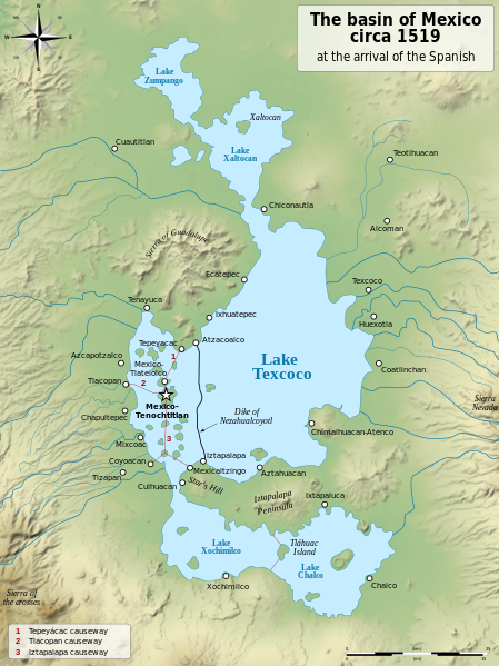
English: Map of the basin of Mexico circa 1519, at the arrival of the Spanish.
Español: Mapa de la cuenca de México acerca 1519, a la llegada de los españoles
Français : Carte du bassin de Mexico vers 1519, à l'arrivée des Espagnols. |
| Data | (UTC) |
| Burimi |
|
| Autori |
|
| Versione tjera |
[]
|
| SVG genesis |


| Camera location | | View this and other nearby images on: OpenStreetMap |
|---|
Licencim
Unë, krijuesi i kësaj pune, e publikoj këtu në bazë të licensës në vijim:
| Copyleft: Kjo punë arti është e lirë; ju mund ta rishpërndani dhe/ose modifikoni sipas kushteve të Free Art License. Jo do të gjeni një monstër të kësaj license tek sajti i Copyleft Attitude dhe në faqe të tjera interneti. |
This file is licensed under the Creative Commons Attribution-Share Alike Attribution-Share Alike 4.0 International, 3.0 Unported, 2.5 Generic, 2.0 Generic and 1.0 Generic license.
- Je i lirë të:
- ta shpërndani – ta kopjoni, rishpërndani dhe përcillni punën
- t’i bëni “remix” – të përshtatni punën
- Sipas kushteve të mëposhtme:
- atribuim – Duhet t’i jepni meritat e duhura, të siguroni një lidhje për tek licenca dhe të tregoni nëse janë bërë ndryshime. Këtë mund ta bëni në ndonjë mënyrë të arsyeshme, por jo në ndonjë mënyrë që sugjeron se licencuesi ju del zot juve apo përdorimit tuaj.
- share alike – Nëse bëni një “remix”, e shndërroni, ose ndërtoni duke u bazuar te materiali, duhet t’i shpërndani kontributet tuaja sipas të njëjtës licencë ose një të tille të përputhshme me origjinalen.
Mundeni të përzgjidhni licencën që doni.
Regjistri origjinal i ngarkimeve
This image is a derivative work of the following images:
- File:Lago_de_Texcoco-posclásico.png licensed with PD-self, PD-self/fr
- 2006-09-19T01:46:06Z Yavidaxiu 1412x1644 (344123 Bytes) {{Information |Description={{es|Mapa de la cuenca de México a la llegada de los españoles}} |Source=Trabajo propio |Date=18 de septiembre de 2006 |Author=Yavidaxiu |Permission={{PD-self}} |other_versions= }} [[Category:Map
- File:Valley_of_Mexico_c.1519-fr.svg licensed with Cc-by-sa-2.5,2.0,1.0, Cc-by-sa-3.0-migrated, GFDL
- 2007-09-11T14:00:14Z Historicair 731x849 (270643 Bytes)
- 2007-09-11T13:51:30Z Historicair 731x849 (272818 Bytes) {{Information |Description={{fr|Les environs de Tenochtitlan vers 1519}} {{en|Valley of Mexico circa 1519}} |Source=Own work |Date=11/09/2007 |Author=~~~~ |Permission={{self2|GFDL|cc-by-sa-2.5,2.0,1.0}} |other_versions= }} {{
Uploaded with derivativeFX
Historiku skedës
Shtypni mbi një datë/kohë për ta parë skedën siç ishte atëherë.
| Data/Koha | Miniaturë | Përmasat | Përdoruesi | Koment | |
|---|---|---|---|---|---|
| e tanishme | 28 janar 2021 22:29 | | 1.412 × 1.883 (526 KB) | Sémhur | Huexotla <=> Coatlinchán |
| 17 korrik 2013 07:40 |  | 1.412 × 1.883 (525 KB) | Citypeek | Enlargement of the legenda in the upper right corner. | |
| 17 korrik 2013 07:33 |  | 1.412 × 1.883 (533 KB) | Citypeek | Corrected two errors. Valid SVG now. | |
| 8 shkurt 2010 20:37 |  | 1.412 × 1.883 (533 KB) | Sémhur | + relief and some improvements | |
| 31 janar 2010 11:45 |  | 1.412 × 1.645 (99 KB) | Sémhur | == {{int:filedesc}} == {{Information |Description= {{en|Map of the basin of Mexico circa 1519, at the arrival of the Spanish.}} {{es|Mapa de la cuenca de México acerca 1519, a la llegada de los españoles}} {{fr|Carte du bassin de Mexico vers 1519, à l |
Lidhje skedash
Këto faqe lidhen tek kjo skedë:
Përdorimi global i skedës
Kjo skedë përdoret nga Wiki të tjera në vijim:
- Përdorimi në azb.wikipedia.org
- Përdorimi në ba.wikipedia.org
- Përdorimi në br.wikipedia.org
- Përdorimi në de.wikipedia.org
- Përdorimi në en.wikipedia.org
- Aztecs
- Iztapalapa
- Lake Texcoco
- Valley of Mexico
- Aztec Empire
- Altiplano Cundiboyacense
- Tenayuca
- User:Kazkaskazkasako/Books/History
- User:Maunus/sandbox
- List of conflicts in Mexico
- Lake Zumpango
- Lake Tauca
- User:SomeGuyWhoRandomlyEdits/List of conflicts in Mexico
- Sierra de Guadalupe, Mexico
- Battle of Colhuacatonco
- Përdorimi në en.wikibooks.org
- Përdorimi në es.wikipedia.org
- Përdorimi në fi.wikibooks.org
- Përdorimi në hr.wikipedia.org
- Përdorimi në hy.wikipedia.org
- Përdorimi në id.wikipedia.org
- Përdorimi në ja.wikipedia.org
- Përdorimi në ka.wikipedia.org
- Përdorimi në la.wikipedia.org
- Përdorimi në nl.wikipedia.org
- Përdorimi në nv.wikipedia.org
- Përdorimi në pl.wikipedia.org
- Përdorimi në rue.wikipedia.org
- Përdorimi në ru.wikipedia.org
- Përdorimi në sv.wikipedia.org
- Përdorimi në ta.wikipedia.org
- Përdorimi në tr.wikipedia.org
- Përdorimi në vi.wikipedia.org