
Skeda:Bcamazonica.jpg
Nuk ka përmasa më të madhaja.
Bcamazonica.jpg ((përmasa 800 × 578 px, madhësia skedës: 260 KB, lloji MIME: image/jpeg))
| Kjo skedë është prej Wikimedia Commons dhe mund të përdoret nga projekte të tjera. Përshkrimi në këtë skedë në këtë faqe nuk është treguar më poshtë. | Shko tek faqja përshkruese në Commons |

|
Kjo map fotografi duhet duhen te behen edhe i here si nje SVG.
|


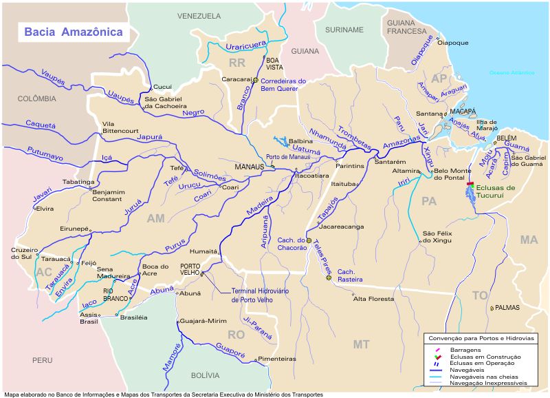
| Përshkrimi |
Português: O mapa mostra a região hidrográfica do Amazonas
English: Map showing the Amazonas watershed |
|||
| Burimi | https://web.archive.org/web/20090620080103/http://www.transportes.gov.br/bit/mapas/mapclick/hidro/bcamaz.htm | |||
| Autori | Secretaria Executiva do Ministério dos Transportes | |||
| Leja (Ripërdor këtë skedë) |
|
|||
| Versione tjera |
|


Historiku skedës
Shtypni mbi një datë/kohë për ta parë skedën siç ishte atëherë.
| Data/Koha | Miniaturë | Përmasat | Përdoruesi | Koment | |
|---|---|---|---|---|---|
| e tanishme | 18 prill 2005 20:19 | | 800 × 578 (260 KB) | Santana-freitas~commonswiki | Região Hidrográfica do Amazonas |
Lidhje skedash
S’ka faqe që përdorin këtë kartelë.
Përdorimi global i skedës
Kjo skedë përdoret nga Wiki të tjera në vijim:
- Përdorimi në af.wikipedia.org
- Përdorimi në ar.wikipedia.org
- Përdorimi në arz.wikipedia.org
- Përdorimi në azb.wikipedia.org
- Përdorimi në be.wikipedia.org
- Përdorimi në br.wikipedia.org
- Përdorimi në ca.wikipedia.org
- Përdorimi në ceb.wikipedia.org
- Përdorimi në de.wikipedia.org
- Përdorimi në en.wikipedia.org
- Përdorimi në es.wikipedia.org
- Usuario:Alvaro qc/Portada/1.0
- Usuario:Stormnight/Portada/1
- Usuario:NapoliAzzurro/portada2
- Usuario:MatNet
- Usuario:Xerq/Portada
- Río Vaupés
- Usuario:Cbastian/Datos
- Río Tacutu
- Wikipedia:¿Sabías que.../enero de 2008
- Wikipedia:¿Sabías que.../4 de enero de 2008
- Usuario:Leandro10 3
- Usuario:Zero spartan
- Wikipedia:¿Sabías que.../1
- Wikipedia:¿Sabías que.../2
- Usuario:ElBeTa
- Wikipedia:¿Sabías que.../Todos
Shikoni më shumë përdorim global të kësaj skede.