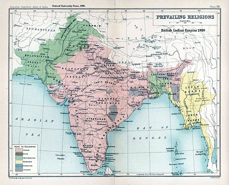
Skeda:Brit IndianEmpireReligions3.jpg
Appearance

Madhësia e këtij shikimi: 741 × 599 pixel. Rezolucione të tjera: 297 × 240 pixel | 593 × 480 pixel | 949 × 768 pixel | 1.266 × 1.024 pixel | 1.534 × 1.241 pixel.
Dokument origjinal ((përmasa 1.534 × 1.241 px, madhësia skedës: 2,33 MB, lloji MIME: image/jpeg))
Historiku skedës
Shtypni mbi një datë/kohë për ta parë skedën siç ishte atëherë.
| Data/Koha | Miniaturë | Përmasat | Përdoruesi | Koment | |
|---|---|---|---|---|---|
| e tanishme | 18 janar 2019 03:39 |  | 1.534 × 1.241 (2,33 MB) | Frank Klemm | Cropped, white balanced |
| 29 dhjetor 2011 14:27 |  | 1.504 × 1.232 (2,06 MB) | Maproom | Made colours less washed-out | |
| 11 shkurt 2009 02:20 |  | 1.504 × 1.232 (311 KB) | AnonMoos | losslessly cropping margins | |
| 21 shtator 2007 04:06 |  | 1.650 × 1.275 (330 KB) | Shooke | {{Information |Description=Map "Prevailing Religions of the British Indian Empire, 1909" from the Imperial Gazetteer of India, Oxford University Press, 1909. Scanned from personal copy and annotated by me ([[:en:User:Fowler&fowler|<font color="#B8860B">F |
Lidhje skedash
Këto faqe lidhen tek kjo skedë:
Përdorimi global i skedës
Kjo skedë përdoret nga Wiki të tjera në vijim:
- Përdorimi në af.wikipedia.org
- Përdorimi në ar.wikipedia.org
- Përdorimi në ast.wikipedia.org
- Përdorimi në az.wikipedia.org
- Përdorimi në ba.wikipedia.org
- Përdorimi në bg.wikipedia.org
- Përdorimi në bn.wikipedia.org
- Përdorimi në bn.wikiquote.org
- Përdorimi në ca.wikipedia.org
- Përdorimi në ckb.wikipedia.org
- Përdorimi në cs.wikipedia.org
- Përdorimi në de.wikipedia.org
- Përdorimi në diq.wikipedia.org
- Përdorimi në en.wikipedia.org
- History of India
- Kashmir
- Partition of India
- Gazetteer
- History of Hinduism
- Dominion of India
- British Raj
- User:Fowler&fowler
- Talk:History of Pakistan/History of the Pakistan region
- User:Fowler&fowler/Short History Indian Independence Movement
- User:Fowler&fowler/History of Pakistan
- History of the British Raj
- History of East Pakistan
- Talk:Jammu and Kashmir (state)/Archive 1
- User talk:RegentsPark/Archive 4
- User:Fowler&fowler/History of the Pakistan region
- Talk:British Raj/Archive 8
- User:Կիմա34/sandbox
- User:Falcaorib/India and Pakistan
- User:Fowler&fowler/British Raj
- Përdorimi në es.wikipedia.org
- Përdorimi në eu.wikipedia.org
- Përdorimi në fa.wikipedia.org
- Përdorimi në fr.wikipedia.org
Shikoni më shumë përdorim global të kësaj skede.


