Skeda:Cyprus BufferZoneInBlue.png
Appearance
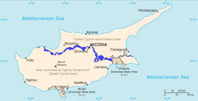
Cyprus_BufferZoneInBlue.png ((përmasa 630 × 321 px, madhësia skedës: 21 KB, lloji MIME: image/png))
Historiku skedës
Shtypni mbi një datë/kohë për ta parë skedën siç ishte atëherë.
| Data/Koha | Miniaturë | Përmasat | Përdoruesi | Koment | |
|---|---|---|---|---|---|
| e tanishme | 11 shkurt 2007 12:13 |  | 630 × 321 (21 KB) | Hoshie | {{english}} Map of Cyprus with the UN Buffer Zone in blue, the traditional color on maps for British possessions. The map is adapted from the [http://www.cia.gov/cia/publications/factbook/maps/cy-map.gif CIA World Factbook] map. |
Lidhje skedash
Këto faqe lidhen tek kjo skedë:
Përdorimi global i skedës
Kjo skedë përdoret nga Wiki të tjera në vijim:
- Përdorimi në ar.wikipedia.org
- Përdorimi në ca.wikipedia.org
- Resolució 472 del Consell de Seguretat de les Nacions Unides
- Resolució 482 del Consell de Seguretat de les Nacions Unides
- Resolució 486 del Consell de Seguretat de les Nacions Unides
- Resolució 510 del Consell de Seguretat de les Nacions Unides
- Resolució 526 del Consell de Seguretat de les Nacions Unides
- Resolució 544 del Consell de Seguretat de les Nacions Unides
- Resolució 553 del Consell de Seguretat de les Nacions Unides
- Resolució 634 del Consell de Seguretat de les Nacions Unides
- Resolució 680 del Consell de Seguretat de les Nacions Unides
- Resolució 697 del Consell de Seguretat de les Nacions Unides
- Resolució 1000 del Consell de Seguretat de les Nacions Unides
- Resolució 1283 del Consell de Seguretat de les Nacions Unides
- Resolució 1384 del Consell de Seguretat de les Nacions Unides
- Resolució 1687 del Consell de Seguretat de les Nacions Unides
- Resolució 1847 del Consell de Seguretat de les Nacions Unides
- Resolució 1953 del Consell de Seguretat de les Nacions Unides
- Resolució 1986 del Consell de Seguretat de les Nacions Unides
- Zona coixí
- Përdorimi në ckb.wikipedia.org
- بڕیارنامەی ٤٧٢ی ئەنجومەنی ئاسایش
- بڕیارنامەی ٤٨٢ی ئەنجومەنی ئاسایش
- بڕیارنامەی ٤٨٦ی ئەنجومەنی ئاسایش
- بڕیارنامەی ٤٩٥ی ئەنجومەنی ئاسایش
- بڕیارنامەی ٥١٠ی ئەنجومەنی ئاسایش
- بڕیارنامەی ٥٢٦ی ئەنجومەنی ئاسایش
- بڕیارنامەی ٥٤٤ی ئەنجومەنی ئاسایش
- بڕیارنامەی ٥٥٣ی ئەنجومەنی ئاسایش
- بڕیارنامەی ٥٥٩ی ئەنجومەنی ئاسایش
- بڕیارنامەی ٥٦٥ی ئەنجومەنی ئاسایش
- بڕیارنامەی ٥٧٨ی ئەنجومەنی ئاسایش
- بڕیارنامەی ٥٨٥ی ئەنجومەنی ئاسایش
- بڕیارنامەی ٥٩٣ی ئەنجومەنی ئاسایش
- بڕیارنامەی ٥٩٧ی ئەنجومەنی ئاسایش
- بڕیارنامەی ٦٠٤ی ئەنجومەنی ئاسایش
- بڕیارنامەی ٦١٤ی ئەنجومەنی ئاسایش
- بڕیارنامەی ٦٢٥ی ئەنجومەنی ئاسایش
- بڕیارنامەی ٦٣٤ی ئەنجومەنی ئاسایش
- بڕیارنامەی ٦٨٠ی ئەنجومەنی ئاسایش
- بڕیارنامەی ٦٩٧ی ئەنجومەنی ئاسایش
- بڕیارنامەی ٩٢٧ی ئەنجومەنی ئاسایش
- بڕیارنامەی ١٠٠٠ی ئەنجومەنی ئاسایش
- بڕیارنامەی ١٢٨٣ی ئەنجومەنی ئاسایش
- بڕیارنامەی ١٣٨٤ی ئەنجومەنی ئاسایش
- بڕیارنامەی ١٦٨٧ی ئەنجومەنی ئاسایش
- بڕیارنامەی ١٩٥٣ی ئەنجومەنی ئاسایش
- بڕیارنامەی ٢٠٢٦ی ئەنجومەنی ئاسایش
- ناوچەی جێناکۆک
- Përdorimi në da.wikipedia.org
Shikoni më shumë përdorim global të kësaj skede.


