
Skeda:EasternRomanEmpire.png
Nuk ka përmasa më të madhaja.
EasternRomanEmpire.png ((përmasa 250 × 175 px, madhësia skedës: 7 KB, lloji MIME: image/png))
| Kjo skedë është prej Wikimedia Commons dhe mund të përdoret nga projekte të tjera. Përshkrimi në këtë skedë në këtë faqe nuk është treguar më poshtë. | Shko tek faqja përshkruese në Commons |

|
This map has been uploaded by Electionworld from en.wikipedia.org to enable the |

|
The copyright holder of this work allows anyone to use it for any purpose including unrestricted redistribution, commercial use, and modification.
|
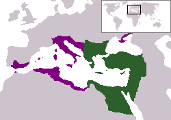
The territory in green represents the core areas held by the Eastern Roman Empire before the Muslim conquests The territory in purple represents the greatest extent of the Byzantine Empire under Emperor Justinian I
Historiku skedës
Shtypni mbi një datë/kohë për ta parë skedën siç ishte atëherë.
| Data/Koha | Miniaturë | Përmasat | Përdoruesi | Koment | |
|---|---|---|---|---|---|
| e tanishme | 13 dhjetor 2006 20:27 | | 250 × 175 (7 KB) | Electionworld | {{ew|en|24630}} {{CopyrightedFreeUse-User|24630}} The territory in green represents the core areas held by the Eastern Roman Empire before the Muslim conquests The territory in purple represents the greatest extent of the Byzantine Empire unde |
Lidhje skedash
Këto faqe lidhen tek kjo skedë:
Përdorimi global i skedës
Kjo skedë përdoret nga Wiki të tjera në vijim:
- Përdorimi në da.wikipedia.org
- Përdorimi në en.wiktionary.org
- Përdorimi në gd.wikipedia.org
- Përdorimi në lv.wikipedia.org
- Përdorimi në no.wikipedia.org
- Përdorimi në ru.wiktionary.org
- Përdorimi në sl.wikipedia.org
- Përdorimi në sv.wikipedia.org
- Përdorimi në vi.wikipedia.org
- Përdorimi në zh.wiktionary.org