
Skeda:Europe mediterranean 1190 cropped.jpg
Dokument origjinal ((përmasa 796 × 753 px, madhësia skedës: 257 KB, lloji MIME: image/jpeg))
| Kjo skedë është prej Wikimedia Commons dhe mund të përdoret nga projekte të tjera. Përshkrimi në këtë skedë në këtë faqe nuk është treguar më poshtë. | Shko tek faqja përshkruese në Commons |
Përmbledhje
| Përshkrimi |
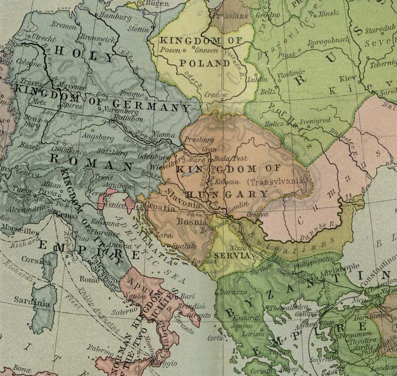
English: Map of Europe, ca. 1190 A.D. |
| Data | 1923 - 1926 |
| Burimi | Cropped from a map from the Historical Atlas by William Shepherd (1923–26), which is in the public domain in U.S. (http://www.lib.utexas.edu/maps/historical/shepherd/europe_mediterranean_1190.jpg) |
| Autori | William Shepherd |
| Versione tjera | Europe mediterranean 1190.jpg |
Licencim
|
This work is in the public domain in its country of origin and other countries and areas where the copyright term is the author's life plus 70 years or fewer.
| |
| Kjo skedë është identifikuar si e lirë e kufizimeve të panjohura në ligjin e të drejtave të autorit, duke përfshirë të gjitha të drejtat e lidhura dhe fqinje. | |
Regjistri origjinal i ngarkimeve
- 2009-05-27 11:46 Hobartimus 796×753× (263194 bytes) {{Information |Description = Map of europe, cropped ca. 1190 A.D. |Source = Shrinked version of a map from the ''Historical Atlas'' by William Shepherd (1923-26), which is in the public domain in U.S. ( http://www.lib.utexas.edu/maps/historic
Historiku skedës
Shtypni mbi një datë/kohë për ta parë skedën siç ishte atëherë.
| Data/Koha | Miniaturë | Përmasat | Përdoruesi | Koment | |
|---|---|---|---|---|---|
| e tanishme | 14 gusht 2011 16:48 | | 796 × 753 (257 KB) | File Upload Bot (Magnus Manske) | {{BotMoveToCommons|en.wikipedia|year={{subst:CURRENTYEAR}}|month={{subst:CURRENTMONTHNAME}}|day={{subst:CURRENTDAY}}}} {{Information |Description={{en|Map of europe, cropped ca. 1190 A.D.}} |Source=Transferred from [http://en.wikipedia.org en.wikipedia]; |
Lidhje skedash
Këto faqe lidhen tek kjo skedë:
Përdorimi global i skedës
Kjo skedë përdoret nga Wiki të tjera në vijim:
- Përdorimi në ar.wikipedia.org
- Përdorimi në ary.wikipedia.org
- Përdorimi në azb.wikipedia.org
- Përdorimi në bn.wikipedia.org
- Përdorimi në br.wikipedia.org
- Përdorimi në de.wikipedia.org
- Përdorimi në el.wikipedia.org
- Përdorimi në en.wikipedia.org
- Përdorimi në es.wikipedia.org
- Përdorimi në et.wikipedia.org
- Përdorimi në fa.wikipedia.org
- Përdorimi në fr.wikipedia.org
- Përdorimi në he.wikipedia.org
- Përdorimi në hu.wikipedia.org
- Përdorimi në id.wikipedia.org
- Përdorimi në id.wikibooks.org
- Përdorimi në io.wikipedia.org
- Përdorimi në it.wikipedia.org
Shikoni më shumë përdorim global të kësaj skede.