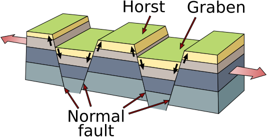
Skeda:Fault-Horst-Graben.svg
Appearance

Size of this PNG preview of this SVG file: 534 × 274 pixel. Rezolucione të tjera: 320 × 164 pixel | 640 × 328 pixel | 1.024 × 525 pixel | 1.280 × 657 pixel | 2.560 × 1.314 pixel.
Dokument origjinal (skedë SVG, fillimisht 534 × 274 pixel, madhësia e skedës: 18 KB)
Historiku skedës
Shtypni mbi një datë/kohë për ta parë skedën siç ishte atëherë.
| Data/Koha | Miniaturë | Përmasat | Përdoruesi | Koment | |
|---|---|---|---|---|---|
| e tanishme | 7 qershor 2011 12:19 |  | 534 × 274 (18 KB) | Gregors | Resized to objects |
| 7 qershor 2011 12:17 |  | 744 × 1.052 (18 KB) | Gregors | {{Information |Description={{de|Diagram zur geolog. Struktur von Horsten und Graben.}} {{en|geological structure of horst and graben.}} |Source=*File:Horst_graben.jpg |Date=2011-06-07 11:16 (UTC) |Author=*File:Horst_graben.jpg: U.S. Ge |
Lidhje skedash
Këto faqe lidhen tek kjo skedë:
Përdorimi global i skedës
Kjo skedë përdoret nga Wiki të tjera në vijim:
- Përdorimi në an.wikipedia.org
- Përdorimi në ca.wikipedia.org
- Përdorimi në de.wikipedia.org
- Përdorimi në en.wikipedia.org
- Përdorimi në en.wikiversity.org
- Përdorimi në en.wiktionary.org
- Përdorimi në eo.wikipedia.org
- Përdorimi në es.wikipedia.org
- Përdorimi në fa.wikipedia.org
- Përdorimi në fr.wikipedia.org
- Përdorimi në hi.wikipedia.org
- Përdorimi në hr.wikipedia.org
- Përdorimi në it.wikipedia.org
- Përdorimi në it.wikibooks.org
- Përdorimi në it.wikiversity.org
- Përdorimi në ja.wikipedia.org
- Përdorimi në ka.wikipedia.org
- Përdorimi në ko.wikipedia.org
- Përdorimi në ms.wikipedia.org
- Përdorimi në pl.wikipedia.org
- Përdorimi në pl.wiktionary.org
- Përdorimi në ro.wikipedia.org
- Përdorimi në sh.wikipedia.org
- Përdorimi në simple.wikipedia.org
- Përdorimi në sk.wikipedia.org
Shikoni më shumë përdorim global të kësaj skede.

