Skeda:Gibraltar map-en.svg
Page contents not supported in other languages.
Nga Wikipedia, enciklopedia e lirë

Dokument origjinal(skedë SVG, fillimisht 2.020 × 3.140 pixel, madhësia e skedës: 289 KB)

Kjo skedë është prej Wikimedia Commons dhe mund të përdoret nga projekte të tjera. Përshkrimi në këtë skedë në këtë faqe nuk është treguar më poshtë. Shko tek faqja përshkruese në Commons Shko tek faqja përshkruese në Commons

Imazh of the year
Imazh of the year
Featured imazh

Wikimedia Commons

This file was a candidate in Picture of the Year 2007.
This is a featured picture on Wikimedia Commons (Fotografi të Shkëlqyeshme) and is considered one of the finest images. See its nomination here.

If you have an image of similar quality that can be published under a suitable copyright license, be sure to upload it, tag it, and nominate it.

Përmbledhje

Camera location36° 08′ 00″ N, 5° 21′ 00″ W Kartographer map based on OpenStreetMap.View this and other nearby images on: OpenStreetMapinfo
Përshkrimi
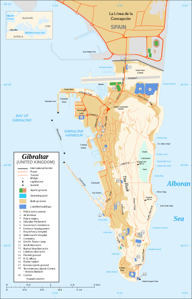
Čeština: Mapa ostrova Gibraltar v angličtině.
English: Map in English of Gibraltar.
Français : * Sujet : Carte en anglais de Gibraltar ;
  • Sources : Création personnelle ;
  • Carte créée à partir de captures d'écran d'images satellite de Google Earth d'un point de vue placé à 1,18 km d'altitude (imagerie disponible de novembre 2007) ;
  • Références complémentaires :
  • Échelle approximative : 1:40 000 (précision : environ 10 m) ;
  • Note : Largeur du tracé des routes proportionnelle à la réalité ;
  • Auteur : Eric Gaba (fr:Sting) ;
  • Date : Novembre 2007.
Português: Mapa (em Inglês) de Gibraltar.
Data
Burimi Own work ;
Map created using screenshots of Google Earth satellite imagery from a point of view located at 1.18 km of altitude (available imagery of November 2007) ;
Other references :
* CIA map ;
* Gibnet map ;
* U.K. MoD map
Locator map : Image:Blank_map_of_South_Europe_and_North_Africa.svg (modified) created by Historicair ;
Approximate scale : 1:40,000 (accuracy : about 10 m)
Note : The roads width is proportional to reality
Autori Eric Gaba (Sting)
Leja
(Ripërdor këtë skedë)
Attribution and Share-Alike required
Versione tjera

[redakto]

Disputed isthmus and land
SVG genesis
InfoField
 
The SVG code is valid.
 
This map was created with Inkscape…important.
 
 This map uses embedded text that can be easily translated using a text editor.

Licencim

Unë, krijuesi i kësaj pune, e publikoj këtu në bazë të licensës në vijim:
GNU head Ju jepet leje për ta kopjuar, shpërndarë dhe/ose ndryshuar këtë dokument sipas kushteve të Licencës GNU për Dokumentim të Lirë, versioni 1.2 ose çfarëdo versioni të mëpasshëm të botuar nga Free Software Foundation; pa Seksione të Pandryshueshme, pa Tekste Kapakësh të Përparmë, dhe pa Tekste Kapakësh të Pasmë. Një kopje e kësaj licence është përfshirë në seksionin e titulluar GNU Free Documentation License.
w:sq:Creative Commons
atribuim share alike
This file is licensed under the Creative Commons Attribution-Share Alike 4.0 International, 3.0 Unported, 2.5 Generic, 2.0 Generic and 1.0 Generic license.
Je i lirë të:
  • ta shpërndani – ta kopjoni, rishpërndani dhe përcillni punën
  • t’i bëni “remix” – të përshtatni punën
Sipas kushteve të mëposhtme:
  • atribuim – Duhet t’i jepni meritat e duhura, të siguroni një lidhje për tek licenca dhe të tregoni nëse janë bërë ndryshime. Këtë mund ta bëni në ndonjë mënyrë të arsyeshme, por jo në ndonjë mënyrë që sugjeron se licencuesi ju del zot juve apo përdorimit tuaj.
  • share alike – Nëse bëni një “remix”, e shndërroni, ose ndërtoni duke u bazuar te materiali, duhet t’i shpërndani kontributet tuaja sipas të njëjtës licencë ose një të tille të përputhshme me origjinalen.
Mundeni të përzgjidhni licencën që doni.

Captions

Add a one-line explanation of what this file represents

Items portrayed in this file

përshkruan

nëntor 2007

36°7'59.999"N, 5°21'0.000"W

image/svg+xml

Historiku skedës

Shtypni mbi një datë/kohë për ta parë skedën siç ishte atëherë.

Data/KohaMiniaturëPërmasatPërdoruesiKoment
e tanishme21 shkurt 2020 22:10Miniaturë për versionin duke filluar nga 21 shkurt 2020 22:102.020 × 3.140 (289 KB)JoKalliauermalformed svg (compare firefox/chrome rendering with librsvg-rendering) actually firefox/chrome were correct, also it looks wrong
29 qershor 2017 08:01Miniaturë për versionin duke filluar nga 29 qershor 2017 08:012.020 × 3.140 (538 KB)Wereldburger758Removal error in file. Valid SVG now.
27 gusht 2008 23:52Miniaturë për versionin duke filluar nga 27 gusht 2008 23:522.020 × 3.140 (569 KB)RedCoatRemove "claimed by Spain", completely gratuitous for a map
11 dhjetor 2007 13:28Miniaturë për versionin duke filluar nga 11 dhjetor 2007 13:282.020 × 3.140 (570 KB)StingNotification of the Spanish claims
27 nëntor 2007 16:40Miniaturë për versionin duke filluar nga 27 nëntor 2007 16:402.020 × 3.140 (569 KB)StingAdditional names ; up-to-date corrections
26 nëntor 2007 23:35Miniaturë për versionin duke filluar nga 26 nëntor 2007 23:352.020 × 3.140 (561 KB)RedCoatHouse of Assembly → Gibraltar Parliament
26 nëntor 2007 21:51Miniaturë për versionin duke filluar nga 26 nëntor 2007 21:512.020 × 3.140 (561 KB)Sting+ info
26 nëntor 2007 16:12Miniaturë për versionin duke filluar nga 26 nëntor 2007 16:122.020 × 3.140 (561 KB)Sting+ info
26 nëntor 2007 15:21Miniaturë për versionin duke filluar nga 26 nëntor 2007 15:212.020 × 3.140 (561 KB)Sting{{Information |Description=Map in English of Gibraltar |Source=Own work ;<br/>Map created using screenshots of Google Earth satellite imagery from a point of view located at 1.18 km of altitude (available image

S’ka faqe që përdorin këtë kartelë.

Përdorimi global i skedës

Kjo skedë përdoret nga Wiki të tjera në vijim:

Metadata