
Skeda:Gz-map.png
Nuk ka përmasa më të madhaja.
Gz-map.png ((përmasa 330 × 354 px, madhësia skedës: 13 KB, lloji MIME: image/png))
| Kjo skedë është prej Wikimedia Commons dhe mund të përdoret nga projekte të tjera. Përshkrimi në këtë skedë në këtë faqe nuk është treguar më poshtë. | Shko tek faqja përshkruese në Commons |
Përmbledhje
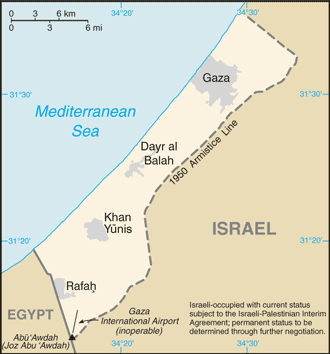
| Përshkrimi |
English: A map of the Gaza Strip showing key towns and neighbouring countries. |
|||
| Burimi | Gaza Strip from CIA factbook | |||
| Autori | CIA | |||
| Versione tjera |
[] Ver1:
Ver2:
|


Licencim
This image is in the public domain because it contains materials that originally came from the United States Central Intelligence Agency's World Factbook.
|
 |
Historiku skedës
Shtypni mbi një datë/kohë për ta parë skedën siç ishte atëherë.
| Data/Koha | Miniaturë | Përmasat | Përdoruesi | Koment | |
|---|---|---|---|---|---|
| e tanishme | 12 dhjetor 2008 12:24 | | 330 × 354 (13 KB) | Mattflaschen | Put back latest image from Factbook. This includes the note (don't know whether it was there on December 2, 2007). |
| 2 dhjetor 2007 04:17 |  | 328 × 352 (8 KB) | Kordas | Updated map | |
| 15 gusht 2005 20:12 |  | 328 × 352 (10 KB) | Mrmiscellanious~commonswiki | A map of the Gaza Strip showing key towns and neighbouring countries. Taken from CIA World Factbook website on 15 August 2005. Public domain, as is all content from the CIA factbook. | |
| 15 shtator 2004 14:37 |  | 330 × 355 (9 KB) | Robbot | This image was copied from en.wikipedia.org. The original description was: A map of the Gaza Strip showing key towns and neighbouring countries. Taken from CIA World Factbook website on 12 April. Public domain, as is all content from |
Lidhje skedash
S’ka faqe që përdorin këtë kartelë.
Përdorimi global i skedës
Kjo skedë përdoret nga Wiki të tjera në vijim:
- Përdorimi në be.wikipedia.org
- Përdorimi në bn.wikipedia.org
- Përdorimi në br.wikipedia.org
- Përdorimi në bs.wikipedia.org
- Përdorimi në bs.wikinews.org
- Përdorimi në ca.wikipedia.org
- Përdorimi në cs.wikinews.org
- Përdorimi në da.wikipedia.org
- Përdorimi në de.wikinews.org
- Përdorimi në en.wikipedia.org
- Përdorimi në en.wikinews.org
- Israeli army kills three Egyptians in border incident
- Abbas wins election, offers Israel 'hand of peace'
- Wikinews:2005/January
- Wikinews:2005/January/13
- K'nesset Member Natan Sharansky resigns from coalition government to protest planned Gaza withdrawal
- Israeli Air Force attacks targets in Gaza
- Israeli greenhouses to be preserved after Gaza pullout
- Gaza Strip pullout under way
- Israeli Army begins forced evacuation of Gaza settlements
- Palestinian gunmen assassinate ex-security chief
- Israel completing Gaza withdrawal
- Israel Defense Forces attack Gaza Strip
- Israel releases 90 Palestinian prisoners
- Israeli air strikes hit government compounds in Gaza
- Palestinian president pleads with UN Security Council for help in Gaza
- Përdorimi në en.wikivoyage.org
- Përdorimi në eo.wikipedia.org
- Përdorimi në es.wikipedia.org
- Përdorimi në es.wikinews.org
- Përdorimi në eu.wikipedia.org
- Përdorimi në fr.wikipedia.org
- Përdorimi në fr.wikinews.org
- Përdorimi në gl.wikipedia.org
- Përdorimi në he.wikipedia.org
- Përdorimi në he.wikinews.org
- Përdorimi në hr.wikipedia.org
Shikoni më shumë përdorim global të kësaj skede.