
Skeda:Indonesia 2002 CIA map.jpg
Madhësia e këtij shikimi: 800 × 536 pixel. Rezolucione të tjera: 320 × 214 pixel | 640 × 429 pixel | 1.024 × 686 pixel | 1.280 × 858 pixel | 2.000 × 1.340 pixel.
Dokument origjinal ((përmasa 2.000 × 1.340 px, madhësia skedës: 1,43 MB, lloji MIME: image/jpeg))
| Kjo skedë është prej Wikimedia Commons dhe mund të përdoret nga projekte të tjera. Përshkrimi në këtë skedë në këtë faqe nuk është treguar më poshtë. | Shko tek faqja përshkruese në Commons |
Përmbledhje
| Përshkrimi |
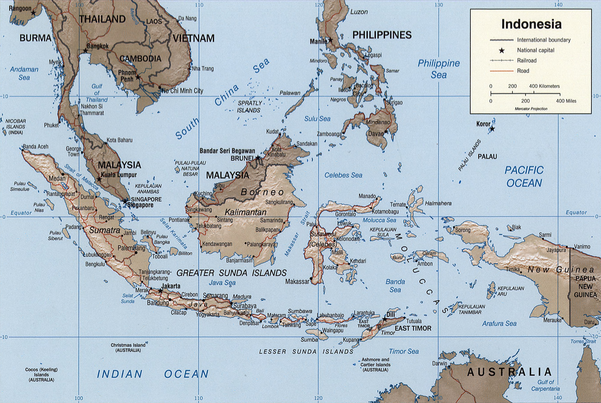
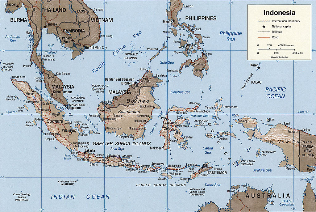
English: Map of Indonesia.
Français : Carte d'Indonésie. |
|||||||||||||||||||||||||
| Data | ||||||||||||||||||||||||||
| Burimi |
|
|||||||||||||||||||||||||
| Autori | Central Intelligence Agency, United States of America | |||||||||||||||||||||||||
| Versione tjera |
|
|||||||||||||||||||||||||


Licencim
| This image is a work of a Central Intelligence Agency employee, taken or made as part of that person's official duties. As a Work of the United States Government, this image or media is in the public domain in the United States.
|

|
Original description
Indonesia.
United States. Central Intelligence Agency.
CREATED/PUBLISHED
[Washington, D.C. : Central Intelligence Agency, 2002]
NOTES
Relief shown by shading.
"Base 802899AI (C00429) 11-02."
Also issued without shaded relief.
Scale [ca. 1:25,000,000] ; Mercator proj. (E 1040--E 1430/N 170--S 150).
SUBJECTS
MEDIUM
1 map : col. ; 16 x 23 cm.
CALL NUMBER
G8070 2002 .U6
REPOSITORY
Library of Congress Geography and Map Division Washington, D.C. 20540-4650 USA
DIGITAL ID
g8070 ct000982 http://hdl.loc.gov/loc.gmd/g8070.ct000982
Historiku skedës
Shtypni mbi një datë/kohë për ta parë skedën siç ishte atëherë.
| Data/Koha | Miniaturë | Përmasat | Përdoruesi | Koment | |
|---|---|---|---|---|---|
| e tanishme | 26 tetor 2005 05:39 | | 2.000 × 1.340 (1,43 MB) | Brian0918 | Indonesia. United States. Central Intelligence Agency. CREATED/PUBLISHED [Washington, D.C. : Central Intelligence Agency, 2002] NOTES Relief shown by shading. "Base 802899AI (C00429) 11-02." Also issued without shaded relief. Scale [ca. 1:25,000,000 |
Lidhje skedash
Këto faqe lidhen tek kjo skedë:
Përdorimi global i skedës
Kjo skedë përdoret nga Wiki të tjera në vijim:
- Përdorimi në ace.wikipedia.org
- Përdorimi në ar.wikipedia.org
- Përdorimi në azb.wikipedia.org
- Përdorimi në az.wikipedia.org
- Përdorimi në bcl.wikipedia.org
- Përdorimi në bg.wikipedia.org
- Përdorimi në bs.wikipedia.org
- Përdorimi në da.wikipedia.org
- Përdorimi në de.wikipedia.org
- Përdorimi në el.wikipedia.org
- Përdorimi në en.wikipedia.org
- Përdorimi në eo.wikipedia.org
- Përdorimi në es.wikipedia.org
- Përdorimi në eu.wikipedia.org
- Përdorimi në fi.wikipedia.org
- Përdorimi në frr.wikipedia.org
- Përdorimi në fr.wikipedia.org
- Përdorimi në fr.wiktionary.org
- Përdorimi në gl.wikipedia.org
- Përdorimi në he.wikipedia.org
- Përdorimi në hy.wikipedia.org
- Përdorimi në id.wikipedia.org
- Përdorimi në id.wikisource.org
- Përdorimi në is.wikipedia.org
- Përdorimi në ja.wikipedia.org
- Përdorimi në ka.wikipedia.org
- Përdorimi në kk.wikipedia.org
- Përdorimi në mg.wikipedia.org
- Përdorimi në ms.wikipedia.org
- Përdorimi në mt.wikipedia.org
- Përdorimi në nn.wikipedia.org
- Përdorimi në pl.wikipedia.org
- Përdorimi në pl.wiktionary.org
- Përdorimi në pt.wikipedia.org
Shikoni më shumë përdorim global të kësaj skede.