
Skeda:Kobe Port Tower and Maritime Museum, November 2016.jpg
Madhësia e këtij shikimi: 688 × 600 pixel. Rezolucione të tjera: 275 × 240 pixel | 551 × 480 pixel | 881 × 768 pixel | 1.174 × 1.024 pixel | 2.349 × 2.048 pixel | 3.492 × 3.045 pixel.
Dokument origjinal ((përmasa 3.492 × 3.045 px, madhësia skedës: 6,77 MB, lloji MIME: image/jpeg))
| Kjo skedë është prej Wikimedia Commons dhe mund të përdoret nga projekte të tjera. Përshkrimi në këtë skedë në këtë faqe nuk është treguar më poshtë. | Shko tek faqja përshkruese në Commons |
Përmbledhje
| Përshkrimi |
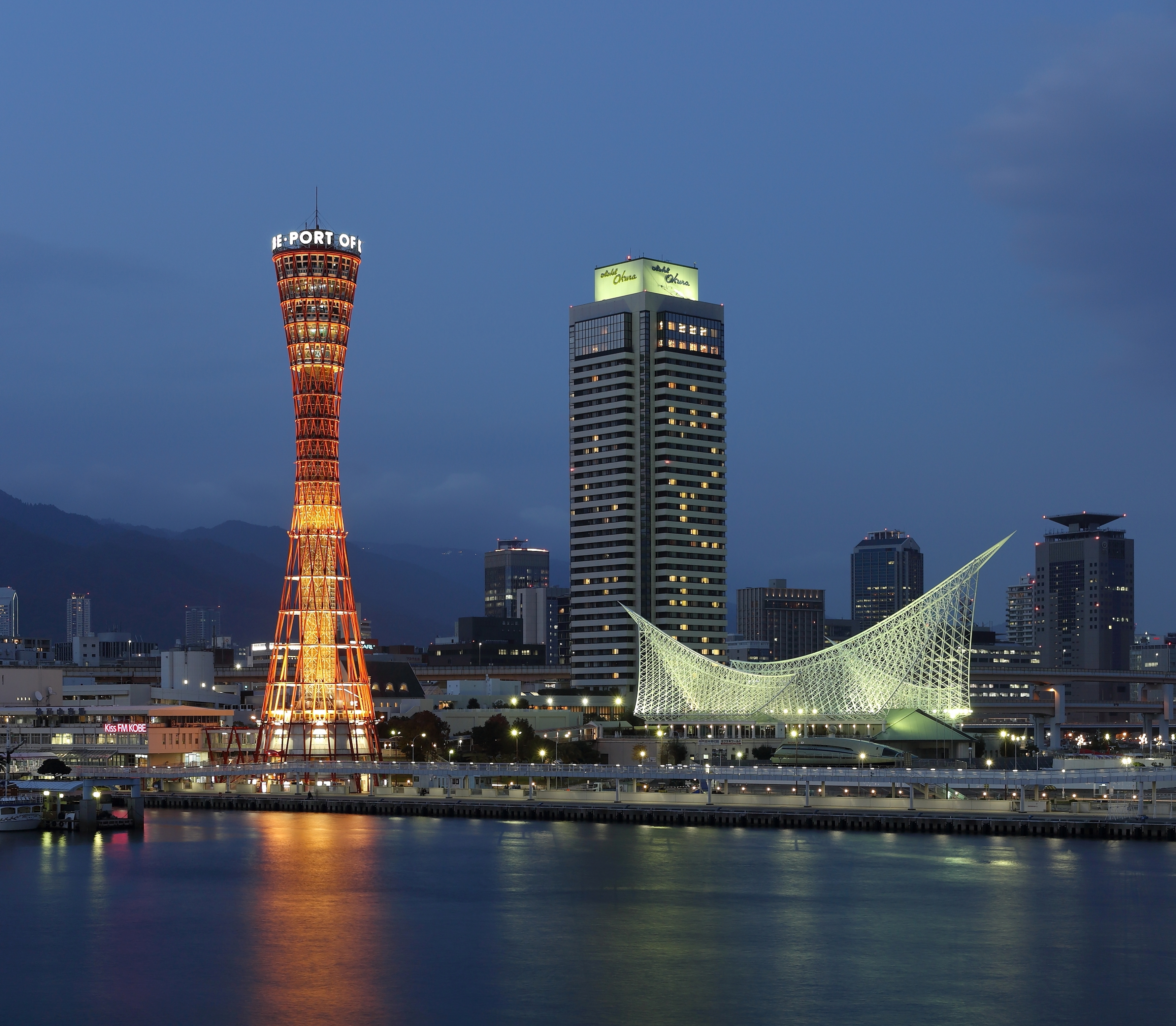
Français : Vue de la ville de Kobe, au Japon, depuis son port. On peut voir à gauche la Kōbe Pōto Tawā (Tour du port de Kobe), lieu touristique achevé en 1963, l'un des éléments marquants de la ville, et plus bas à droite le musée maritime, qui retrace l'histoire maritime japonaise en générale et celle du port de Kobe en particulier.
Polski: Port Kobe: po lewej stronie widoczna jest podświetlona wieża widokowa (ang. Kobe Port Tower), a po prawej podświetlony budynek Muzeum Morskiego (ang. Kobe Maritime Museum).
Български: Пристанищнaта кула в Кобе е една от най-известните забележителности в Кобе, Япония. Строежът на кулата е завършен през 1963 г. Тук в ляво от кулата се вижда и интересната форма на Музея на мореплаването на Кобе, посветен на корабоплаването в Япония и на пристанището на Кобе.
Čeština: Přístavní věž v Kóbe je jednou z dominant japonského města Kóbe. Tato vyhlídková věž byla dostavěna v roce 1963. Námořní muzeum v Kóbe je zaměřeno na dějiny japonského námořnictva a zvláště na přístav Kóbe.
Español: La torre del puerto de Kobe es uno de los hitos en la ciudad de Kobe, Japón. La torre panorámica se completó en 1963. El Museo Marítimo de Kobe se centra en la historia de la navegación japonesa en general y el puerto de Kobe en particular.
|
|||||||||||||||||
| Data | ||||||||||||||||||
| Burimi | Punë e juaja | |||||||||||||||||
| Autori |
|
|||||||||||||||||

| Camera location | | View this and other nearby images on: OpenStreetMap |
|---|
Assessment
This image was selected as picture of the day on Wikimedia Commons for 6 July 2017. It was captioned as follows: English: The Kobe Port Tower is one of the landmarks in the city of Kobe, Japan. The sightseeing tower was completed in 1963. The Kobe Maritime Museum is focusing on the history of Japanese shipping in general and Kobe harbor in particular. Other languages:
Čeština: Přístavní věž v Kóbe je jednou z dominant japonského města Kóbe. Tato vyhlídková věž byla dostavěna v roce 1963. Námořní muzeum v Kóbe je zaměřeno na dějiny japonského námořnictva a zvláště na přístav Kóbe. English: The Kobe Port Tower is one of the landmarks in the city of Kobe, Japan. The sightseeing tower was completed in 1963. The Kobe Maritime Museum is focusing on the history of Japanese shipping in general and Kobe harbor in particular. Español: La torre del puerto de Kobe es uno de los hitos en la ciudad de Kobe, Japón. La torre panorámica se completó en 1963. El Museo Marítimo de Kobe se centra en la historia de la navegación japonesa en general y el puerto de Kobe en particular. Français : Vue de la ville de Kobe, au Japon, depuis son port. On peut voir à gauche la Kōbe Pōto Tawā (Tour du port de Kobe), lieu touristique achevé en 1963, l'un des éléments marquants de la ville, et plus bas à droite le musée maritime, qui retrace l'histoire maritime japonaise en générale et celle du port de Kobe en particulier. Polski: Zbudowana w 1963 roku wieża widokowa w porcie Kobe, jednen z punktów charakterystycznych miasta Kobe w Japonii. Po prawej stronie widoczny jest podświetlony budynek Muzeum Morskiego, które koncentruje się na historii japońskiej żeglugi, a w szczególności na porcie Kobe. Български: Пристанищнaта кула в Кобе е една от най-известните забележителности в Кобе, Япония. Строежът на кулата е завършен през 1963 г. Тук в ляво от кулата се вижда и интересната форма на Музея на мореплаването на Кобе, посветен на корабоплаването в Япония и на пристанището на Кобе. |
|

|
This image has been assessed under the valued image criteria and is considered the most valued image on Commons within the scope: Kobe Port Tower at night with Maritime Museum. You can see its nomination here. |
Licencim
Unë, krijuesi i kësaj pune, e publikoj këtu në bazë të licensës në vijim:
This file is licensed under the Creative Commons Attribution-Share Alike 4.0 International license.
- Je i lirë të:
- ta shpërndani – ta kopjoni, rishpërndani dhe përcillni punën
- t’i bëni “remix” – të përshtatni punën
- Sipas kushteve të mëposhtme:
- atribuim – Duhet t’i jepni meritat e duhura, të siguroni një lidhje për tek licenca dhe të tregoni nëse janë bërë ndryshime. Këtë mund ta bëni në ndonjë mënyrë të arsyeshme, por jo në ndonjë mënyrë që sugjeron se licencuesi ju del zot juve apo përdorimit tuaj.
- share alike – Nëse bëni një “remix”, e shndërroni, ose ndërtoni duke u bazuar te materiali, duhet t’i shpërndani kontributet tuaja sipas të njëjtës licencë ose një të tille të përputhshme me origjinalen.
| Annotations | This image is annotated: View the annotations at Commons |
Historiku skedës
Shtypni mbi një datë/kohë për ta parë skedën siç ishte atëherë.
| Data/Koha | Miniaturë | Përmasat | Përdoruesi | Koment | |
|---|---|---|---|---|---|
| e tanishme | 23 dhjetor 2016 21:11 | | 3.492 × 3.045 (6,77 MB) | Martin Falbisoner | better crop |
| 30 nëntor 2016 09:51 |  | 2.940 × 3.433 (6,53 MB) | Martin Falbisoner | Cropped 12 % vertically using CropTool with lossless mode. | |
| 30 nëntor 2016 09:47 |  | 2.940 × 3.921 (7,27 MB) | Martin Falbisoner | User created page with UploadWizard |
Lidhje skedash
Këto faqe lidhen tek kjo skedë:
Përdorimi global i skedës
Kjo skedë përdoret nga Wiki të tjera në vijim:
- Përdorimi në ace.wikipedia.org
- Përdorimi në be-tarask.wikipedia.org
- Përdorimi në ca.wikipedia.org
- Përdorimi në crh.wikipedia.org
- Përdorimi në cv.wikipedia.org
- Përdorimi në de.wikipedia.org
- Përdorimi në en.wikipedia.org
- Përdorimi në es.wikipedia.org
- Përdorimi në fr.wikipedia.org
- Përdorimi në hu.wikipedia.org
- Përdorimi në hy.wikipedia.org
- Përdorimi në ie.wikipedia.org
- Përdorimi në ka.wikipedia.org
- Përdorimi në ko.wikipedia.org
- Përdorimi në krc.wikipedia.org
- Përdorimi në lbe.wikipedia.org
- Përdorimi në lez.wikipedia.org
- Përdorimi në mdf.wikipedia.org
- Përdorimi në mk.wikipedia.org
- Përdorimi në mt.wikipedia.org
- Përdorimi në my.wikipedia.org
- Përdorimi në nn.wikipedia.org
- Përdorimi në os.wikipedia.org
- Përdorimi në pt.wikipedia.org
- Përdorimi në ru.wikipedia.org
- Përdorimi në ru.wikinews.org
- Përdorimi në sah.wikipedia.org
- Përdorimi në sl.wikipedia.org
- Përdorimi në sv.wikipedia.org
- Përdorimi në tr.wikipedia.org
- Përdorimi në tyv.wikipedia.org
- Përdorimi në udm.wikipedia.org
- Përdorimi në uk.wikipedia.org
- Përdorimi në vep.wikipedia.org
- Përdorimi në xal.wikipedia.org
- Përdorimi në zh.wikipedia.org