
Skeda:Location Utrechtse Vecht.PNG

Madhësia e këtij shikimi: 450 × 599 pixel. Rezolucione të tjera: 180 × 240 pixel | 580 × 772 pixel.
Dokument origjinal ((përmasa 580 × 772 px, madhësia skedës: 77 KB, lloji MIME: image/png))
| Kjo skedë është prej Wikimedia Commons dhe mund të përdoret nga projekte të tjera. Përshkrimi në këtë skedë në këtë faqe nuk është treguar më poshtë. | Shko tek faqja përshkruese në Commons |
Përmbledhje
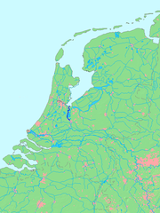
Utrechtse Vecht
| Përshkrimi | Location of a waterway (river/canal) in the Netherlends |
| Burimi | based on image File:MapNetherlandsWater.PNG |
| Autori | edited by M.Minderhoud |
Licencim
This image is in the public domain because it came from the site https://www.demis.nl/products/web-map-server/examples/ and was released by the copyright holder. Permission is granted to copy, distribute and/or modify this map since it is based on free of copyright images from: www.demis.nl. See also approval email on de.wp and its clarification.
|
| This work has been released into the public domain by its copyright holder, www.demis.nl. This applies worldwide. Në disa vende kjo mund të mos jetë e mundur ligjërisht; nëse është kështu: www.demis.nl i garanton çdokujt të drejtën për ta përdorur këtë punë për çdo qëllim, pa asnjë kusht, përveç rasteve kur këto kushte janë të kërkuara nga ligji.
|
Historiku skedës
Shtypni mbi një datë/kohë për ta parë skedën siç ishte atëherë.
| Data/Koha | Miniaturë | Përmasat | Përdoruesi | Koment | |
|---|---|---|---|---|---|
| e tanishme | 16 tetor 2005 17:15 | | 580 × 772 (77 KB) | Michiel1972 | Utrechtse Vecht {{dutchwaterwaymap}} |
Lidhje skedash
S’ka faqe që përdorin këtë kartelë.
Përdorimi global i skedës
Kjo skedë përdoret nga Wiki të tjera në vijim:
- Përdorimi në arz.wikipedia.org
- Përdorimi në de.wikipedia.org
- Përdorimi në de.wikivoyage.org
- Përdorimi në fr.wikipedia.org
- Përdorimi në fy.wikipedia.org
- Përdorimi në nl.wikipedia.org
- Përdorimi në nn.wikipedia.org
- Përdorimi në sh.wikipedia.org
- Përdorimi në vls.wikipedia.org
- Përdorimi në www.wikidata.org