
Skeda:MH370 SearchAreaMap June 2014.jpg
Dokument origjinal ((përmasa 3.508 × 2.480 px, madhësia skedës: 5,47 MB, lloji MIME: image/jpeg))
| Kjo skedë është prej Wikimedia Commons dhe mund të përdoret nga projekte të tjera. Përshkrimi në këtë skedë në këtë faqe nuk është treguar më poshtë. | Shko tek faqja përshkruese në Commons |
Përmbledhje
| Përshkrimi |
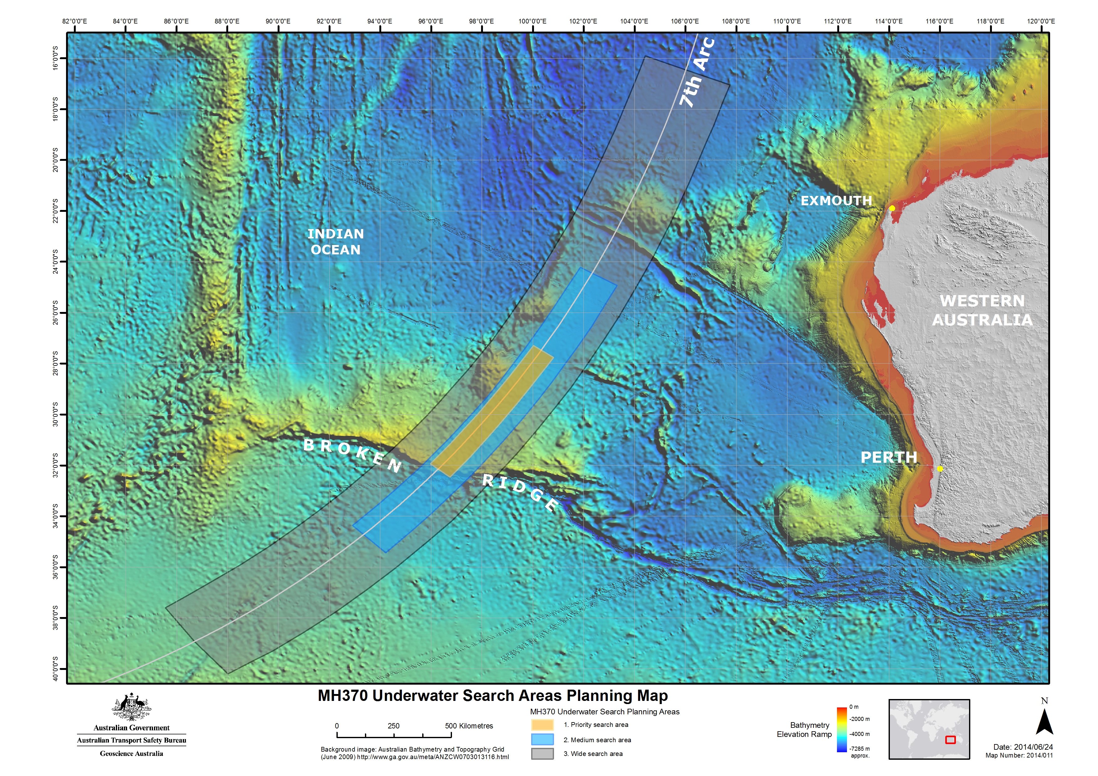
English: Map of the region to be searched for Malaysia Airlines Flight 370 announced 26 June 2014. The searching of this region is expected to begin in August 2014 and take up to 12 months to complete. Note on the background image some tracks of higher resolution bathymetric data, which had been obtained from soundings by passing ships. |
| Data | |
| Burimi | [1] |
| Autori | Australian Transport Safety Bureau |
| Leja (Ripërdor këtë skedë) |
Note:All three versions uploaded are identical, which includes the date (2014/06/24) and "Map number" (2014/011). The only difference is the pixel size. The third version (4 October 2014) uploaded is from the ATSB website, which states on the "Copyright" page: "Apart from the Coat of Arms, the ATSB logo, photos and graphics in which a third party has copyright, our investigation reports are licensed under the Creative Commons Attribution 3.0 Australia Licence." The second version (30 July 2014) uploaded was extracted from a report by the ATSB which states (pg. 2): "With the exception of the Coat of Arms, ATSB logo, and photos and graphics in which a third party holds copyright, this publication is licensed under a Creative Commons Attribution 3.0 Australia license." The background bathymetric image comes from here, listing "Access constraints: No restrictions". Per the Geoscience Australia website: "Unless otherwise noted, all Geoscience Australia material on this website is licensed under the Creative Commons Attribution 3.0 Australia Licence." The original version (27 June 2014) was obtained from JACC (a link from this press release) because I was unable to figure out, at the time, how to extract the image from the ATSB report (PDF). The JACC claimed copyright to content on its website, but the image was seemingly identical (visual appearance & id number: "Map 2014/011") to the map in the ATSB report, which was later uploaded. |
Licencim
- Je i lirë të:
- ta shpërndani – ta kopjoni, rishpërndani dhe përcillni punën
- t’i bëni “remix” – të përshtatni punën
- Sipas kushteve të mëposhtme:
- atribuim – Duhet t’i jepni meritat e duhura, të siguroni një lidhje për tek licenca dhe të tregoni nëse janë bërë ndryshime. Këtë mund ta bëni në ndonjë mënyrë të arsyeshme, por jo në ndonjë mënyrë që sugjeron se licencuesi ju del zot juve apo përdorimit tuaj.

Historiku skedës
Shtypni mbi një datë/kohë për ta parë skedën siç ishte atëherë.
| Data/Koha | Miniaturë | Përmasat | Përdoruesi | Koment | |
|---|---|---|---|---|---|
| e tanishme | 4 tetor 2014 05:59 | | 3.508 × 2.480 (5,47 MB) | AHeneen | Higher resolution obtained from ATSB website. |
| 30 korrik 2014 03:17 |  | 1.514 × 1.070 (299 KB) | AHeneen | Higher resolution image. Extracted from ATSB report. | |
| 27 qershor 2014 04:25 |  | 1.024 × 724 (436 KB) | AHeneen | User created page with UploadWizard |
Lidhje skedash
S’ka faqe që përdorin këtë kartelë.
Përdorimi global i skedës
Kjo skedë përdoret nga Wiki të tjera në vijim:
- Përdorimi në de.wikipedia.org
- Përdorimi në en.wikipedia.org
- Përdorimi në tr.wikipedia.org
- Përdorimi në vi.wikipedia.org
- Përdorimi në www.wikidata.org