
Skeda:Map Europe alliances 1914-fr.svg

Size of this PNG preview of this SVG file: 800 × 475 pixel. Rezolucione të tjera: 320 × 190 pixel | 640 × 380 pixel | 1.024 × 608 pixel | 1.280 × 761 pixel | 2.560 × 1.521 pixel | 998 × 593 pixel.
Dokument origjinal (skedë SVG, fillimisht 998 × 593 pixel, madhësia e skedës: 98 KB)
| Kjo skedë është prej Wikimedia Commons dhe mund të përdoret nga projekte të tjera. Përshkrimi në këtë skedë në këtë faqe nuk është treguar më poshtë. | Shko tek faqja përshkruese në Commons |
| Përshkrimi |
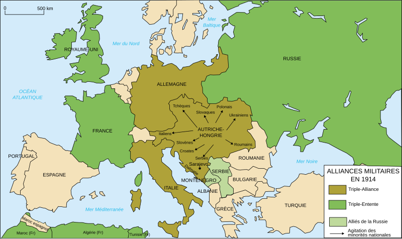
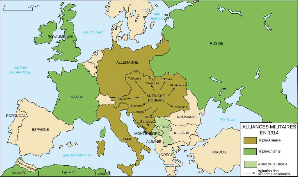
Deutsch: Karte von Militärbündnisse in Europa in 1914, (Französische)
English: Map of military alliances of Europe in 1914. (French)
Français : Carte des alliances militaires en Europe en 1914. (Français)
Русский: Схема военных альянсов в Европе в 1914 г. (фр.) |
||||||||
| Data | à 15:08 (UTC) | ||||||||
| Burimi |
Français : Création personnelle (version renommée de Image:Les rivalités en Europe en 1914.svg) |
||||||||
| Autori | historicair | ||||||||
| Leja (Ripërdor këtë skedë) |
Unë, krijuesi i kësaj pune, e publikoj këtu në bazë të licensës në vijim:
Kjo skedë është dhënë për përdorim sipas licensës Creative Commons Attribution-Share Alike 2.5 Generic, 2.0 Generic dhe 1.0 Generic.
Mundeni të përzgjidhni licencën që doni. |
||||||||
| Versione tjera |
[]
|

.gif)


|
Kjo skedë SVG përdor tekst i cili mund të përkthehet fare lehtë në gjuhën tënde përmes [toolforge:svgtranslate/File:Map_Europe_alliances_1914-fr.svglink këtij mjeti] në mënyrë automatike. Lexo më tepër. Gjithashtu ju mund ta shkarkoni këtë skedar dhe ta redaktoni manualisht përmes një tekst-editori. |
Historiku skedës
Shtypni mbi një datë/kohë për ta parë skedën siç ishte atëherë.
| Data/Koha | Miniaturë | Përmasat | Përdoruesi | Koment | |
|---|---|---|---|---|---|
| e tanishme | 2 janar 2015 14:27 | | 998 × 593 (98 KB) | Borodun | Moonsund archipelago is territory of Russia |
| 13 janar 2009 12:42 |  | 998 × 593 (98 KB) | Bibi Saint-Pol | typo | |
| 27 shkurt 2007 01:36 |  | 998 × 593 (98 KB) | Bibi Saint-Pol | {{Information |Description= {{fr|Carte des alliances militaires en Europe en 1914.}} |Source=Création personnelle (version renommée de Image:Les rivalités en Europe en 1914.svg) |Date=2006-10-31 |Author=historicair, 2006-31-10 |
Lidhje skedash
S’ka faqe që përdorin këtë kartelë.
Përdorimi global i skedës
Kjo skedë përdoret nga Wiki të tjera në vijim:
- Përdorimi në de.wikipedia.org
- Përdorimi në fr.wikipedia.org
- Première Guerre mondiale
- Triplice
- Triple-Entente
- Alpes dinariques
- Relations entre l'Allemagne et la France
- Alliés de la Première Guerre mondiale
- Wikipédia:Atelier graphique/Images à améliorer/Archives/Mars 2008
- Pays impliqués dans la Première Guerre mondiale
- Front de l'Est (Première Guerre mondiale)
- Antonino Paternò-Castello
- Liste historique des régions et pays par PIB
- Wikipédia:Atelier graphique/Cartes/Archives/juillet 2012
- Utilisateur:Pablo31100/Les causes profondes de la première guerre mondiale
- Relations entre la France et la Russie
- Causes de la Première Guerre mondiale
- Alliance militaire
- Përdorimi në fr.wikibooks.org
- Përdorimi në fr.wikiversity.org
- Përdorimi në it.wikipedia.org
- Përdorimi në tt.wikipedia.org
- Përdorimi në wo.wikipedia.org