
Skeda:Paneuropetransport.png

Madhësia e këtij shikimi: 492 × 600 pixel. Rezolucione të tjera: 197 × 240 pixel | 394 × 480 pixel | 773 × 942 pixel.
Dokument origjinal ((përmasa 773 × 942 px, madhësia skedës: 32 KB, lloji MIME: image/png))
| Kjo skedë është prej Wikimedia Commons dhe mund të përdoret nga projekte të tjera. Përshkrimi në këtë skedë në këtë faqe nuk është treguar më poshtë. | Shko tek faqja përshkruese në Commons |
Përmbledhje

|
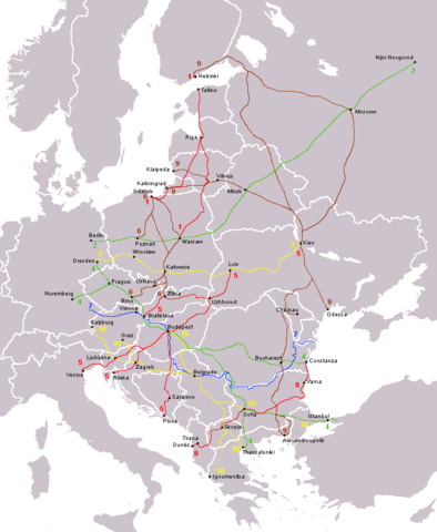
File:Pan-European corridors.svg is a vector version of this file. It should be used in place of this PNG file when not inferior.
File:Paneuropetransport.png → File:Pan-European corridors.svg
For more information, see Help:SVG. |
 |
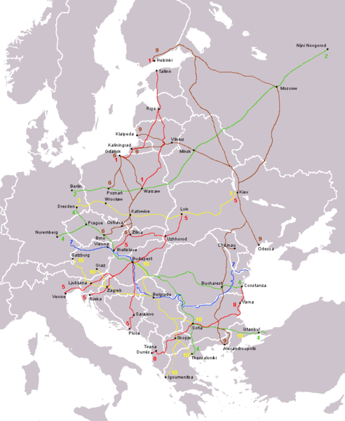
The ten Pan-European transport corridors.
Created by User:Albinfo using User:wiki-vr's blank map.
derivative works
Derivative works of this file: Pan-European corridors.svg
Licencim
| Unë,krijuesi i kësaj pune, e lëshoj këtë punë në public domain. Kjo aplikohet në të gjithë botën. Në disa vende kjo mund të mos jetë e mundur ligjërisht; nëse është kështu: Unë i garantoj çdokujt të drejtën për ta përdorur këtë punë për çdo qëllim, pa asnjë kusht, përveç rasteve kur këto kushte janë të kërkuara nga ligji. |
Historiku skedës
Shtypni mbi një datë/kohë për ta parë skedën siç ishte atëherë.
| Data/Koha | Miniaturë | Përmasat | Përdoruesi | Koment | |
|---|---|---|---|---|---|
| e tanishme | 14 gusht 2013 15:15 | | 773 × 942 (32 KB) | Spiridon Ion Cepleanu | Little rectifications around low-Danube |
| 18 tetor 2007 10:05 |  | 773 × 942 (44 KB) | Hoshie | added Montenegro. Under same lic. as before. | |
| 13 dhjetor 2006 01:11 |  | 773 × 942 (37 KB) | Albinfo | Fixed several errors and updated corrections in the original file - sorry for all the misleadings | |
| 5 dhjetor 2006 22:06 |  | 773 × 941 (33 KB) | Geo-Loge~commonswiki | Ostrava => Brno, Ostrava added, Wroclaw and Krakow added | |
| 24 qershor 2006 19:12 |  | 773 × 941 (28 KB) | Joy | Fixed confusion between Lviv and Uzhorod. | |
| 31 dhjetor 2005 00:42 |  | 773 × 941 (36 KB) | Albinfo | The ten Pan-European transport corridors. Created by User:Albinfo using User:wiki-vr's blank map. |
Lidhje skedash
S’ka faqe që përdorin këtë kartelë.
Përdorimi global i skedës
Kjo skedë përdoret nga Wiki të tjera në vijim:
- Përdorimi në be.wikipedia.org
- Përdorimi në cs.wikipedia.org
- Përdorimi në de.wikipedia.org
- Përdorimi në eo.wikipedia.org
- Përdorimi në es.wikipedia.org
- Përdorimi në fr.wikipedia.org
- Përdorimi në sr.wikipedia.org
- Përdorimi në sv.wikipedia.org