
Skeda:Pind-Meglen.png
Nuk ka përmasa më të madhaja.
Pind-Meglen.png ((përmasa 200 × 204 px, madhësia skedës: 23 KB, lloji MIME: image/png))
| Kjo skedë është prej Wikimedia Commons dhe mund të përdoret nga projekte të tjera. Përshkrimi në këtë skedë në këtë faqe nuk është treguar më poshtë. | Shko tek faqja përshkruese në Commons |
Përmbledhje
| Përshkrimi |
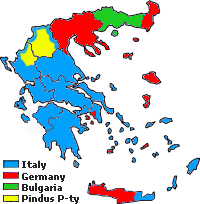
Approximative area (yellow) proposed by Alcibiades Diamandi for an eventual puppet-state called "Principality of the Pindus" in northern Greece under Italian occupation (this name was initially used in 1917 for another similar italian project). Diamandi's attempt of statehood had neither definite territory nor any borders, and never came close to realization; the yellow area in this map is likely to cover the maximalist area of the "Principality". |
| Burimi | Punë e juaja, since a hand-drawn boundary (1942 or 1943) surimposed on a map of the Aromanians areas in Balkans, found & seen in the library of the Military Museum of Bucharest. |
| Autori | Spiridon MANOLIU |
Licencim
| Kjo skedë është bërë e mundur nën Creative Commons CC0 1.0 Universal Public Domain Dedication. | |
| Personi që lidhi një punë me këtë vepër ia ka dedikuar punën public domain duke shmangur të gjitha të drejtat e tij apo të saj për punën në mbarë botën nën ligjin e të drejtës së autorit, duke përfshirë të gjitha të drejtat e lidhura dhe fqinje, deri në masën e lejuar me ligj. Ju mund ta kopjoni, modifikoni, shpërndani dhe të kryeni pune, madje edhe për qëllime komerciale, të gjitha pa kërkuar leje.
|
Historiku skedës
Shtypni mbi një datë/kohë për ta parë skedën siç ishte atëherë.
| Data/Koha | Miniaturë | Përmasat | Përdoruesi | Koment | |
|---|---|---|---|---|---|
| e tanishme | 3 maj 2010 19:39 | | 200 × 204 (23 KB) | Spiridon Ion Cepleanu | {{Information |Description={{ro|1=Principatul de Pind si Meglen, 1941-1943}} |Source={{own}} |Author=Spiridon MANOLIU |Date= |Permission= |other_versions= }} Category:Maps of Greece |
Lidhje skedash
Këto faqe lidhen tek kjo skedë:
Përdorimi global i skedës
Kjo skedë përdoret nga Wiki të tjera në vijim:
- Përdorimi në cs.wikipedia.org
- Përdorimi në en.wikipedia.org
- Përdorimi në fa.wikipedia.org
- Përdorimi në it.wikipedia.org
- Përdorimi në ka.wikipedia.org
- Përdorimi në lv.wikipedia.org
- Përdorimi në zh.wikipedia.org