
Skeda:Rzeczpospolita voivodships.png
Dokument origjinal ((përmasa 2.000 × 1.568 px, madhësia skedës: 448 KB, lloji MIME: image/png))
| Kjo skedë është prej Wikimedia Commons dhe mund të përdoret nga projekte të tjera. Përshkrimi në këtë skedë në këtë faqe nuk është treguar më poshtë. | Shko tek faqja përshkruese në Commons |
Përmbledhje
| Përshkrimi |
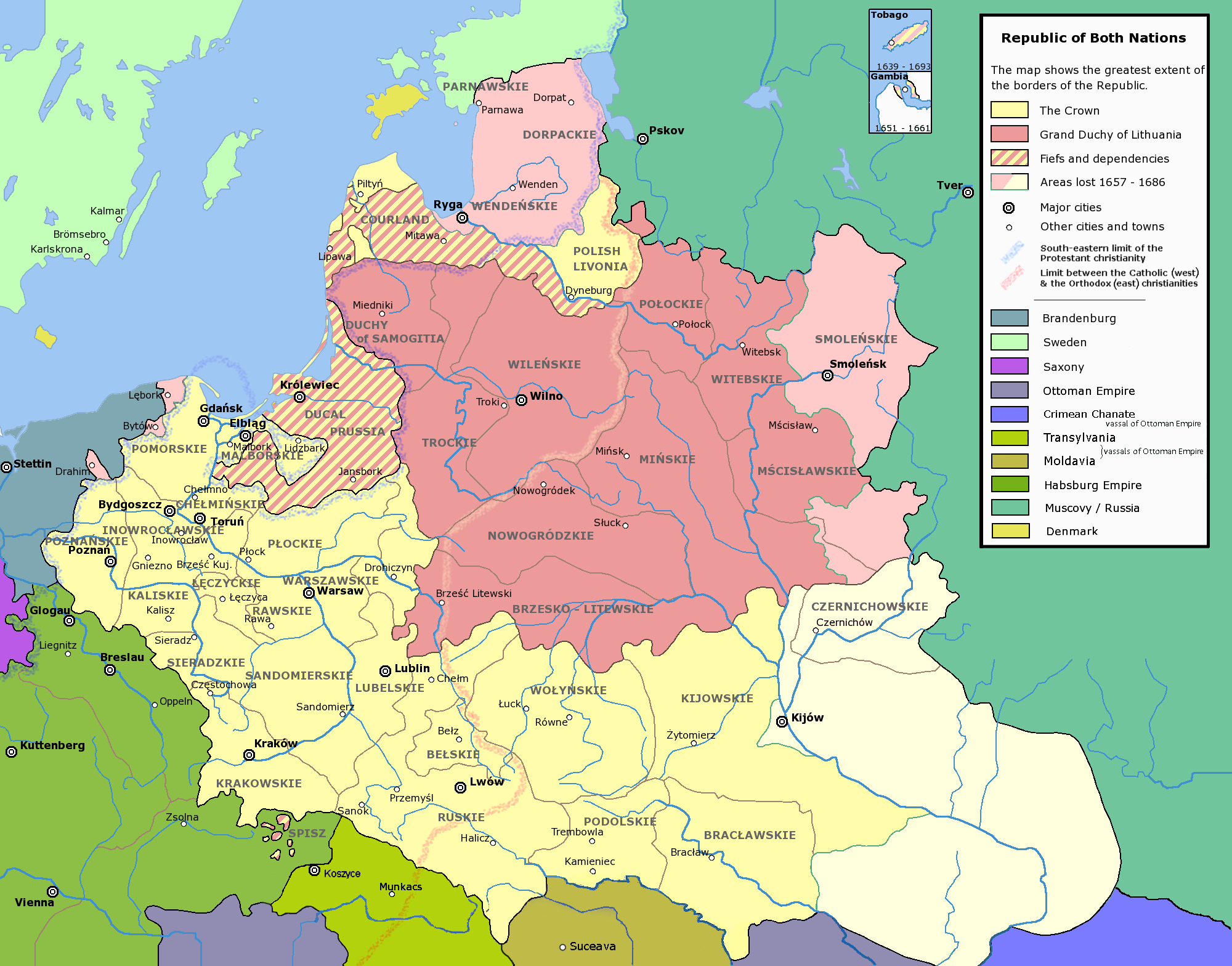
Deutsch: die polnisch-litauische de:Rzeczpospolita (Adelsrepublik)
Polski: Mapa przedstawiająca Rzeczpospolitą Obojga Narodów (czyli Koronę i Wielkie Księstwo Litewskie). Nazwy jednostek administracyjnych (województw, etc.) są przedstawione w języku polskim.
English: w:Voivodships of the Republic of Both Nations. The names of the voivodships are in Polish. In Polish the voivodships and other units of administrative division are traditionally referred to with their adjective forms, i.e. Płock Voivodship is referred to as (Województwo) Płockie (Literally Plockian voivodship), Podole Voivodship as (Województwo) Podolskie (literally Podolian Voivodship) and so on.
Français : Voïdodies de la République des Deux Nations. Noms géographiques en polonais. Les noms polonais des unités administratives sont sous leur forme adjective. Par exemple, la voïvodie de Plock est nommée Województwo Płockie (litéralement la "Voïvodie Plockienne").
|
| Burimi | Punë e juaja |
| Autori | Halibutt |
| Leja (Ripërdor këtë skedë) |
GFDL and Creative Commons Attribution-ShareAlike 3.0 |
| Versione tjera | العربيَّة |
The following is a list of maps created by Halibutt and uploaded to commons, as well as their present and projected derivatives.
| Parent Image | Image | Description | |||||||||||
|---|---|---|---|---|---|---|---|---|---|---|---|---|---|
| Maps by Halibutt | |||||||||||||
| Image:Rzeczpospolita.png | Image:Rzeczpospolita.png | The Republic in 17th and 18th century | |||||||||||
| Image:Rzeczpospolita 1600.png | The Republic after the Treaty of Dywilino | ||||||||||||
| Image:Rzeczpospolita voivodships.png | Voivodships of The Republic | ||||||||||||
| Image:Rzeczpospolita_Potop.png | The Republic during The Deluge and Chmielnicki Uprising, with major battles of the era marked | ||||||||||||
| Magnates and their lands and domains | |||||||||||||
| 1st • 2nd • 3rd | Partitions of Poland | ||||||||||||
| War of the constitution | |||||||||||||
| Image:Rzeczpospolita.xcf | SOURCE FILE - GIMP format | ||||||||||||
| Image:Poland 1939.png | Image:Poland 1939.png | Poland in 1939 | |||||||||||
| Image:Dywizje wrzesien 1.png | Order of Battle on September 1st, during the Polish Defence War of 1939 | ||||||||||||
| Image:Poland 1939.xcf | SOURCE FILE - GIMP format | ||||||||||||
| Image:Polska kontur bialy.png | Image:Polska kontur bialy.png | Contour map of Poland AD 1999, for use with various locator maps | |||||||||||
| Image:Rzeczpospolita 1923.png | Image:Rzeczpospolita 1923.png | Map of Poland 1918-1939, currently under development | |||||||||||
| Image:PBW March 1919.png | Polish-Bolshevik War - fronts in March of 1919 | ||||||||||||
| Image:PBW December 1919.png | Polish-Bolshevik War - fronts in December of 1919 | ||||||||||||
| Image:PBW June 1920.png | Polish-Bolshevik War - fronts in July of 1920 | ||||||||||||
| Image:PBW August 1920.png | Polish-Bolshevik War - fronts in August of 1920 | ||||||||||||
| Polish Defence War of 1939 | |||||||||||||
| Polish areas annexed by Germany, Lithuania, Slovakia and the Soviet Union | |||||||||||||
| German concentration camps in Poland | |||||||||||||
| Curzon line | |||||||||||||
| Major battles of the Polish-Bolshevik War | |||||||||||||
| names • no names | Polish/Czechoslovak/Lithuanian/German/Ukrainian claims in 1920's | ||||||||||||
| Image:Rzeczpospolita Central Lithuania.png | Central Lithuania | ||||||||||||
| Image:Rzeczpospolita Lithuania claims.png | Central Lithuania as compared with other Lithuanian claims | ||||||||||||
| Image:Rzeczpospolita 1789-1920.png | Post-1922 borders compared with the territory of Poland before the partitions | ||||||||||||
| Warsaw Uprising and the Operation Tempest | |||||||||||||
| Poland partitioned between the Soviets and the Germans | |||||||||||||
| Image:Rzeczpospolita 1939 Polish divisions.png | Polish divisions on September 1, 1939 | ||||||||||||
| Home Army inspectorates | |||||||||||||
| Image:Rzeczpospolita 1922.xcf | SOURCE FILE - GIMP format | ||||||||||||
| Image:Rzeczpospolita 1937.svg | Vector version!!!! | layered version available on request | |||||||||||
Licencim
Since the legal status of the above comment has been questioned, I hereby grant anyone the right to treat it as either a standard copyright notice, invariant section, legal statement, legal advice, friendly suggestion or a mere comment, depending on his or hers own choice. |
|

|
This image was selected as picture of the day on Wikimedia Commons for 5 April 2006. It was captioned as follows: Other languages:
Čeština: Vojvodství Republiky obou národů (polsko-litevské unie). Français : Voïvodies (régions administrative) de l'union polono-lituanienne. Polski: Podział administracyjny Rzeczypospolitej Obojga Narodów Português: Voivodias da comunidade comum polaco-lituana. Русский: Воеводства Речи Посполитой ไทย: เขตการปกครองของเครือรัฐโปแลนด์-ลิทัวเนีย |
Historiku skedës
Shtypni mbi një datë/kohë për ta parë skedën siç ishte atëherë.
| Data/Koha | Miniaturë | Përmasat | Përdoruesi | Koment | |
|---|---|---|---|---|---|
| e tanishme | 13 prill 2020 20:41 | | 2.000 × 1.568 (448 KB) | Claude Zygiel | Details since Stier, H.-E. (ed.) ''Grosser Atlas zur Weltgeschichte'', Westermann 1985, {{ISBN|3-14-100919-8}}, ''Putzger historischer Weltatlas'', Cornelsen 1990, {{ISBN|3-464-00176-8}} & Denis J.P., Frachon A., Giraud J., Michel R., Valet O. (eds.) ''Atlas des Religions'' - H.S. ''Le Monde'' 2009. |
| 24 shkurt 2010 15:39 |  | 2.000 × 1.568 (273 KB) | Dcoetzee | Remove watermark, pngcrush | |
| 7 shkurt 2007 09:57 |  | 2.000 × 1.568 (253 KB) | Tene~commonswiki | Optimised (0) | |
| 13 dhjetor 2004 21:23 |  | 2.000 × 1.568 (397 KB) | Halibutt | Ok, final version at last (unless you have some more comments or suggestions) | |
| 10 dhjetor 2004 09:47 |  | 2.000 × 1.568 (386 KB) | Halibutt | Voivodships of the Republic of Both Nations<br><br> A derivative work of Image:Rzeczpospolita.png<br>Please refer to that graphic's page for more detailed description, licensing information and such.<br>{{User:Halibutt/GFDL}}<br>{{User:Halibutt/maps} |
Lidhje skedash
Këto faqe lidhen tek kjo skedë:
Përdorimi global i skedës
Kjo skedë përdoret nga Wiki të tjera në vijim:
- Përdorimi në af.wikipedia.org
- Përdorimi në ar.wikipedia.org
- Përdorimi në azb.wikipedia.org
- Përdorimi në bg.wikipedia.org
- Përdorimi në da.wikipedia.org
- Përdorimi në de.wikipedia.org
- Përdorimi në el.wikipedia.org
- Përdorimi në en.wikipedia.org
- Talk:Daniel Gabriel Fahrenheit/Archive 1
- Lublin Voivodeship
- Grand Duchy of Lithuania
- Crown of the Kingdom of Poland
- Portal:Lithuania
- Administrative divisions of Poland
- Portal:Maps/Maps/Political
- Portal:Maps/Maps/Political/10
- Talk:Voivodeships of Poland/Archive 1
- Talk:Name of Ukraine/Archive 1
- Talk:Polish–Lithuanian Commonwealth/Archive 2
- User:Falcaorib
- Përdorimi në eo.wikipedia.org
- Përdorimi në es.wikipedia.org
- Përdorimi në fr.wikipedia.org
- Përdorimi në he.wikipedia.org
- Përdorimi në ia.wikipedia.org
- Përdorimi në it.wikipedia.org
- Përdorimi në ka.wikipedia.org
- Përdorimi në ko.wikipedia.org
- Përdorimi në ku.wikipedia.org
- Përdorimi në lt.wikipedia.org
Shikoni më shumë përdorim global të kësaj skede.