
Skeda:Simplified Languages of Europe map.svg

Size of this PNG preview of this SVG file: 737 × 599 pixel. Rezolucione të tjera: 295 × 240 pixel | 590 × 480 pixel | 945 × 768 pixel | 1.259 × 1.024 pixel | 2.519 × 2.048 pixel | 1.541 × 1.253 pixel.
Dokument origjinal (skedë SVG, fillimisht 1.541 × 1.253 pixel, madhësia e skedës: 2,25 MB)
| Kjo skedë është prej Wikimedia Commons dhe mund të përdoret nga projekte të tjera. Përshkrimi në këtë skedë në këtë faqe nuk është treguar më poshtë. | Shko tek faqja përshkruese në Commons |
Përmbledhje
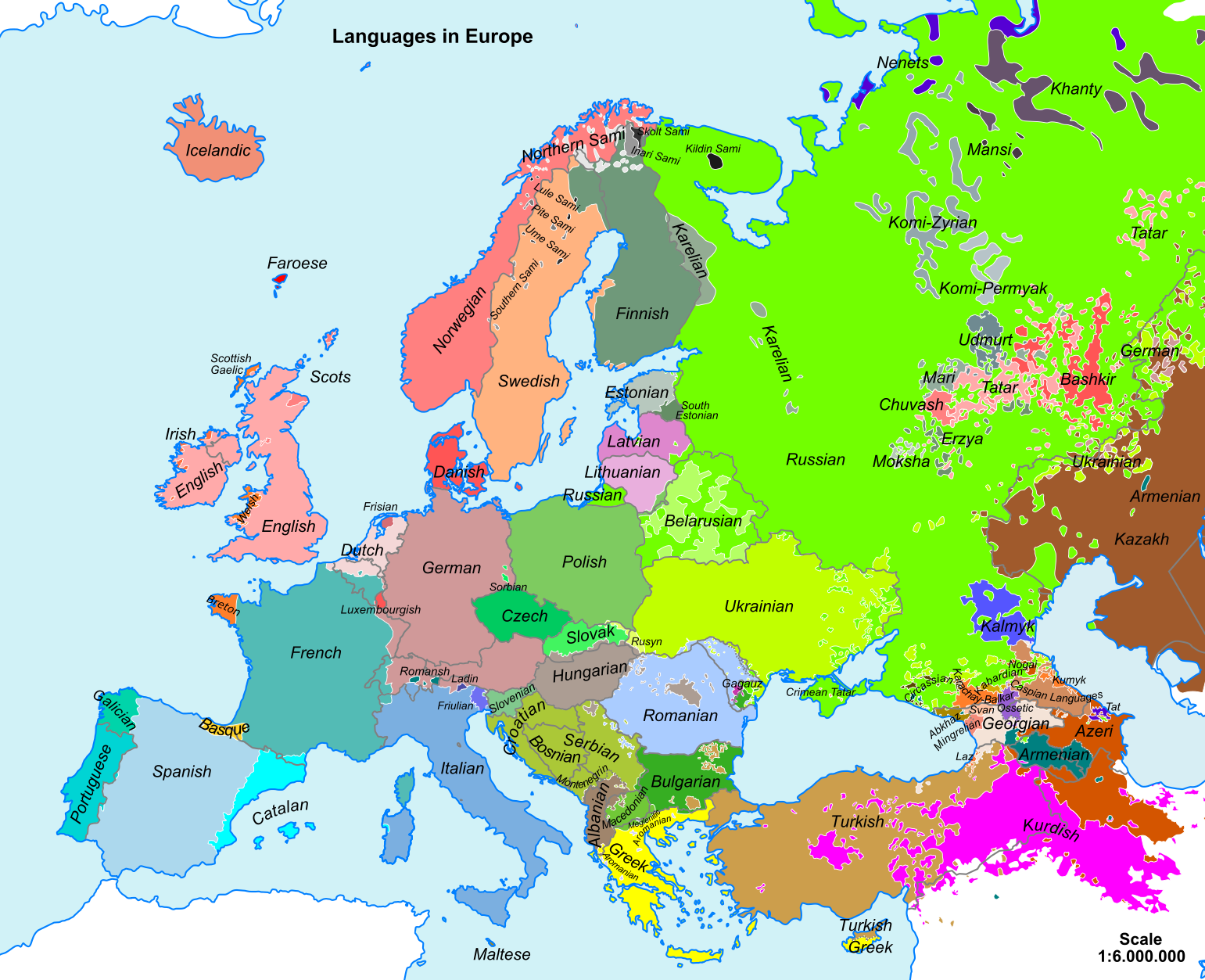
| Përshkrimi | Map of main European languages simplified by following national borders in many cases. The map does not reflect the fact that many regions are bilingual, officially and/or in practice. In some cases, the area indicated for a language reflects where some of its speakers live but not necessarily where they form the majority of the population. |
| Data | 22 nëntor 2008 (original upload date) |
| Burimi |
Punë e juaja Sources for data:
|
| Autori |
See below. / [] By language codes: SVG, jpg, png; English: SVG , simplified SVG , rectified PNG ; Esperanto 1 , 2 , 3 , français , македонскиעברית |
| SVG genesis |

Licencim
| Unë,krijuesi i kësaj pune, e lëshoj këtë punë në public domain. Kjo aplikohet në të gjithë botën. Në disa vende kjo mund të mos jetë e mundur ligjërisht; nëse është kështu: Unë i garantoj çdokujt të drejtën për ta përdorur këtë punë për çdo qëllim, pa asnjë kusht, përveç rasteve kur këto kushte janë të kërkuara nga ligji. |
Historiku skedës
Shtypni mbi një datë/kohë për ta parë skedën siç ishte atëherë.
| Data/Koha | Miniaturë | Përmasat | Përdoruesi | Koment | |
|---|---|---|---|---|---|
| e tanishme | 6 korrik 2023 20:54 | | 1.541 × 1.253 (2,25 MB) | Petnog | Almost no one speaks only mirandese (and either way, it's not spanish). Also, barranquenho is a portuguese dialect, despite having spanish influence |
| 9 shkurt 2022 13:26 |  | 1.541 × 1.253 (2,25 MB) | Parodper | Fixed Galician borders | |
| 21 mars 2021 05:08 |  | 1.541 × 1.253 (2,25 MB) | YoungstownToast | Reverted to version as of 14:40, 8 March 2019 (UTC). Incorrect | |
| 10 janar 2020 15:17 |  | 1.541 × 1.253 (2,28 MB) | ZxcvU | More accurate borders of Ukrainian. | |
| 8 mars 2019 16:40 |  | 1.541 × 1.253 (2,25 MB) | NikNaks | Revert to true SVG; if you wish to remove content or make edits, please do so in Inkscape or another vector editor, do not upload a PNG in an SVG wrapper | |
| 9 shkurt 2019 14:15 |  | 1.420 × 1.320 (990 KB) | A2D2 | Reverted to version as of 22:30, 23 February 2017 (UTC) This file is only about the languages in Europe. | |
| 11 janar 2019 22:33 |  | 1.541 × 1.253 (2,25 MB) | Kun Kipcsak | Added the Hungarian speakers from romanian Moldova > the Csango speech of north and south (Săbăoani and Pustiana; Faraoani), also with hungarian of Csangos of Ghimeș, Bacău. | |
| 27 mars 2018 02:06 |  | 1.541 × 1.253 (2,25 MB) | R9tgokunks | tweaking Romance languages in France & Italy per File:Romance_20c_en.png and File:Romance_languages.png | |
| 21 dhjetor 2017 13:11 |  | 1.541 × 1.253 (2,29 MB) | DiaouligRu | Added Breton speaking populations according to File:Indo-European_languages_in_Europe.png, File:Percentage_of_breton_speakers_in_the_breton_countries_in_2004.png and File:Image-Languages-Europe.png. | |
| 24 shkurt 2017 11:45 |  | 1.600 × 1.320 (2,28 MB) | Scooter20 | Please remake your changes in SVG not bitmap as there is a huge drop in quality after your changes. Also not sure about removing adjacent or "sometimes included in Europe" countries from the map. |
Lidhje skedash
S’ka faqe që përdorin këtë kartelë.
Përdorimi global i skedës
Kjo skedë përdoret nga Wiki të tjera në vijim:
- Përdorimi në cs.wikipedia.org
- Përdorimi në de.wikipedia.org
- Përdorimi në el.wikipedia.org
- Përdorimi në en.wikipedia.org
- Përdorimi në en.wiktionary.org
- Përdorimi në es.wikipedia.org
- Përdorimi në gl.wikipedia.org
- Përdorimi në hu.wikipedia.org
- Përdorimi në hy.wikipedia.org
- Përdorimi në hyw.wikipedia.org
- Përdorimi në ka.wikipedia.org
- Përdorimi në ko.wikipedia.org
- Përdorimi në lfn.wikipedia.org
- Përdorimi në li.wikibooks.org
- Përdorimi në lt.wikipedia.org
Shikoni më shumë përdorim global të kësaj skede.